GPS lll Progress Report Update From Excelis

Exelis says it has successfully completed and fully tested six transmitter assemblies, which are integral payload components for the first in a series of the next generation of GPS III navigation satellites. The navigation payload transmitters carry high-powered GPS signals from space to Earth, benefitting military, commercial and civilian users. To ensure the space vehicle navigation payload meets performance requirements over the mission life, Exelis subjected the transmitter assemblies to a rigorous test program which includes random vibration…
New Bridge Simulator For Mexican Coastal and Port Development

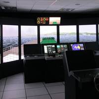
A new Multi-Purpose Kongsberg Maritime Polaris ship’s bridge simulator has become a key coastal and port development resource for The Instituto Mexicano del Transporte (IMT) following the opening of its new research facility in August 2013. Based in Queretaro, Mexico, IMT is the leading Research Center for Ports and Coasts in Mexico. The organization is using its new Polaris simulator, which was ordered in April 2013, within its maritime research, development and project planning activities.
GPS Signal Jammers Stymied by Exelis
Exelis' Signal Sentry 1000 device detected and located GPS interference sources in 3-D by using longitude, latitude and altitude, during recent field tests at the Vidsel Test Range in Sweden. Taking advantage of the range’s remote location, Exelis was able to conduct tests of its Signal Sentry 1000 product using controlled jamming. The test was conducted without disrupting the GPS signal relied upon by civilian and military operations outside of the test range location. The test employed eight sensors positioned in an array pattern and showed that Signal Sentry was able to successfully detect and locate the jamming source. Having demonstrating interference detection and location capability…
OSI $1.3m Contract with Australian Navy
OSI Geospatial Inc. (TSX:OSI) announced that its International Systems Operations has signed a contract with the Australian Navy valued at approximately $1.3m. Under the terms of the contract, the company will provide a software upgrade and 12 months of software support. OSI Geospatial Inc. delivers advanced geospatial systems and software that enable shared real-time situational awareness for military and security applications. OSI products and services enable customers to integrate and visualize live data with any combination of sensor data, imagery, maps and charts. (www.osigeospatial.com)


