NOAA Satellites Helped Save 253 People in 2013

The same NOAA satellites that helped forecasters predict severe weather, such as the Moore, Okla., tornado last May and November’s deadly Midwest tornado outbreak, also played a key role in rescuing 253 people from potentially life-threatening scenarios throughout the United States and its surrounding waters last year.
A combination of NOAA polar-orbiting and geostationary satellites detected distress signals from emergency beacons carried by downed pilots, shipwrecked boaters and stranded hikers and relayed information about their location to first responders on the ground.
NOAA satellites are part of the international Search and Rescue Satellite Aided Tracking System, called COSPAS-SARSAT. This system uses a network of satellites to quickly detect and locate distress signals from emergency beacons onboard aircraft and boats, and from smaller, handheld personal locator beacons called PLBs.
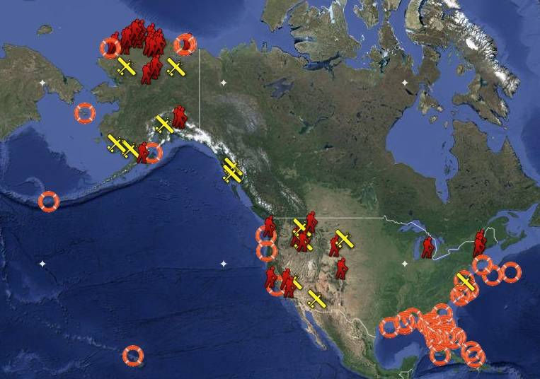
Of the 253 rescues, 139 were waterborne rescues, 34 were from aviation incidents and 80 were from events on land, where PLBs were used. Other rescue highlights from last year include:
- Alaska had the most SARSAT rescues, with 101, followed by Florida, with 56;
- In Alaska, six passengers on a small plane were rescued after it crashed near mountainous terrain outside of Le Conte Bay, Alaska;
- Four crewmen, ejected from a B-1 bomber before it crashed, were rescued in Broadus, Mont.; and
- A boater was rescued off the coast of Kitty Hawk, N.C., after he sustained a head injury.
“Each life we save underscores the undeniable value of NOAA satellites,” said Mary Kicza, assistant administrator for NOAA’s Satellite and Information Service.
When a NOAA satellite finds the location of a distress signal, the information is relayed to the SARSAT Mission Control Center based at NOAA’s Satellite Operations Facility in Suitland, Md. From there, the information is quickly sent to a Rescue Coordination Center, operated by either the U.S. Air Force for land rescues or the U.S. Coast Guard for water rescues.
Since 1982, COSPAS-SARSAT has been credited with supporting more than 35,000 rescues worldwide, including more than 7,250 in the United States and its surrounding waters.
By law, owners of emergency beacons are required to register them with NOAA at: http://www.beaconregistration.noaa.gov. That registration information often helps provide better
and faster assistance to people in distress. It may also provide information about the location of the emergency, how many people need assistance, what type of help may be needed and other ways to contact the owner. At the end of 2013, NOAA’s registration database contained more than 400,000 registrations.
noaa.gov