Blue Sky Adds Map Overlay Features to SkyRouter

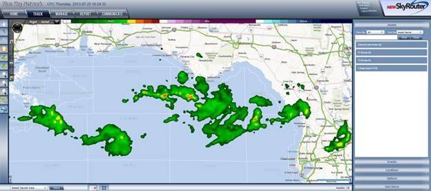
Blue Sky Network, a supplier of satellite tracking and communication solutions for aviation, land and marine, announced several new map overlay enhancements to its cloud-based fleet management solution, New SkyRouter. The new overlays include third-party weather feeds and localized traffic information from Bing Maps. Blue Sky Network also provides an overlay for oil and gas lease block data in the Gulf of Mexico and customer specific overlays such as pipelines or power lines. These enhancements can be combined with existing asset tracking information to improve a single map view source. This allows operators to manage assets and routing in near real-time based on changing conditions leading to improved fleet efficiency and safety.
New SkyRouter combined with Blue Sky Network’s tracking hardware enables fleet managers to stay in constant communication with widely dispersed global assets. Fleet managers can now benefit from a combination of data sets pulled from multiple sources into a single platform to display other external factors, which will allow better control overall. For instance, the weather overlay feature streams information from providers such as WSI Corporation, a leading provider of weather-driven business solutions. When weather emergencies seem imminent, fleet managers can better coordinate and direct changes, including the sending of notifications. This will allow for the opportunity to make routing adjustments in order to avoid unsafe areas or to improve travel times.
Jon Gilbert, CEO of Blue Sky Networks,said, “With the new overlay features, we are providing operators with a more complete view of their assets’ changing situations and allowing them to quickly address any operational concerns.”
Additionally, the new oil and gas lease block overlay can assist offshore operators with the transportation of personnel and equipment to production platforms and drilling rigs in the Gulf of Mexico. When used in combination with the weather overlay, it helps to ensure the highest level of efficiency and service by providing important location and environmental information affecting the asset within a single map view. With these new upgrades fleet managers are better informed to make quick and efficient decisions.
The new map overlay features are currently in beta release and expected to be in production by September 2013. Blue Sky Network will be demonstrating its new map overlay features at LABACE 2013, taking place in São Paulo, Brazil – August 14-16, in booth #5020.
blueskynetwork.com