

Need a Survey? There’s a USV for That
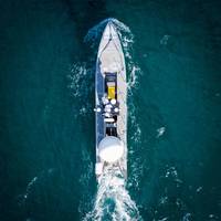
While the adoption of unmanned/uncrewed surfaces vessels (USVs) was initially in defence, use of these low footprint systems has spread into other sectors, not least survey, and now the race is on for greater capability, endurance and autonomy. Elaine Maslin reports.After starting small, in inland waterways, use of USVs for survey operations has moved into coastal and now offshore waters. Given the extensive amount of seabed and rapid growth in offshore wind, there’s plenty of work out there for them to do.With the travel restrictions posed by Covid and increasing awareness of climate change…
Fugro's New USV to Chart Waters Off South Australia
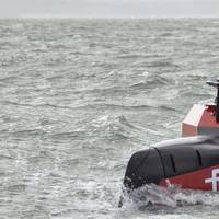
Fugro will use its new uncrewed surface vessel (USV) to chart the waters of South Australia’s Gulf St Vincent and Investigator Strait as part of the Australian Government’s HydroScheme Industry Partnership Program (HIPP).The Dutch-based offshore survey services company will carry out the 998 km2 survey will be conducted on behalf of the Australian Hydrographic Office (AHO), which will use the data to update nautical charts for safer navigation. Data will also be shared with scientific agencies…
Survey Vessels Hit the Charts
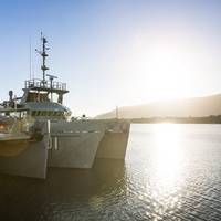
Training to ‘fight and win at sea’ occurs across the Navy every day of the year, but how does that concept map to the hydrographic fleet and their motto ‘diligence and skill’? – step into the world of the Navy’s survey motor launches. HMAS Mermaid, one of four Paluma class vessels, recently completed an intensive five and a half week training program in North Queensland waters in company with her sister ship HMAS Paluma. The ship and her 15-person crew were put through their paces by Navy’s in-house training and assessment team – Minor War Vessel Sea Training Group.
Traffic Separation Schemes off Western Australia
On 1 December 2016 two new Traffic Separation Schemes (TSS) will come into effect off the south-west coast of Western Australia. Australia’s proposal to establish the schemes was approved by the International Maritime Organization earlier this year and adopted by its Maritime Safety Committee in May. A TSS separates opposing streams of traffic by establishing traffic lanes and separation zones. The two schemes, off Cape Leeuwin and Chatham Island in the state’s south-west, aim to increase navigational safety by reducing the number of head-on situations and improve environmental protection by keeping ships away from the coast line. AMSA’s proposal stemmed from shipping traffic data which raised concerns about ships on reciprocal courses and navigating close to the coast line.
Australian Electronic Chart Service Launched
AMSA's Acting Chief Executive Officer, Mr Mick Kinley, was a guest of honour at a celebration held at the Australian Hydrographic Office in Wollongong on Thursday 21 June to celebrate United Nations World Hydrography Day. Commodore Rod Nairn AM, RAN (Hydrographer of Australia) used the event to mark Australia's achievement of Electronic Navigational Chart (ENC) coverage for Australian and Papua New Guinea waters and to launch a new Australian Electronic Navigational Chart service (AusENC). The AusENC service will support vessels operating within Australian and Papua New Guinea waters through simple ordering and easy availability of official charts for use in Electronic Chart Display and Information Systems (ECDIS).
Transas Moves Towards Auto Integrated Navigation
With the Navi-Sailor 2400 ECDIS becoming the world's first type approved ECDIS, the company's latest development — Navi-Sailor 2500 — goes even further in the automation of full bridge navigation. Navi-Sailor 2500 is equipped with a number of innovative functions that bring this product to the summit of modern shipping electronics. In addition to the vector charts of S-57 ver.3 format and raster ARCS and NDI/BSB, the new system can incorporate Seafarer raster charts produced by the Australian Hydrographic Office. The enhanced User Chart Editor now offers as many as 15 colors for easier identification and definition. The software of Navi-Sailor 2500 also provides the facility for underwater object tracking and monitoring.


