

Navionics Debuts SonarCharts
Navionics, the leader in location-based content for the recreational boating and outdoor markets, announced today the release of a new SonarCharts chart card for use with several Garmin GPS chartplotters. Featuring extraordinary bottom contour detail of up to 1 foot in the US and Canada, the new version of SonarCharts HD bathymetry map for use with several Garmin GPS chartplotters offers the most detail available anywhere, and is great for increasing awareness of shallow waters and locating fishing areas at any depth level. The SonarCharts card also includes navigational aids, providing a complete resource for all boating activities.
iPhone Adapter for Night Vision Scope
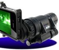
NightVisionExperts.com, a leading North American provider of night vision equipment, has debuted a revolutionary new night vision scope iPhone adapter that links two well deployed emergency first responder technologies, the PVS-14A Night Vision Scope and Apple’s iPhone smartphone for use by emergency responders in the field. The slide-on adapter precisely mounts a PVS-14A night vision scope over the iPhone’s 8-megapixel camera lens. With a single tap first responders can now securely upload high resolution night vision photos…
OW Bunker Launches Free iPhone App
OW Bunker, a supplier and trader of marine fuel, has announced the launch of a free application for the Apple iPhone and iPod Touch. This app, the first ever from a bunker supplier and the first for the marine fuel market, currently contains ISO8217-2010 fuel standards data and a fuel calculator, with more features coming soon. It can be downloaded now from Apple’s App store. The app, which complies to ISO8217-2010 standards for residual and distillate marine fuel, features a fuel calculator designed to measure Specific Energy content, the CCAI (Calculated Carbon Aromatic Index) Number, the Viscosity Index and the Volume Correction Factor (VCF). All four calculations are essential for those working with marine fuels.
Marine Travel Agent App for the iPhone/iPad
The Marine Travel Company, a specialist agency handling marine travel worldwide, has introduced an iPhone and iPad application for anyone on the move in the maritime industry. Maritime industry travelers can now access the company’s reservations team and website instantly. The app App features: • Instant flight requests from your iphone/ipad • Quick and Easy access to your flight itinerary • Online check in, contact us and more links Download at http://itunes.com/apps/crewtravel After a trial period on Apple’s iphone/ipad operating system the marine travel company will look to develop similar programs for Blackberry, Palm and Smartphone. www.themarinetravel.co.uk
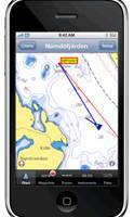
Navionics Chart Support Added to iPhone
Software manufacturer Northport Systems Inc. announced that its popular Fugawi X-Traverse online map collection for use with iNavX marine software for the Apple iPhone now supports Navionics marine and outdoor charts. Adding to iNavX’s support of raster maps including NOAA RNC, Swedish Marine Charts, and TRAK Maps, users now have subscription-based, fingertip access to world-wide Navionics Gold+ international marine, HotMaps Premium North American fishing and European Discovery outdoor charts from www.X-Traverse.com. Navionics charts are downloaded directly into iNavX software through the iPhone’s internet connection (Edge, 3G or WiFi) and saved locally on the phone for use when outside of cell phone or WiFi internet coverage.
Fugawi X-Traverse Supports Online Charts
Software manufacturer Northport Systems Inc. announced the addition of Hilton’s Realtime-Navigator support to its online Fugawi X-Traverse collection for use with Fugawi navigation software, Apple iPhone and MacENC for Apple OS X. The combination of Fugawi X-Traverse and Hilton’s Realtime-Navigator gives users an unparalleled set of ocean condition tools to identify fish holding locations. The ultimate saltwater fishing tool, Fugawi X-Traverse provides users of the iPhone, PCs or Macs with the most up-to-date water condition detail. Hilton’s Realtime-Navigator provides boaters with unlimited access to the latest sea surface temperature…
Fugawi Swedish Marine Charts
Software manufacturer Northport Systems Inc. announced the addition of Swedish Marine Charts to its online Fugawi Touratel Map collection for use with Fugawi navigation software and the Apple iPhone. The X-Traverse chart and map data distribution system is also now available for integration by third-party developers who wish to easily add marine charts and land maps to their mobile applications. Compatible with Fugawi Marine ENC and Fugawi Global Navigator navigation software for PC…


