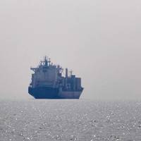
USCG Issues AIS Safety Warning Following Towboat Collision
The U.S. Coast Guard has issued a safety alert highlighting the importance of accurate Automatic Identification System (AIS) data entry and display to safe navigation following a recent towboat collision on the Mississippi River.Although the investigation into this casualty is not yet complete, the Coast Guard said the incident shows the hazards created by inaccurate AIS data and should prompt owners and operators to review and update their procedures to prevent similar casualties from occurring.Before sunrise, two towing vessels were approaching a bend on the Mississippi River.
'Significant' GPS Interference Incidents Reported
The U.S. Maritime Administration (MARAD) is advising vessel operators to exercise extra caution and safe navigation practices after multiple instances of significant GPS interference have been reported over the last year by vessels in port and underway in the eastern and central Mediterranean Sea, the Persian Gulf, and the Port of Shanghai, China.The incidents have resulted in lost or inaccurate GPS signals affecting bridge navigation, GPS-based timing, and communications equipment…
USCG Navigation Center: Steering a steady course for safe, secure, efficient waterways

The U.S. Coast Guard’s Navigation Center (NAVCEN) is involved in a number of activities that have an impact on all Americans, even if they don’t realize it.From motorists checking directions with their Global Positioning System (GPS) to boaters to ships coming and going to U.S. ports, the NAVCEN plays an unseen but vital role.With a staff of19 officers, 17 enlisted personnel and 19 civilians, NAVCEN falls under the Director of Marine Transportation Systems (CG-5PW) at USCG Headquarters…
US Coast Guard to Discontinue Remaining DGPS Sites
The U.S. Coast Guard announced today it will discontinue broadcasts from its remaining 38 Differential GPS (DGPS) sites over the next three years, completing system reductions that began in 2016. The staged reduction of the remaining Coast Guard DGPS broadcast sites will begin in 2018 and end with the last broadcast of GPS corrections over medium frequency in 2020. The U.S. Coast Guard Navigation Center has operated the Nationwide DGPS Service since 1999 to broadcast correction signals on marine radiobeacon frequencies to improve the accuracy and integrity to GPS-derived positions. Lt. Cmdr. “GPS provides sufficient positional accuracy to meet navigation requirements for harbor approaches and to position Federal Aids to Navigation,” Patterson said.
Cyber Threats Prompt Return of Radio for Ship Navigation
The risk of cyber attacks targeting ships' satellite navigation is pushing nations to delve back through history and develop back-up systems with roots in World War Two radio technology. Ships use GPS (Global Positioning System) and other similar devices that rely on sending and receiving satellite signals, which many experts say are vulnerable to jamming by hackers. About 90 percent of world trade is transported by sea and the stakes are high in increasingly crowded shipping lanes.
Safeguarding GPS When Global Positioning Doesn’t Work
Suppose the Global Positioning System (GPS) receivers used for your vessel, offshore oil platform, or port facility could not generate position data needed for your operations. How would your crew or staff respond? Initial troubleshooting efforts may indicate equipment failures, antenna masking, or possibly human error. Additionally, the lack of position data will likely force your crew or staff to resort to secondary means to obtain position information. If position data cannot be regained, then the receivers may have lost GPS due to intentional or unintentional interference.
Country’s Largest Floating Drydock Coming to Portland
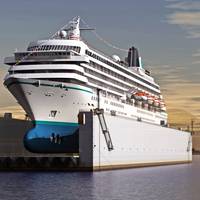
The country’s largest floating drydock, the Vigorous, is headed for Portland this weekend. The drydock, a piece of equipment used to lift vessels as large as cruise ships out of the water, is scheduled to arrive at the mouth of the Columbia Sunday. It will make its way up to Vigor Industrial’s Portland shipyard on the Willamette River by Sunday evening or Monday morning, depending on weather and river traffic. Fully assembled, the drydock will be 960-feet long. However, it is currently in three parts, which are stacked aboard a 738-foot heavy lift ship for delivery.
US Coast Guard to Terminate Guard on 2 mHZ Frequencies
Effective 01 August, 2013, the U. S. Coast Guard will terminate its radioguard of the international voice distress, safety and calling frequency 2182 kHz and the international digital selective calling (DSC) distress and safety frequency 2187.5. Additionally, marine information and weather broadcasts transmitted on 2670 kHz will terminate concurrently. The authority adds that this safety alert is provided for informational purposes only and does not relieve any domestic or international safety, operational or material requirement.
USCG – GPS testing off North Carolina
The USCG Navigation Center (NAVCEN) has issued a special notice stating that, from 3 through 10 February daily from 1600 EST to 2145 EST, the GPS navigation signal in waters off Wilmington, North Carolina may be unreliable due to testing of GPS signals used by shipboard, aviation, and handheld navigation devices. From Feb 03 through Feb 10, 2012, daily from 1600 EST to 2145 EST, the GPS navigation signal may be unreliable due to testing on GPS frequencies used by shipboard navigation, aviation and handheld systems. Systems that rely on GPS, such as E-911, AIS and DSC may be affected at an approximate testing center point of 33 45.00N, 77 00.00W, with an impact radius of approximately 75 NM from center point.
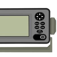
Reminder of Proper Channel for AIS
The U.S. Coast Guard Navigation Center issued a special notice reminding mariners that any vessel operating in U.S. waters equipped with an Automatic Identification System (AIS) should confirm that the proper channel frequency has been selected. The standard default AIS frequency is 161.975 MHz (AIS1 or channel 87B). The alternate AIS frequency is 162.025 MHz (AIS2 or channel 88B). These frequencies can be verified through the manufacturer’s operation/owner’s manual for the AIS installed. (8/23/10). (Source: Bryant’s Maritime News)
Photo Release: CG Terminates LORAN-C
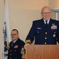
Vice Adm. Robert J. Papp speaks at a ceremony to mark the shutting down of the LORAN-C signal at the Navigation Center in Alexandria, Va., Feb. 8. Both the maritime and aviation communities have used LORAN-C signals for navigation for more than 67 years. (U.S. The U.S. Coast Guard terminated broadcast of the North American Long Range Navigation-C signal at 3 p.m. Feb. 8 with the U.S. Coast Guard Navigation Center in Alexandria, Va., coordinating the shutdown. The LORAN system…
USCG NAVCEN Change of Mailing Address
The U.S. Coast Guard Navigation Center issued a Special Notice stating that its mailing address has changed. Mail sent to the previous address will not be delivered. The new mailing address is: US Coast Guard Navigation Center NAVCEN MS 7310 7323 Telegraph Road Alexandria, VA 20598-7310 (Source: Bryant’s Maritime News)
USCG, High HDOP Advisory
The U.S. Coast Guard Navigation Center issued a High Horizontal Dilution of Precision (HDOP) Advisory stating that GPS users in certain parts of the world may experience a short period of high HDOP/PDOP on October 8 as a result of a routine Delta-V maneuver with satellite #52 (PRN-31). (10/6/09). (Source: Bryant’s Maritime News)
USCG – HDOP Advisory
The U.S. Coast Guard Navigation Center issued an advisory stating that GPS users may experience short periods of high horizontal dilution of precision (HDOP) on September 11 as a result of a routine Delta-V maneuver with satellite #52 (PRN-31). (9/9/09). (Source: Bryant’s Maritime News)
Differential GPS Site Closure
The Miami, FL DGPS site, broadcast frequency 322 kHz, will be decommissioned and taken permanently off-line September 8, 2009 at 1200 EST. NAVCEN operates the Coast Guard Maritime Differential GPS (DGPS) Service and the developing Nationwide DGPS Service, consisting of two control centers and over 80 remote broadcast sites. The Service broadcasts correction signals on marine radiobeacon frequencies to improve the accuracy and integrity to GPS-derived positions. The Coast Guard DGPS Service provides 10-meter accuracy in all established coverage areas. Typically, the positional error of a DGPS position is 1 to 3 meters, greatly enhancing harbor entrance and approach navigation.
Marine Nav Data Moves to the Internet
Alameda, Calif. – The Eleventh Coast Guard District will begin posting weekly marine navigation information for the State of California on the Coast Guard Navigation Center’s website at http://www.navcen.uscg.gov/lnm/default.htm on April 1. This move is designed to improve service and reduce costs. The Local Notice to Mariners (LNM) for California is published weekly by the Eleventh Coast Guard District Aids to Navigation office in Alameda. The LNM provides information on changes or deficiencies in maritime aids-to-navigation and navigational chart information, as well as details on advanced notice marine activities. "By using the internet…