

Interview: Toyohisa Nakano Discusses "K" Line Green Initiatives
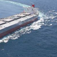
Last year Kawasaki Kisen Kaisha, Ltd. (“K” Line) – one of the world’s largest and most influential ship owners with 478 ships comprising 40.5 million DWT and more than 6,000 employees – celebrated its 100th anniversary. Toyohisa Nakano, Executive Officer, in charge of Ship Technical and Environmental Affairs for “K” Line, is a 30+ year veteran of the company. He discusses with Maritime Reporter & Engineering News the ship owner’s strategy to meet ever-tightening ship emission regulations.Please provide an overview of the ships you have on order today.We placed an order for 210…
Round the Clock Business Demands Seamless Comms
Network Innovations and its inland waterways connectivity solution eliminates “dead spot” coverage woes. And, not a moment too soon.The bane of inland operators – or at least one of many – has always been the dearth of reliable and economical vessel-to-shore communications. Even in America’s heartland where cellular coverage is routinely billed as seamless, so-called ‘dead spots’ persist. Sometimes, this happens at the worst possible moment for an operator who has myriad far flung assets on dozens of remote inland waterways. For a long time, satellite service has not been deemed economically feasible for inland operators. Beyond that, unlike blue water deep sea operators, there was little need to download data or employ software solutions in every day operations.
SCI expands its Coastal Shipping Services
The new restructured SMILE Service synergizes Shipping Corporation of India’s (SCI) Services with Shreyas’s Services and seamlessly links up Persian Gulf with East Coast of India and West Coast of India, thereby, further strengthening and expanding SCI’s presence in the Coastal Shipping Sector. The working together of two Lines, i.e., The SCI and Shreyas, on this route will be a force multiplier for SCI which will provide a high quality of Coastal Services on fixed day fixed window and will set the agenda, for SCI, for even bigger expansion in Coastal and near Coastal trades with special emphasis on the East Coast of India ports. With a view to optimize and in order to maintain the SMILE Service’s quality and operational efficiency…
Imports Settling Down After Surge to Clear Backlog
Import cargo volume at the nation’s major retail container ports is returning to normal levels as officials prepare to count votes on ratification of a new West Coast labor agreement that ended months of uncertainty, according to the monthly Global Port Tracker report released today by the National Retail Federation and Hackett Associates. “Dockworkers and management made a massive push to clear the backlog of cargo over the past several weeks and West Coast ports are getting back to normal despite concerns such as the Teamster picketing seen in Los Angeles and Long Beach earlier this month…
NOAA Reports 2011 Ocean, Great Lakes Economy Data
NOAA’s newest output includes a feature on economics. The National Ocean Watch site features facts, charts, story maps and videos. It turns out that our maritime economy – commercial, recreational and everything in between – really matters. In 2011, the U.S. Ocean and Great Lakes economy produced $282 billion in goods and services and employed 2.2 percent of the nation’s workers—that’s more than twice the percentage of workers in the U.S. agriculture industry. This fact and many others are featured in a 2011 data summary from Economics: National Ocean Watch (ENOW)…
NOAA Data Reveals Weight of Ocean and Great Lakes Economy
In 2011, the U.S. ocean and Great Lakes economy produced $282 billion in goods and services and employed 2.2 percent of the nation’s workers—that’s more than twice the percentage of workers in the U.S. agriculture industry. This fact and many others are featured in a 2011 data summary from Economics: National Ocean Watch (ENOW), a product of the National Oceanic and Atmospheric Administration (NOAA) Coastal Services Center. County-level facts, charts and maps highlighting the 2011 data findings are found on the “Ocean Jobs” and “Wetland Benefits” tabs of the Coastal County Snapshots tool.
Presentations Illustrate Dimensions of Accurate Marine Mapping
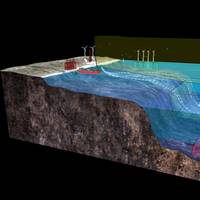
Two new products—the Ocean Dimensions animation and Crowded Ocean Spaces: A 3D View visualization—explain why two-dimensional marine maps cannot tell the whole story. Understanding this fact helps viewers gain a more accurate picture of marine-siting conflicts and compatibilities, including those related to offshore wind energy development. Traditional maps can give the false impression that the marine space is very crowded. In reality, marine uses are spread out among many dimensions: the sea surface, seafloor, water column, air column and even the dimension of time.
Veka-Group Develops LNG Tankers
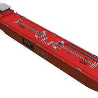
Veka-Group has developed three new LNG tankers, which can also be used as bunker ships. Two tankers are destined for short sea trips and/or coastal services. The third tanker, a LNG inland waterway bunker ship, is the first of its type in the world. The tanker sails almost completely on the ‘boil off’ of the load and is 100% emission-free. After the introduction of the first bi-fuel tanker in the world, the “Pioneer Knutsen”, this is again a proof of Veka-Group’s innovative power. With the “Pioneer Knutsen”, Bijlsma Shipyard, member of the Veka-Group, was years ahead of her time.
Redwise Delivers the Long Way to Avoid Piracy
The piracy threat around the Gulf of Aden has been in the news for quite some time, and continues to make headlines with every next incident that occurs. Besides the dozens of pirate encounters, there are also many cases where ship owners and maritime service providers, or their officers and crew, do all they can to prevent hijackings. Preventive measures include alternative routes thousands of miles longer, just to stay clear from pirate activity, or careful planning and consultation to ensure escorts and other safety precautions.
NOAA Site Helps Users Prepare for Big Storms
As the coastal population continues to grow, so do the hazards when big storms approach. Now, an on-line tool, Historical Hurricane Tracks, helps users get a quick picture of coastal areas with the greatest frequency of hurricanes and tropical storms—and that historical “snapshot” can help community members and local emergency managers develop better plans for storm preparation and recovery. NOAA’s Historical Hurricane Tracks Web site, includes data on storm strikes through 2007. Current hurricane activity can be followed at http://www.nhc.noaa.gov. The Web site allows users to generate customized maps showing the path of storms that have made landfall in the United States in years past. Users can search by U.S. ZIP code, state or county, latitude and longitude, or a storm’s name or year.
MHI, Wärtsilä Agree on Engine Development
Mitsubishi Heavy Industries, Ltd. (MHI) and Wärtsilä Corporation of Finland have signed a joint development agreement on May 15, 2008 to design and develop new small, low-speed marine diesel engines of less than 450 mm cylinder bore. The two companies see good business potential in pooling their resources and experience to develop new small marine engines of less than 450 millimetre (mm) cylinder bore. Such engines are suitable for a wide variety of small ship types, including bulk carriers, product tankers, chemical tankers, container feeder vessels, and reefer ships. Such ships are employed in worldwide trades but with the smaller types being specifically employed in short-sea and coastal services.
Gas Ship Design Challenges
Sophisticated they may be, but the designs of today's LNG, LPG and ethylene carriers are in reality based on the simple parameters of the ideal gas laws governing the relationships between pressure, temperature and volume. In addition, the materials in direct contact with the cargo must be matched with the properties and characteristics of the cargo. The key to the designs is the atmospheric boiling temperature of the cargo, i.e. ambient for fully pressurised LPG, -33 deg. C for anhydrous ammonia, -48 deg. C for propane, -104 deg. C for ethylene and -163 deg. C for LNG. In terms of fleet numbers the total number of gas ships is small compared with oil tankers, general cargo ships or passenger vessels.
Brazil's Container Shipping Sector Undergoes Changes
Brazil's container shipping sector is undergoing another scene change as players in the sector again change partners. Carriers Transroll Navegacao and Alianca Transportes Maritimos SA are to launch a Brazilian coastal service following the collapse of an agreement between Transroll and bulk shipping group Docefrota, according to sources at the companies. The news follows weeks of speculation about talks between the two Rio de Janeiro based companies and various other Brazilian shipping lines. Rival carriers Docenave, Global Transporte Oceanico, Frota Oceanica y Amazonica, Neptunia Companhia de Navegacao have all been involved in talks regarding coastal services, known as cabotage, shipping sources say.


