

Study Calls for 'Liberation of Data' in Shipping Shift for Decarbonization
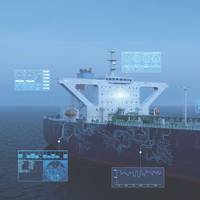
Siloed data systems represent a “recipe for duplicative and multiplicative cost inside a company and across companies”, an OrbitMI-hosted panel at the recent Shipping Insight event in the US was told, as a Bureau Veritas-backed study highlighted this as a big barrier to data collaboration for digitalization of shipping to cut emissions.Vast amounts of data are generated from ship operations - such as from sensors onboard or vessel performance management systems - as well as from…
ABS Launches "My DigitalFleet" for Marine and Offshore Operators

One of the world's largest maritime classification societies American Bureau of Shipping (ABS) on Tuesday launched a web-based digital platform that "delivers real-time data-driven insights to improve fleet efficiency, reduce costs and help manage risks," for marine and offshore operators.The platform, called My DigitalFleet, is, according to ABS, a significant step forward for the digitalization of the maritime industry.Christopher J. Wiernicki, ABS Chairman, President, and CEO, said, "Digitalization is the key enabler for asset management, sustainability and regulatory compliance strategies.
ClassNK Certification for SMARTSHIP

ClassNK confirmed type approval certification for SMARTShip, a patented digital shipping solution developed by Alpha Ori Technologies (AOT).SMARTShip, an Internet of Things (IoT) platform that enables the onboard operation of multiple systems with varying degrees of autonomy, has already been installed on more than 30 vessels, with another 60 ships are at various stages of the set-up process.ClassNK’s certification for SMARTShip approves the solution as a ‘Computer Based System’ which conforms to the Class Society’s rules governing a product performing ‘Remote Monitoring and Diagnostics’…
StormGeo Acquires Nautisk
Weather intelligence and decision support services provider StormGeo has entered into an agreement to acquire Nautisk, a global supplier of maritime charts and publications to the merchant marine from NHST Media Group. The combination allows StormGeo to integrate routing and weather services with its charts and publications solutions.According to Per-Olof Schroeder, CEO of StormGeo, “The acquisition of Nautisk is a natural complement to our existing solutions to the global shipping industry. In recent years, Nautisk has developed state-of-the-art software for use in planning and navigation, while maintaining one of the industry’s best run operations for delivering paper charts and publications to vessels worldwide.
Maritime's Digital Transformation & Simulation-based Training
Nearly 200 delegates from across the world gathered in Den Haag, The Netherlands in September 2017 to hear about the latest developments in maritime training based on state-of-the-art simulation technology. The three-day Kongsberg UC2017 International Maritime Simulation User Conference brought attendees up to date on developments in digitalization, maritime training, navigation technology, maritime operations simulation and the use of virtual reality in training. Tom Mulligan reports.
All in a Day’s Walk
Just over the horizon, a new ‘Integration Strategy’ promises offshore safety and efficiencies. Kongsberg’s Walk-to-Work technology is just the beginning. Maritime technology has come on in leaps and bounds since the turn of the century. We have the technology to keep an offshore support vessel on station within a 0.5-meter radius, even in the most severe weather conditions and sea states. We have the technology to manage power output, and control drives and thrusters to the ‘nth’ degree, providing safety and reliability for all ship handling operations. And we have the technology to deliver gigabytes of data to shore without paying for a helicopter or a mid-ocean drop off of hard drives or DVDs. So, what’s next? Arguably, the ‘big’ topic is unmanned vessels.
Royal Arctic Line Integrates Navis N4 to Modernize Operations
Navis and Royal Arctic Line Denmark (RAL) announced that the terminal has gone live with the Navis N4 terminal system. Lacking key features in its legacy system with multiple disparate systems in place to support complex operations, RAL sought out Navis’ expertise to help align and streamline business processes via N4. RAL is a key player among the Nordic countries, serving as the only container terminal in northern Denmark and the only service provider to all of Greenland. As the sole provider along these shipping lanes, RAL’s reasons for implementing N4 are twofold – to update to a more modern platform to better service all of its current customers and as the first step in its planned expansion into increasingly competitive markets.
Ericsson Maritime Platform Targets Shipping Connectivity
To tap the potential of shipping industry, Ericsson launched its Maritime ICT Cloud platform designed to provide an end-to-end solution targeting connectivity and tracking needs for the maritime industry. The Swedish telecom giant Ericsson launched Maritime ICT Cloud services for the shipping industry. Maritime ICT Cloud includes a communication platform with optimized connectivity and bandwidth for different types of traffic. The "Maritime ICT Cloud”, mainly supporting logistical operations, as well as connecting vessels at sea with shore-based operations, maintenance service providers, customer support centres, fleet/transportation partners, port operations and authorities. There are also tools for voyage optimization, cargo monitoring and crew welfare.
MTN Broadband Coverage Expanding
After launching its Terrestrial Broadband Network (TBN) just more than one year ago, MTN Communications (MTN) announces the number of TBN-connected cruise ships has doubled and covered regions have tripled. Since the MTN TBN kick-off in Alaska in the Summer 2013 cruise season, several MTN partners, including Norwegian Cruise Line and Princess Cruises, are leveraging this new technology to enrich their passenger and crew communications experience. Thanks in part to this new technology, the MTN hybrid network now delivers approximately 10 Terabytes of data daily.
Standardization for Safer Shipping of e-Navigation & Training

e-Navigation aims to harmonize navigation systems and ultimately make the mariners’ job easier, but its implementation will necessitate extensive changes to maritime training. Dr. Michael Baldauf of the World Maritime University, discusses the reasons for change, progress made so far, and further changes that will need to be made to reap the benefits of e-Navigation. In recent years, bridges have become increasingly ‘smart’ with a plethora of new equipment, systems and interfaces.
NOAA Begins Production With Esri

GIS Creates Integrated Data Workflow for More Efficient Chart Production. The National Oceanic and Atmospheric Administration (NOAA) has implemented a new nautical charting system based on Esri GIS technology to produce more navigational products than ever before without increasing its budget or personnel needs. The new system, NCS II, is based on Esri Nautical Solution, and it allows NOAA to centralize the management of hydrographic data for US coastal waters. Since accepting Esri Nautical Solution as part of its production system in 2009…
Fleet Management System Using Google Earth
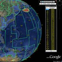
Applied Weather Technology, Inc. (AWT), announced the worldwide launch of GlobalView, an innovative new fleet management system that combines AWT’s industry-leading ship routing services and software with Google Earth technology to give fleet managers a more visual, easy-to-use and powerful system for enhancing the safety of ships and crew, reducing fuel consumption and curbing carbon emissions. “We believe GlobalView to be the first fleet management system to utilize Google Earth technology—this brings a significant innovation to ship routing technology…


