

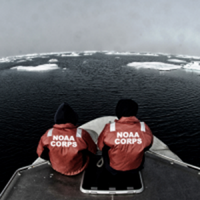
NOAA to Boost Arctic Nautical Charting
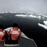
NOAA plans increased 2015 Arctic nautical charting operations, coordinating with U.S. As commercial shipping traffic increases in the Arctic, NOAA informs it is taking steps to update nautical charts in the region. NOAA’s Office of Coast Survey will use data collected by two of its own ships, Rainier and Fairweather, as well as the U.S. Coast Guard cutter Healy and a private sector hydrographic contractor to cover nearly 12,000 nautical miles in the Arctic for use in updating its navigational charts.
DEA’s New 82-foot Survey Vessel Commissioned
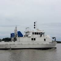
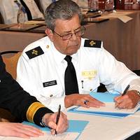
David Evans and Associates, Inc.’s Marine Services Division commissioned its new 82-foot hydrographic survey and scientific vessel Blake in a ceremony held in the vessel’s homeport of Gulfport, Mississippi. At the ceremony, U.S. Senator Thad Cochran of Mississippi broke a Champagne bottle across the Blake’s bow. In addition to remarks by the Senator, Rear Admiral Gerd Glang, the director of the National Oceanic and Atmospheric Administration’s Office of Coast Survey and the U.S. National Hydrographer, and Mayor of Gulfport William Gardner Hewes spoke to attendees.
Nautical Chart Updated for Charleston Harbor
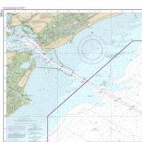
The new nautical chart 11525 extends eastward, to cover an additional pilot boarding area for vessels headed to the Charleston Harbor. Ships entering the Port of Charleston will have a new and improved nautical chart that covers a larger area to ensure safer navigational approaches into the harbor. Available on the 4th of July, new chart 11525 (Charleston Harbor Entrance and Approach) replaces the old chart 11523 (Charleston Harbor Entrance). It expands chart coverage further east, covering an additional 345 square nautical miles that wasn’t on the old chart.
NOAA Certifies 11Printers for Paper Charts
Mariners and the boating public have a wider choice of options and special services when they purchase NOAA paper nautical charts, thanks to NOAA's expanded "print-on-demand" chart production and distribution system. Coast Survey has certified eleven chart printing agents who have the flexibility to offer different color palettes, various papers, a cleaner margin, and a range of services. Under the program, NOAA's paper nautical charts are printed when the customer orders them - or "on demand." NOAA creates and maintains the charts…
NOAA Begins Hydrographic Survey Season
New data will update nautical charts around the country. As sure as spring arrives, NOAA vessels and independent contractors are hitting the seas for the nation's 180th hydrographic surveying season, collecting data for over two thousand square nautical miles in high-traffic U.S. coastal waters. "Nautical charts are the foundation for the nation's maritime economy, and NOAA hydrographers spend months at sea, surveying critical areas to ensure safe navigation for the shipping, fishing, and boating communities," said Rear Admiral Gerd Glang, director of the Office of Coast Survey.
NOAA's Paper Charts are here to Stay
It won't be long before mariners and the boating public will have a wider choice of options and special services when they purchase NOAA paper nautical charts, thanks to NOAA's expanded "print-on-demand" chart production and distribution system, Coast Survey officials announced today. This week, Coast Survey certified new print-on-demand chart printing agents, and gave them the flexibility to offer different color palettes, various papers, a cleaner margin, and a range of services.
NOAA Nautical Charts Now Permanently Free

After a three-month trial period, PDF versions of NOAA nautical charts will become a permanent product, free to the public. The free PDFs, which are digital images of traditional nautical charts, are especially valued by recreational boaters who use them to plan sailing routes and fishing trips. The free PDF charts are part of a suite of new and enhanced navigational products designed to make NOAA’s data more accessible to the general public. “Up to date charts help boaters avoid groundings and other dangers to navigation…
Coast Survey to Resove Magenta Line Issues
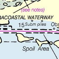
The Office of Coast Survey has announced that future editions of nautical charts of the Intracoastal Waterway will be updated to include an improved "magenta line" that has historically aided navigation down the East Coast and around the Gulf Coast. Additionally, Coast Survey will change the magenta line's function, from the perceived "recommended route" established more than a hundred years ago, to an advisory directional guide that helps prevent boaters from going astray in the maze of channels that comprise the route.
NOAA Updates New York Harbor Charts Post-Sandy
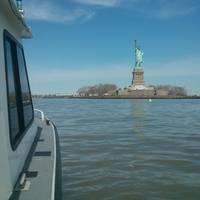
Ships, barges, ferries, and recreational boats in the busy New York Harbor will be able to navigate more safely thanks to an updated version of the harbor’s nautical chart recently issued by NOAA that includes data gathered in the navigational response to the damage caused by Sandy in October 2012. The latest edition of Chart 12334 – New York Harbor includes new depth measurements and shoreline depictions. “This new chart edition is the first product of a multi-year post-Sandy charting plan,” said Rear Admiral Gerd Glang, director of NOAA’s Office of Coast Survey.
NOAA: End of Traditional Paper Nautical Charts
NOAA’s Office of Coast Survey, which creates and maintains the nation’s suite of over a thousand nautical charts of U.S. coastal waters, announced major changes ahead for mariners and others who use nautical charts. Starting April 13, the federal government will no longer print traditional lithographic (paper) nautical charts, but will continue to provide other forms of nautical charts, including print on demand charts and versions for electronic charting systems. “Like most other mariners…
Death Knell for NOAA Traditional Paper Nautical Charts
NOAA’s Office of Coast Survey has announced major changes ahead for mariners and others who use nautical charts. Starting April 13, 2014, the federal government will no longer print traditional lithographic (paper) nautical charts . NOAA will continue to provide other forms of nautical charts, including Print-on-Demand paper charts as well as electronic and digital formats. Since 1862, those lithographic nautical charts -- available in marine shops and other stores -- have been printed by the U.S. government and sold to the public by commercial vendors.
NOAA Finds Lost 19th Century U.S. Coast Survey Steamer
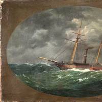
More than 153 years after it was lost in a violent collision at sea, government and university maritime archaeologists have identified the wreck of the ship Robert J. Walker, a steamer that served in the U.S. Coast Survey, a predecessor agency of NOAA. The Walker, while now largely forgotten, served a vital role as a survey ship, charting the Gulf Coast ‒ including Mobile Bay and the Florida Keys ‒ in the decade before the Civil War. It also conducted early work plotting the movement of the Gulf Stream along the Atlantic Coast.
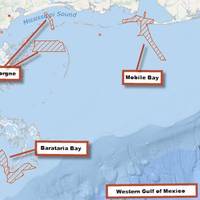
NOAA’s Coast Survey Plans for New Arctic Nautical Charts
Less sea ice and more ship traffic means new charts needed for safety. NOAA’s Office of Coast Survey has issued an updated Arctic Nautical Charting Plan, as a major effort to improve inadequate chart coverage for Arctic areas experiencing increasing vessel traffic due to ice diminishment. The update came after consultations with maritime interests and the public, as well as with other federal, state, and local agencies. “As multi-year sea ice continues to disappear, vessel traffic in the Arctic is on the rise,” said Rear Admiral Gerd Glang, NOAA Coast Survey director.
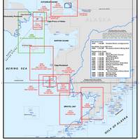
Arctic Nautical Charts: NOAA Plans Updates
Less sea ice and more ship traffic means new charts needed for safety. NOAA’s Office of Coast Survey has issued an updated Arctic Nautical Charting Plan , as a major effort to improve inadequate chart coverage for Arctic areas experiencing increasing vessel traffic due to ice diminishment. NOAA plans to create 14 new charts to complement the existing chart coverage. For example, seven of the charts will complete chart coverage from the Alaska Peninsula to Cape Lisburne at the edge of the North Slope…
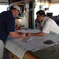
NOAA & US Power Squadrons Sign Agreement
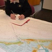
NOAA’s Office of Coast Survey & US Power Squadrons sign a Memorandum of Agreement to improve cooperative charting program. Rear Adm. Gerd Glang, director of NOAA’s Office of Coast Survey, recently sat down with John Alter, chief commander of the U.S. Power Squadrons (USPS) to sign up to a collaboration that began fifty years ago. The USPS is a nonprofit organization dedicated to safe boating through instruction in seamanship, navigation, and related subjects. With nearly 40,000 members in more than 400 squadrons across the U.S.
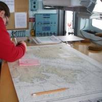
NOAA and U.S. Power Squadrons Renew Program
This week, NOAA and the U.S. Power Squadrons, a non-profit organization dedicated to safe boating, will renew a 50-year commitment to a cooperative charting program that helps to update the nation's thousands of navigational charts. Under the voluntary program, formalized by a Memorandum of Agreement, members of the U.S. Power Squadrons scan water and land areas, looking for changing conditions that may not be reflected on NOAA nautical charts. Power Squadrons members submit their reports online, and NOAA cartographers review and incorporate changes to their navigation products. "The partnership between Coast Survey and the Power Squadrons is a long and successful one, speaking to our shared vision of safety on U.S.


