

NOAA Continues Transition to Electronic Navigational Charts
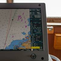
NOAA is continuing with the sunset plan for paper and raster nautical charts in August and September. A set of 15 charts covering the eastern half of the North Slope of Alaska will be moved into last edition status on August 5, 2021 and will be canceled on February 2, 2022. Another set of 14 charts covering the western half of the North Slope will be moved into last edition status on September 2, 2021 and be cancelled on March 2, 2022.This set of charts has been fully supplanted by new electronic charts as part of NOAA’s Office of Coast Survey Raster Sunset Plan…
US Agencies Ink MOU for Hawaii Emergency Harbor Assessments
The U.S. Coast Guard signed a memorandum of understanding in June with the National Oceanic and Atmospheric Administration Office of Coast Survey, State of Hawaii Department of Transportation, and United States Army Corps of Engineers regarding maritime emergency harbor assessments within federal waterways in Hawaii.This agreement means the partners can work more efficiently and effectively to assess the State's harbors following disasters, such as severe weather events, to restore…
New Members Join NOAA’s Hydrographic Services Advisory Panel

NOAA acting administrator retired Navy Rear Adm. Tim Gallaudet, Ph.D., has appointed three new members to the Hydrographic Services Review Panel, a federal advisory committee that gives NOAA independent advice for improving a range of services and products that support safe navigation and coastal resilience. Sean M. Duffy Sr., executive director, Big River Coalition, New Orleans, La. Retired USCG Capt. Julie Thomas, senior advisor, Southern California, Coastal Ocean Observing System, Scripps Institution of Oceanography, La Jolla, Calif.
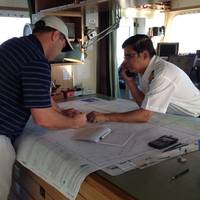
Coast Guard, NOAA to Include Navigation Rules in U.S. Coast Pilot

The U.S. Coast Guard and National Oceanic and Atmospheric Administration (NOAA) have teamed up on a consolidated publication that will help mariners save time and money. The Coast Guard Office of Navigation Systems and NOAA Office of Coast Survey will incorporate the amalgamated International Regulations for the Prevention of Collisions at Sea (72 COLREGS) and the Inland Navigation Rules into NOAA’s U.S. Coast Pilot publications. The U.S. Coast Pilot publications already include the Coast Guard’s Vessel Traffic Service regulations.
Missing Tugboat Found after 95 Years
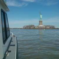
The USS Conestoga (AT 54) mysteriously vanished without a distress call nearly 100 years ago, with 56 officers and sailors on board. The nation was gripped by the puzzling disappearance. Now, NOAA and the U.S. Navy announced the Navy seagoing fleet tugboat has been found in the Greater Farallones National Marine Sanctuary off San Francisco, 95 years after its disappearance. Conestoga left San Francisco on March 25, 1921 en route to Tutuila, American Samoa via Pearl Harbor, Hawaii, but never reached its destination.
Cuba, US Sign Memorandum on Maritime Navigation
Representatives of Cuba and the United States signed in Havana a memorandum of understanding (MoU) on cooperation in areas of hydrography and geodesy to improve the safety of maritime navigation. Ambassador Jeffrey DeLaurentis, the Chief of Mission at the U.S. Embassy in Havana, and Col. Candido Alfredo Regalado Gomez, Chief of Cuba’s National Office of Hydrography and Geodesy (ONHG), have signed the MoU. “NOAA (National Oceanic and Atmospheric Administration) has a strong interest in both improving navigational safety and in protecting the marine environment in the heavily travelled and vibrant waters between our two countries in the Straits of Florida,” said Russell Callender, Ph.D., assistant NOAA administrator for the National Ocean Service.
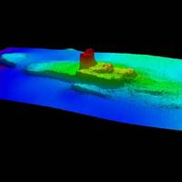
Remains of Lost 1800s Whaling Fleet Found
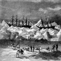
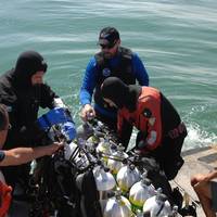
NOAA archaeologists have discovered the battered hulls of two 1800s whaling ships nearly 144 years after they and 31 others sank off the Arctic coast of Alaska in one of the planet's most unexplored ocean regions. The shipwrecks, and parts of other ships, that were found are most likely the remains of 33 ships trapped by pack ice close to the Alaskan Arctic shore in September 1871. The whaling captains had counted on a wind shift from the east to drive the ice out to sea as it had always done in years past.
NOAA Deploys Survey Ships for Arctic Charting Projects
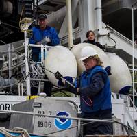
NOAA announced the official launch of its 2015 Arctic hydrographic survey season took place this morning, in Kodiak, Alaska, in a World Ocean Day ceremony which showcased the deployment of the NOAA ships Rainier and Fairweather. “Most Arctic waters that are charted were surveyed with obsolete technology, with some of the information dating back to Captain Cook's voyages, long before the region was part of the United States,” said NOAA deputy under secretary for operations Vice Admiral Michael S. Devany in remarks directed to the crews of NOAA ships.
NOAA to Boost Arctic Nautical Charting
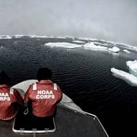
NOAA plans increased 2015 Arctic nautical charting operations, coordinating with U.S. As commercial shipping traffic increases in the Arctic, NOAA informs it is taking steps to update nautical charts in the region. NOAA’s Office of Coast Survey will use data collected by two of its own ships, Rainier and Fairweather, as well as the U.S. Coast Guard cutter Healy and a private sector hydrographic contractor to cover nearly 12,000 nautical miles in the Arctic for use in updating its navigational charts.
Nautical Chart Updated for Charleston Harbor
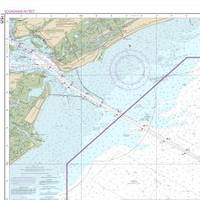
The new nautical chart 11525 extends eastward, to cover an additional pilot boarding area for vessels headed to the Charleston Harbor. Ships entering the Port of Charleston will have a new and improved nautical chart that covers a larger area to ensure safer navigational approaches into the harbor. Available on the 4th of July, new chart 11525 (Charleston Harbor Entrance and Approach) replaces the old chart 11523 (Charleston Harbor Entrance). It expands chart coverage further east, covering an additional 345 square nautical miles that wasn’t on the old chart.
NOAA Certifies 11Printers for Paper Charts
Mariners and the boating public have a wider choice of options and special services when they purchase NOAA paper nautical charts, thanks to NOAA's expanded "print-on-demand" chart production and distribution system. Coast Survey has certified eleven chart printing agents who have the flexibility to offer different color palettes, various papers, a cleaner margin, and a range of services. Under the program, NOAA's paper nautical charts are printed when the customer orders them - or "on demand." NOAA creates and maintains the charts…
19th Century Shipwreck Found off Golden Gate Bridge
NOAA announced it has found the underwater wreck of the passenger steamer City of Chester, which sank in 1888 in a collision in dense fog near where the Golden Gate Bridge stands today. The announcement was made during a press event at Gulf of Farallones National Marine Sanctuary’s San Francisco headquarters at Crissy Field. NOAA’s predecessor agency first located ship in 1890, two years after it sank. The story of City of Chester will be shared with the public in a future waterfront exhibit NOAA will place at the sanctuary office at Crissy Field. The office is the former U.S.
NOAA Certifies More Printing Agents
The availability of paper "print-on-demand" nautical charts continues to expand, as NOAA's Office of Coast Survey has added three more printing companies to its roster of certified agents for paper charts. "The most recent printers to join the NOAA paper chart program represent the enduring connections between maritime tradition and progress," said Capt. Shep Smith, chief of Coast Survey's Marine Chart Division. "Companies with histories going back decades, and even centuries, support a firm foundation for the continuing production and delivery of U.S. Iver C. Weilbach & Co.
NOAA's Paper Charts are here to Stay
It won't be long before mariners and the boating public will have a wider choice of options and special services when they purchase NOAA paper nautical charts, thanks to NOAA's expanded "print-on-demand" chart production and distribution system, Coast Survey officials announced today. This week, Coast Survey certified new print-on-demand chart printing agents, and gave them the flexibility to offer different color palettes, various papers, a cleaner margin, and a range of services.
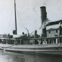
Walker Wreck Added to Historic Places Register
NOAA announced that the wreck of the ship USCS Robert J. Walker, a steamer that served in the U.S. Coast Survey, a predecessor agency of NOAA’s Office of Coast Survey, has been added to the National Register of Historic Places. The Walker served as survey ship, charting the Gulf Coast ‒ including Mobile Bay and the Florida Keys ‒ in the decade before the Civil War. It also conducted early work plotting the movement of the Gulf Stream along the Atlantic Coast. Twenty-one men died when Walker sank in rough seas in the early morning hours of June 21…
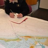
NOAA Nautical Charts Now Permanently Free

After a three-month trial period, PDF versions of NOAA nautical charts will become a permanent product, free to the public. The free PDFs, which are digital images of traditional nautical charts, are especially valued by recreational boaters who use them to plan sailing routes and fishing trips. The free PDF charts are part of a suite of new and enhanced navigational products designed to make NOAA’s data more accessible to the general public. “Up to date charts help boaters avoid groundings and other dangers to navigation…
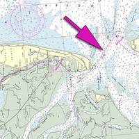
NOAA Updates New York Harbor Charts Post-Sandy
Ships, barges, ferries, and recreational boats in the busy New York Harbor will be able to navigate more safely thanks to an updated version of the harbor’s nautical chart recently issued by NOAA that includes data gathered in the navigational response to the damage caused by Sandy in October 2012. The latest edition of Chart 12334 – New York Harbor includes new depth measurements and shoreline depictions. “This new chart edition is the first product of a multi-year post-Sandy charting plan,” said Rear Admiral Gerd Glang, director of NOAA’s Office of Coast Survey.
Tell NOAA If You Think the IWR Still Needs the 'Magenta Route'
If you are a recreational boater, fisherman, or another member of the maritime community, NOAA's Office of Coast Survey wants to pick your brain about the "magenta line," which historically depicted the recommended route for the Intracoastal Waterway Route (IWR) on NOAA nautical charts. A recent Federal Register Notice outlines NOAA's options for improving the accuracy of the magenta line, which is presently being removed from new editions of nautical charts. Federal funding does not allow for consistent maintenance of the 3…
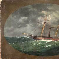
Subsea Wreck Identifed Off NJ Coast 153 Years On
Lost after a violent collision at sea, government and university maritime archaeologists have identified the wreck of the ship 'Robert J. Walker', a steamer that served in the U.S. Coast Survey, a predecessor agency of NOAA. Twenty sailors died when the Walker sank in rough seas in the early morning hours of June 21, 1860, ten miles off Absecon Inlet on the New Jersey coast. The crew had finished its latest surveys in the Gulf of Mexico and was sailing to New York when the Walker was hit by a commercial schooner off New Jersey.
NOAA Finds Lost 19th Century U.S. Coast Survey Steamer

More than 153 years after it was lost in a violent collision at sea, government and university maritime archaeologists have identified the wreck of the ship Robert J. Walker, a steamer that served in the U.S. Coast Survey, a predecessor agency of NOAA. The Walker, while now largely forgotten, served a vital role as a survey ship, charting the Gulf Coast ‒ including Mobile Bay and the Florida Keys ‒ in the decade before the Civil War. It also conducted early work plotting the movement of the Gulf Stream along the Atlantic Coast.
NOAA Updates Cobscook Bay Area Chart
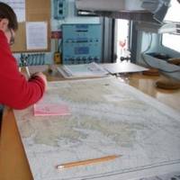
Northern Maine vessels will be able to navigate more safely around the dangerous Cobscook Bay thanks to an updated version of the area's nautical chart issued by NOAA. The latest chart includes a new detailed illustration-called a "chart inset"-of the waters around Falls Island, providing safer passage for mariners who transit those waters. While NOAA cartographers had updated Chart 13394 (Grand Manan Channel) over the past several years, using depth measurements and obstruction locations acquired during a major hydrographic survey in 2010, a new inset was needed specifically for Falls Island. "Larger, more detailed scale coverage helps mitigate the dangers to navigation in these areas," explained Cmdr. Shep Smith, chief of NOAA Office of Coast Survey's Marine Chart Division.
Death Knell for NOAA Traditional Paper Nautical Charts
NOAA’s Office of Coast Survey has announced major changes ahead for mariners and others who use nautical charts. Starting April 13, 2014, the federal government will no longer print traditional lithographic (paper) nautical charts . NOAA will continue to provide other forms of nautical charts, including Print-on-Demand paper charts as well as electronic and digital formats. Since 1862, those lithographic nautical charts -- available in marine shops and other stores -- have been printed by the U.S. government and sold to the public by commercial vendors.
NOAA: End of Traditional Paper Nautical Charts
NOAA’s Office of Coast Survey, which creates and maintains the nation’s suite of over a thousand nautical charts of U.S. coastal waters, announced major changes ahead for mariners and others who use nautical charts. Starting April 13, the federal government will no longer print traditional lithographic (paper) nautical charts, but will continue to provide other forms of nautical charts, including print on demand charts and versions for electronic charting systems. “Like most other mariners…


