

Weather Data Gathering Project Underway for US Offshore Wind
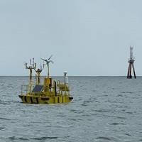
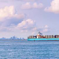
The U.S. Department of Energy (DOE) and the National Oceanic and Atmospheric Administration (NOAA) have launched an 18-month initiative to gather extensive weather, ocean, and wildlife data near the sites of active offshore wind farms and lease areas off the coast of the Northeast United States.This effort, which is part of the third phase of the Wind Forecast Improvement Project (WFIP3), seeks to gather high-quality data to improve the design and operation of offshore wind turbines and wind farms.
Wreck of WWII-era Cargo Ship Found in the Great Lakes
The wreck of a World War II-era freighter has been discovered in over 600 feet of water around 35 miles north of Michigan’s Keweenaw Peninsula.Over the last 7 years, shipwreck researcher Dan Fountain has been studying remote sensing data in the search for shipwrecks in Lake Superior. After coming across a particularly deep anomaly, he reached out to the Great Lakes Shipwreck Historical Society (GLSHS) for help in identifying the potential wreck. In 2023 GLSHS Director of Marine Operations…
NOMARS Puts New Officers in Charge
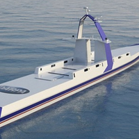
DARPA’s NOMARS program aims to revolutionize naval operations by designing a ship that can operate autonomously for extended periods at sea without an onboard crew.One project at the forefront of maritime innovation is the development of a vessel called “Defiant,” a project of the Defense Advanced Research Projects Agency (DARPA). The Defiant is referred to as a NOMARS vessel – “No Manning Required Ship.”The project’s been underway at least since January 2020, when DARPA held a “proposers day…
COP28: US Cracking Down on Methane from Oil and Gas

The Biden administration on Saturday unveiled final rules aimed at cracking down on US oil and gas industry releases of methane, part of a global plan to rein in emissions that contribute to climate change.The rules, two years in the making, were announced by US officials at the United Nations COP28 climate change conference in Dubai. The US and other nations attending the summit are expected to detail how they will achieve a 150-country pledge made two years ago to slash methane emissions by 30% from 2020 levels by 2030.Methane tends to leak into the atmosphere undetected from drill sites…
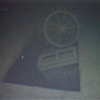
Wreck Site Identified as WWII Carrier USS Ommaney Bay (CVE 79)
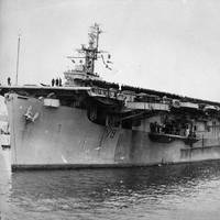
Naval History and Heritage Command confirmed the identity of a wreck site as USS Ommaney Bay (CVE 79) July 10. While operating in the Sulu Sea, Ommaney Bay was hit and eventually mortally wounded by a twin-engine Japanese suicide plane on Jan. 4, 1945.NHHC’s Underwater Archaeology Branch used a combination of survey information provided by the Sea Scan Survey team and video footage provided by the DPT Scuba dive team, to confirm the identity of Ommaney Bay. This information correlated with location data for the wreck site provided to NHHC in 2019 by Vulcan…
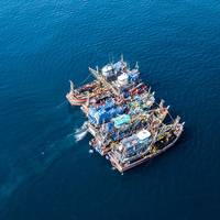
Tech File: A Robotic Reach in Offshore Wind
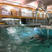
With a background in subsea and offshore, coming up with new ideas is the norm’ for UK-based engineering consultancy STL (Submarine Technology Limited), writes Elaine Maslin.The last few years have been no different. The company has been focusing on ship-based robotics, including robotic arms. These aren’t just any robotic arms – they’re motion compensated systems for deploying/recovering people and robots to and from fixed or moving objects. That could be wind technicians to…
NOAA Hires Fugro to Monitor Shoreline Changes in Texas, Louisiana
The National Oceanic and Atmospheric Administration (NOAA) has awarded Fugro two mapping projects on the US Gulf Coast to monitor and quantify shoreline change in this flood-prone region.The projects, located in Texas and Louisiana, are underway and were awarded under an existing indefinite delivery indefinite quality (IDIQ) contract to support the agency’s Coastal Mapping Program. Geo-data deliverables are scheduled for Q3 2023 and will be integrated into the national shoreline dataset…
A Robotic Reach in Offshore Wind

With a background in subsea and offshore, coming up with new ideas is the norm for UK-based engineering consultancy STL (Submarine Technology Limited), writes Elaine Maslin.The last few years have been no different. The company has been focusing on ship-based robotics, including robotic arms. These aren’t just any robotic arms – they’re motion-compensated systems for deploying/recovering people and robots to and from fixed or moving objects.That could be wind technicians to an…
Maritime Communications: Easier, Faster, Cheaper
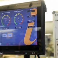
In November 2021, GTMaritime published a white paper: “Maritime Communications - A look over the horizon.” The report, available here, is built around three broad Sections – 1. “Basics of marine Communications;” 2. “The connected ship;” and 3. “Special services.”Then, each Section presents a closer look at various topics. The “Basics” section, for example, covers regulatory issues established by IMO treaties and national agencies. It presents the terms and concepts that define satellite systems and networks…
Seismic Data Firm CGG Launches Pollution Monitoring Solution
French firm CGG, best known for its seismic data services for oil and gas exploration, has now launched a maritime pollution monitoring solution named SeaScope."Combining expertise in remote sensing science, Earth observation data, machine learning and high-performance computing, SeaScope provides critical sea surface slick intelligence for a range of industries to strengthen situational awareness of the interaction between offshore assets, coastal facilities, local vessel activity and the natural marine environment…
Satellites Expose Risks of Forced Labor in Global Fishing
Fishing vessels with crews of forced laborers behave in systematically different ways to the rest of the global fleet, according to a study purporting to be the first to remotely identify vessels potentially engaged in modern slavery.Using satellite data, machine learning and on-the-ground expertise from human rights practitioners, U.S. researchers found up to 26% of about 16,000 industrial fishing vessels analyzed were at high risk of using forced labor.As many as 100,000 people are estimated to work on these high-risk vessels, many of whom are potential victims of forced labor.
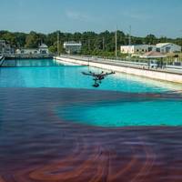
ARA Taps Coolbaugh as Ohmsett Facility Manager

Applied Research Associates, Inc. (ARA) announced Dr. Tom Coolbaugh has joined the team as the Program/Facility Manager for Ohmsett – The National Oil Spill Response Research & Renewable Energy Test Facility. He will have oversight of the day-to-day operations, maintenance and testing at the facility, while ensuring facility users’ needs are met.Dr. Coolbaugh recently retired after 32 years with ExxonMobil Corporation, most recently as the Technology and Advocacy Advisor in the Emergency Preparedness and Response organization.
LADAR: Laser Sensor Technology for the Maritime Industry
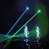
Research scientist and entrepreneur Sverre Dokken believes laser-based remote sensing has big potential in the maritime domain. But what is LADAR, who’s it for and what are the key benefits?“Our mission is to be the world leader in innovative maritime sensor products that enhance the safety and security of shipping and all manner of offshore activity,” says Ladar Ltd (LDR) principal Sverre Dokken.In the sensor vanguardEssentially a laser-based navigational aid, LADAR (Laser Detection and Ranging) combines long-distance object detection with high-accuracy measurement…
Global Reef Expedition: Mission to Tonga

Assessing the health of coral reefs in the Kingdom of TongaHealthy coral reefs provide critical ecosystem services for millions of people globally, but with climate change and anthropogenic stressors, the landscape of these habitats is regularly shifting. The science and conservation community has realized the importance of baseline studies to help track how these precious reef ecosystems are changing. The Khaled bin Sultan Living Oceans Foundation launched the Global Reef Expedition…
USCG Arctic Satellites aim to Add Margin of Safety

The U.S. Coast Guard’s mission of keeping the seas safe will soon get an additional boost from space with two polar satellites. The two satellites, called “cube satellites” or “cubesats” for their small size of about 60 square centimeters, or a little under 2 feet, will be part of a payload on a SpaceX Falcon 9 rocket scheduled to launch from Vandenberg Air Force Base in California Nov. 28. Although the Coast Guard has used satellite technology for years, these two are the first to be entirely dedicated to a Coast Guard mission. The initiative is part of the U.S.
GPS, Ice Profiling Sonar Used in Sea Level Variation Study
ASL Environmental Sciences said that Dr. David Holland of New York University, in collaboraon with Dr. Natalya Gomez at McGill University, is leading an invesgaon of sea level variaons in the Disko Bay region of western Greenland.According to a statement from the company with over 40 years of experience in oceanographic, acoustic, remote sensing and ice research products and scientific consulting services, a shore-based system compares the direct arrival of GPS signals to the signals reflected off the sea surface to obtain sea level.The presence of sea ice and icebergs complicate the measurements. A shore-mounted camera provides information…
UK Satellites Launched to Track Illegal Shipping Activity
Surrey Satellite Technology Ltd (SSTL) has confirmed the successful launch of two satellites, NovaSAR-1, a Synthetic Aperture Radar (SAR) satellite, and SSTL S1-4, a high resolution optical Earth Observation satellite. The two satellites were launched into a 580km sun-synchronous orbit on board the PSLV launch vehicle from the Satish Dhawan Space Centre in Sriharikota, India on 16 September at UTC 16:38 by Antrix Corporation Limited, the commercial arm of the Indian Space Research Organisation.Sir Martin Sweeting, Executive Chairman of SSTL, said “I am pleased to confirm that successful contact has been made with both satellites and they are in good health.
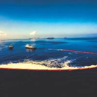
New Oil Spill Tech Solutions Put to the Test
No two oil spill response operations are the same. Each can present new and even tougher challenges for spill responders as they detect, contain and recover spilled oil. Diverse aspects affecting oil spill response operations can be the physical environment, spill monitoring, use of chemical dispersants, and the availability of proper technology for the situation.Some challenges have been met through research and technology development of techniques for dealing with spills. However…
Spill Prevention & Response: Old Lessons, New Challenges
Emerging spill response trends fit into two big categories: technology and a combination of economic and social forces. Both will shape what comes next.Florida’s stunning Tampa Bay stands out as exactly the kind of place where you have to think about hazardous materials emergencies. It was 25 years ago, on August 10, 1993, that a freighter collided with two barges near the entrance of Tampa Bay, causing a fire and spilling over 32,000 gallons of jet fuel, diesel, and gasoline and about 330,000 gallons of heavy fuel, devastating beaches, wildlife and habitat.
Data is the New Oil and Satellites Are the Pipeline
As the shipping industry embraces digitalization, it’s time for a new era of fresh thinking that recognizes the potential of satellite communications in delivering financial, environmental and safety improvements. If shipping awarded a ‘word of the year’ in 2017, digitalization would have been a clear contender. The term has become a mainstay of commentary in maritime media and a key topic of debate at our industry’s conferences and exhibitions. But the reality is that digitalization is more than just a word or catchphrase that’s captured shipping’s attention.
Rolls-Royce rolls out Sophisticated Situational Awareness for Navigators
Rolls-Royce has unveiled a sophisticated situational awareness system that fuses multiple sensors with intelligent software to mitigate against the safety risks navigators face when operating vessels at night, in adverse weather conditions or in congested waterways. Officially introduced today during the Seatrade Cruise Global event in Fort Lauderdale, USA, the Rolls-Royce Intelligent Awareness (IA) system is the first of its kind to be made commercially available that uses data collection to enhance navigational safety and operational efficiency. Iiro Lindborg, Rolls-Royce, General Manager, Remote & Autonomous Operations, said: “The IA system forms part of our ongoing development of the autonomous ship…
Ten Smart Ship Applications for an Intelligent Future
Ibna Zaman of Royston highlights the growing operational advantages provided by the effective analysis of intelligent data in the marine sector – if certain challenges can be successfully overcome. With the impending introduction of the EU MRV Regulations forcing shipping operators to think more seriously about monitoring, reporting and verifying fuel and emissions performance, new data driven improvements have the potential to transform the shipping sector. As its name implies…
BMT ARGOSS Launches Ice Charting Capability
BMT Group subsidiary BMT ARGOSS has launched its ice charting capability which will supplement its weather forecasting offering to provide a more enhanced and cost effective service to customers looking to harsh environments. Jean-Paul Lindeboom, Director of Metocean Weather Forecasting at BMT ARGOSS, said, “This combined capability under one roof is unique to the market. As part of this new capability, a number of BMT’s key senior meteorologists have completed an intensive training program at the Danish Meteorological Institute.


