

UK Funds Study on Navigation of Autonomous Ships
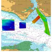
The United Kingdom Hydrographic Office (UKHO), a government agency has contributed to a new UK government-funded study on navigational requirements for autonomous maritime vessels.According to UKHO, it worked together with partner organisations L3 ASV and the Maritime and Coastguard Agency (MCA) to identify the future data requirements for autonomous shipping, and explore how navigational and wider geospatial data can be used to enable the safe navigation of smart and unmanned autonomous vessels.The study, funded by the Department for Transport’s Transport Technology Research Innovation Grant (T-TRIG), started by exploring the characteristics of current navigational data and charts in terms of what they comprise, their structure and how they are updated.
UKHO Supports HMS Queen Elizabeth in Portsmouth
The United Kingdom Hydrographic Office (UKHO) has supported the safe arrival of HMS Queen Elizabeth into Portsmouth by providing specialist marine geospatial and hydrographic expertise and data capabilities. Following initial dredging operations to make Portsmouth’s navigation channel and entrance deeper, hydrographic data was collected by the survey launch HMS Gleaner using modern multibeam echosounder technology to confirm the available water depth. As well as providing advice during data collection…
Most Cargo Ships Over 20,000 GT are ECDIS Ready -UKHO
Almost three-quarters of cargo ships over 20,000 gross tonnage (GT) are already compliant with the SOLAS-mandated Electronic Chart Display and Information System (ECDIS) deadline of July 1, 2017, according to the latest figures published by the United Kingdom Hydrographic Office (UKHO). The UKHO estimates that a further 3,828 cargo ships over 20,000 GT are yet to make the transition to using an ENC (Electronic Navigational Chart) service and therefore do not yet meet SOLAS (Safety of Life at Sea) regulations on ECDIS carriage.
C-MAP Appointed Admiralty Distributor
C-MAP has been appointed by the United Kingdom Hydrographic Office (UKHO) as an official ADMIRALTY Digital Distributor and SENC Service Provider. Following this appointment, C-MAP, will now supply ADMIRALTY Vector Chart Service (AVCS), C-MAP ADMIRALTY ENC Service (CAES), ADMIRALTY Digital Publications (ADP) and Electronic Nautical Publications (e-NPs) through its global network of offices and distributors. AVCS - the world’s leading ENC Service - will be provided by C-MAP in both traditional S-63 format and in the time and cost efficient DNV certified SENC data compression format. Named C-MAP ADMIRALTY ENC Service (CAES), the new service is complementary to other C-MAP services including Weather, Piracy and Professional+ (Pro+) chart data.
UKHO Brings ECDIS Seminars to North America
The United Kingdom Hydrographic Office (UKHO) will offer its free ‘Living with ECDIS’ seminars in Vancouver, Canada on Tuesday, November 29 and in Houston, U.S. on Thursday, December 1. Following on from the latest ECDIS usage figures, published earlier this year by the UKHO, which revealed that 59 percent of the global SOLAS fleet is now ECDIS-ready, the UKHO’s seminar is designed to ensure that the navigational benefits of ECDIS are achieved in an efficient and compliant manner.
New Port Approach Guides for Singapore
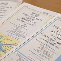
The United Kingdom Hydrographic Office (UKHO) has launched three new Port Approach Guides with the support of the Maritime and Port Authority of Singapore (MPA). Singapore is a major maritime hub for international and domestic ship owners and managers, and its port waters are among the busiest in the world. In 2015, vessel arrival tonnage reached 2.5 billion GT and approximately 1,000 ships can be found in the port of Singapore at any one time. In the same year, Singapore’s ports handled over 30.9 million TEUs of container throughput.
New Danelec ECDIS Includes UK AIO Service
The United Kingdom Hydrographic Office (UKHO) ADMIRALTY Information Overlay (AIO) is now available on Danelec Marine DM800 G2 Electronic Chart Display and Information Systems (ECDIS). AIO allows subscribers using the ADMIRALTY Vector Chart Service (AVCS) to view the latest temporary and preliminary notices to mariners as overlays on the ECDIS screen, as an aid to route planning and navigation. The AIO is displayed as a single layer on top of the basic Electronic Navigation Chart display. “AIO helps bridge crews identify areas of possible uncertainty and risk at the crucial planning stage,” said Thomas Mellor, UKHO head of OEM technical support and digital standards.
UKHO to Release Digital Charts for Expanded Panama Canal

The United Kingdom Hydrographic Office is to release five new Electronic Navigational Charts (ENCs) for the expanded Panama Canal. The new ENCS are produced by the Panama Canal Authority (PCA) and provide end-to-end coverage of the Canal at a scale of 1:10 000. They contain new survey data and up-to-date information for the expanded Canal, which will receive its first official transit on June 26. Jason Scholey, Senior Product Manager at the UKHO, commented: “The Panama Canal serves a vital purpose for international shipping and world trade.
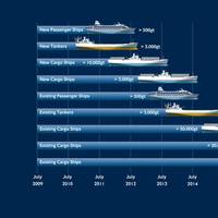
Majority of Global SOLAS Fleet is ECDIS Ready
The majority of the global SOLAS fleet is now compliant with the SOLAS regulations on ECDIS carriage, according to the latest data published by the United Kingdom Hydrographic Office (UKHO) at Posidonia. As of May 2016, 51 percent of all vessels that are subject to the SOLAS regulations on the mandatory carriage of ECDIS, including those that do not trade internationally, are now fully ECDIS ready. This is an increase of 6 percent in the past six months. Furthermore, out of almost 42,000 internationally trading vessels, the UKHO now estimates that 59 percent are ECDIS ready, which is defined as using an ENC (Electronic Navigational Chart) service on ECDIS.
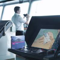
ECDIS: The Quiet Revolution in Maritime Navigation
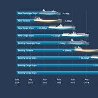
Driven by the SOLAS-mandated transition to ECDIS, the adoption of digital navigation is the most visible sign of how navigational practices are being transformed. Additional tools are also playing an important role in supporting bridge teams and delivering accurate navigational information to the bridge. We are now halfway through the transition period under the timetable set out in the amendments to the SOLAS Convention adopted in 2009, requiring the mandatory carriage of ECDIS for ships engaged on international voyages.
UK, Singapore Partner for Navigation Training
The United Kingdom Hydrographic Office (UKHO) and the Maritime and Port Authority of Singapore (MPA) have announced a new bursary training scheme in Marine Cartography and Data Assessment. Organized jointly by the UKHO and MPA over a five-week period from April 18, 2016 at the MPA Academy in Singapore, the course will train attendees on compiling and maintaining navigational charts. Drawn from 10 nations, the course attendees will comprise employees of their national hydrographic offices, port authorities and/or related national agencies involved in the production and maintenance of navigational charts. The course will equip students with skills to create and maintain paper and digital charts utilizing computer-aided cartography applications.
UKHO Warns of Counterfeit ADMIRALTY Products

The United Kingdom Hydrographic Office (UKHO) has observed an increase in the number of counterfeit versions of ADMIRALTY charts and publications in circulation and is re-issuing a warning over the dangers they pose to the safety of vessels, crew and cargo. These counterfeit items have not been assessed by UKHO experts, who cross check and quality assure ADMIRALTY Maritime Products & Services to ensure mariners receive up-to-date and accurate information. Information contained within counterfeit products has also not been issued officially by or on the authority of a Government…
Reduction in High Risk Area for Piracy Now in Force
As of 1 December 2015, the reduction to the High Risk Area (HRA) as defined in Best Management Practices 4, has taken effect. Further information may be found in our earlier web alert, published on 9 October 2015 and available. In response to the reduction in the HRA, the United Kingdom Hydrographic Office has published a revised version of Maritime Security Chart Q6099 which incorporates the changes. The club considers that the risk of piracy remains and recommends that members continue to exercise vigilance when trading to and through affected regions. On 1st December 2015, the limits of the HRA within the United Kingdom Maritime Trade Operation (UKMTO) Voluntary Reporting Area (VRA), shown on Maritime Security Chart Q6099, will be amended.
Majority of International Fleet Now Fitted With ECDIS
Large cargo ship fleet well prepared for July 2016 ECDIS regulations and ECDIS adoption accelerates among global tanker fleet. Over half of ships trading internationally are living with ECDIS, according to the latest figures published by the United Kingdom Hydrographic Office (UKHO). Of an estimated 41,500 internationally trading ships around the world, 24,300 or 58% are now using an ENC (Electronic Navigational Chart) service on ECDIS as a result of the SOLAS-mandated carriage of ECDIS, which is being introduced on a rolling timetable for different ship types and sizes. Moreover, when those that do not trade internationally are included, 45% of all ships that are subject to the SOLAS regulations are ECDIS ready.
UKHO Plans Hundreds of Port Approach Guides
The United Kingdom Hydrographic Office (UKHO) announced it continues to expand its Port Approach Guide portfolio, with coverage in Asia set to increase through the inclusion of ports in China. The UKHO's Port Approach Guides are port-scale charts that contain a range of planning and support information for some of the world's busiest ports. By providing bridge crews this information in one place, each guide can help simplify a number of passage planning tasks; making port entry and exit quicker and easier.
World ENC Charts Now in Nuno Navigator
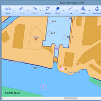
CherSoft’s professional navigation software Nuno Navigator now has access to a full portfolio of ENC charts from PRIMAR. ENC charts have traditionally been limited to ECDIS systems. Now, Nuno Navigator is bringing professional quality charts to smaller workboats, back offices, pilots, rig movement specialists and wherever a more complex and expensive ECDIS is not required. According to its developers, Nuno Navigator is particularly attractive to professionals needing a portable navigation system, who can travel with ENC charts on a rugged laptop.
54% of Tankers Comply with ECDIS Mandate

SOLAS regulations on the mandatory carriage of Electronic Chart Display and Information System (ECDIS) for all tankers of 3,000 gross metric tons or more come into force July 1, 2015. Of the more than 8,750 tankers in the global fleet that are required to comply with these regulations by their first survey following this date, 54 percent are now using ENCs (Electronic Nautical Charts) on ECDIS, according to United Kingdom Hydrographic Office (UKHO). Progress has been made in recent months…
UKHO ‘Living with ECDIS’ Seminars at Nor-Shipping

The United Kingdom Hydrographic Office (UKHO) has announced the details of its free-to-attend ECDIS Seminars at Nor-Shipping, which have been updated to include the implications for shipowners and operators of the updated IHO ENC (Electronic Nautical Charts) Standards. The UKHO’s ‘Living with ECDIS’ Seminars will take place on Wednesday, June 3 and Thursday, June 4 at Nor-Shipping and will be presented by Captain Paul Hailwood, a renowned expert on ECDIS and integrated bridge operations, and Tom Mellor.
UKHO Launches New H-Note App
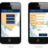
The United Kingdom Hydrographic Office (UKHO) has unveiled a new digital application that enables mariners to submit hydrographic data directly to the UKHO using their mobile device. The ADMIRALTY H-Note App is a free digital version of the UKHO’s Hydrographic Note and will allow important navigational information to be recorded and shared with the UKHO faster and more easily than ever before. The Hydrographic Note, often referred to as H-Note, is a vital source of new hydrographic data.
Majority of Global Tanker Fleet Yet to Adopt ECDIS
The majority of ships in the global tanker fleet have yet to adopt ECDIS, according to data published for the first time by the United Kingdom Hydrographic Office (UKHO). The SOLAS regulations on the mandatory carriage of ECDIS will come into force from July 1, 2015 for all tankers over 3,000 gross metric tons, apart from permitted exemptions. Over 8,500 tankers will be required to comply with these rules and, with less than 10 months to go, the UKHO can reveal that 58% of these ships do not yet use an ENC service.
Live Testing of New AVANTI Port Information Software

Live testing of ‘Avanti’, a new on-line web based application that provides validated nautical information for port users is due to commence at a number of European ports. Following successful prototype testing at Port of Rotterdam, the ports of Göthenburg, Marseille and Luela will commence live testing in spring 2014. Avanti has been developed by Envitia for the United Kingdom Hydrographic Office (UKHO) in collaboration with the International Harbour Masters’ Association (IHMA) and promises to make a major contribution to the rapidly expanding field of e-Navigation.
UKHO Publishes Guide to ECDIS Implementation
Next free ECDIS seminar in Hong Kong on Tuesday, February 25. The United Kingdom Hydrographic Office (UKHO) has published a new Nautical Publication to support the transition to ECDIS. The 'Admiralty Guide to ECDIS Implementation, Policy and Procedures (NP232)' has been designed to allow informed decision-making by any individual or organisation responsible for the introduction of ECDIS aboard ship. It is also intended to provide an onboard reference to support company procedures developed for the operation of ECDIS…
UKHO Launches New Routing Charts
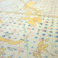
The United Kingdom Hydrographic Office is launching a new large-scale routing chart covering the busy shipping waters of Vietnam, Indonesia and the Malacca Strait. Routing Chart 5141 is the latest addition to the UKHO's routing chart series and will be published on February 27, 2014. As well as covering a very busy shipping area, Routing Chart 5141 has been compiled in a larger scale than the UKHO's existing routing charts and features more detailed and up-to-date meteorological and currents information.


