

Baltimore Bridge Collapse Highlights Need to Protect Critical Foundations
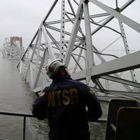
The collapse of Baltimore's Key Bridge has highlighted what engineers say is an urgent need to better protect the piers holding up spans over shipping channels as the size of cargo ships has grown in recent decades.Federal authorities continue an investigation into why a massive cargo ship lost power and crashed into a pier of the Francis Scott Key Bridge early Tuesday, bringing down the structure and killing six workers who had been filling potholes atop it.The Maryland Transportation Authority did not respond to questions about what…
Lyman-Morse Builds Workboat for the University of New Hampshire
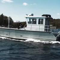
Thomaston, Maine based Lyman-Morse Boatbuilding announced it has built and delivered a new workboat for the University of New Hampshire.The new 33-foot-long aluminum landing craft was commissioned by the university's School of Marine Science and Ocean Engineering for work in its aquaculture research program in the Gulf of Maine.Operators can land the boat on rocky beaches without damaging the hull, while the wide-open bow functions as a stable and uncluttered work, cargo, or passenger space.
Discovery: Historic Shipwreck Found in Lake Huron
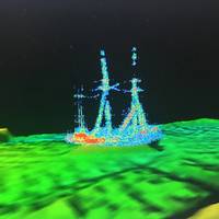
Researchers from NOAA, the state of Michigan, and Ocean Exploration Trust discovered an intact shipwreck resting hundreds of feet below the surface of Lake Huron. Located within NOAA's Thunder Bay National Marine Sanctuary, the shipwreck has been identified as the sailing ship Ironton. Well preserved by the cold freshwater of the Great Lakes for over a century, the 191-ft. Ironton rests upright with its three masts still standing."Using this cutting-edge technology, we have not only located a pristine shipwreck lost for over a century…
URI Unveils Name of New Research Vessel
The National Science Foundation’s new Regional Class Research Vessel that will soon call the University of Rhode Island’s Narragansett Bay Campus home has a name: Narragansett Dawn.Graduate School of Oceanography Dean Paula S. Bontempi announced the name of the new $125 million vessel after a nationwide competition and approval from the NSF.“Narragansett Dawn acknowledges the Indigenous peoples’ histories, ancestors, and perseverance in our communities today,” said URI President David M. Dooley.
VIDEO: Up Close and Personal with Ocean Explorer Robert Ballard
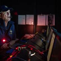
Ocean explorer and scientist Dr. Robert D. Ballard opens up on his personal life and his world-famous ocean discoveries like never before in his new book, “Into the Deep.” Best known as ‘the man who found the Titanic,’ Marine Technology Reporter had the opportunity to interview Ballard on the contents of the book, a book released yesterday with a follow-up National Geographic television special scheduled for June 14, 2021, taking a deep dive into his dyslexia, the importance of his family throughout his career…
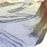
New Depth Map Over the Arctic Ocean
Details of a new depth map of the Arctic Ocean have been published in the nature journal Scientific Data. The new portrayal of the Arctic Ocean floor is in the form of a digital gridded database and comprises Version 4.0 of the International Bathymetric Chart of the Arctic Ocean (IBCAO).The gridded compilation has been completed under the auspices of the Regional Center for the Arctic and North Pacific Ocean of The Nippon Foundation-GEBCO Seabed 2030 Project. This Regional Center…
Fast-moving Waterfalls in the Deep Sea
New research led by the National Oceanography Center (NOC) has discovered how fast-moving waterfalls under the sea control the shape and behavior of submarine channels. These underwater channels are the offshore equivalents of rivers, but can be much larger. Submarine channels can extend for tens to thousands of kilometers offshore, providing an important conduit for the transfer of sediment, nutrients and pollutants, such as microplastics, to the deep-sea. Avalanches of sediment…
Shell Ocean Discovery XPRIZE Winner Annouced
The GEBCO NF- Alumni Team was announced as the $4 million grand prize winner of the Shell Ocean Discovery XPRIZE, a three-year global competition that challenged teams to advance deep sea technologies for autonomous and unmanned, fast and high-resolution ocean exploration. The team's winning concept includes the use of a unique unmanned surface vessel (USV) / autonomous underwater vessel (AUV) and associated combination of communications hardware and software to process and transmit data remotely.
Digital Feature Extraction with PropCad Premium 2018
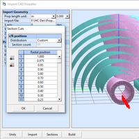
A new utility automates feature extraction from 3D CAD data.Marine propellers can last a long time – it is not uncommon to find a vessel running on its original set of propellers. Sometimes, these propellers even outlive the companies that produced them. For example, some large volume propeller manufacturers have permanently closed their doors and patterns, molds, and design data have been scattered to unknown corners of the globe. It’s fair to say that while the propeller manufacturing industry has seen growth…
All Operators Should Follow These Lubrication Steps

Maintaining mission-critical winches, windlasses and cranes: the four must-have lubrication steps that all operators need to keep gears going. In the marine industry, winches, windlasses and cranes are the work horses of deck and harbor operations. They can be used to set anchors, position floating drill rigs, raise and lower sensitive scientific equipment, tow a ship, load/unload heavy cargo or even land fish. They are as vital to the mission of a vessel or a port as the main engine is to a ship.
Overcoming the Propeller Supply Bottleneck
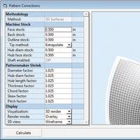
Hydrocomp’s ProCad facilitates in-house Process Control of Propeller Design and Manufacture. Maritime Tactical Systems Inc. (MARTAC) is a Florida-based company building next-generation unmanned vessels for military applications. In preparation for the “Rim of the Pacific” (RIMPAC) military exercises in Pearl Harbor this last July, MARTAC needed a new propeller design for their MANTAS series high-speed vessels. Unfortunately, their current supplier was not meeting delivery schedules for the high-quality surface-piercing propellers that they need…
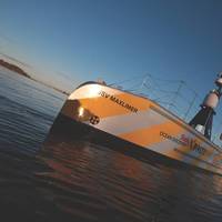
New Research Vessel for University of New Hampshire
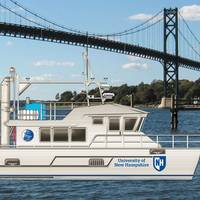
All American Marine, Inc. (AAM) has entered into a contract with the University of New Hampshire (UNH) for the design and construction of a new aluminum catamaran research vessel. AAM will build the 48’ x 17’ catamaran custom devised by Teknicraft Design, Ltd. of Auckland, New Zealand. The new vessel, funded through a grant from the National Oceanic and Atmospheric Administration (NOAA) will serve the Joint Hydrographic Center (JHC) at UNH. It will join UNH’s existing fleet and will complement capabilities by offering a highly complex multi-mission platform.
AAM, UNH in Vessel Design, Construction Pact
All American Marine, Inc.(AAM) together with the University of New Hampshire (UNH) are pleased to announce a contract for the design and construction of a new aluminum catamaran research vessel. All American Marine will build the 48’ x 17’ catamaran custom devised by Teknicraft Design, Ltd. of Auckland, New Zealand. The new vessel, funded through a grant from the National Oceanic and Atmospheric Administration (NOAA) will serve the Joint Hydrographic Center (JHC) at UNH. It will be joining the University’s existing fleet and will complement capabilities by offering a highly complex multi-mission platform. The aluminum hull will feature the Teknicraft Design signature hull shape with symmetrical bow, asymmetrical tunnel, and integrated wave piercer.
New Lineup for NOAA Hydrographic Services Panel
NOAA administrator Kathryn Sullivan, Ph.D., has appointed six members to the Hydrographic Services Review Panel, a federal advisory committee that gives NOAA independent advice for improving a range of services and products that support navigation and coastal resilience. Capt. “Providing coastal communities, boaters, and the commercial maritime industry with timely, reliable, accurate, and authoritative information is essential as we strive to keep commerce flowing through our nation’s ports,” Sullivan said. Rear Admiral Ken Barbor (ret.), U.S. Lawson W. Capt. Gary A. Scott R.
The Landing School Names Schuhmann President

The Landing School’s Board of Trustees is pleased to announce that it has named the 4th President of the Landing School. Richard J. Schuhmann, Ph.D., a former student at The Landing School and currently a Senior Lecturer and Program Manager at MIT, will begin as The Landing School’s next President on September 1, 2014. After an exhaustive search, Dr. Schuhmann was appointed on the unanimous recommendation of the Board of Trustees. He will succeed Bob DeColfmacker, who intends to retire while continuing to advise the school on strategy and major Projects. Dr.
ARGUS: Enviable Technology, Unlimited Potential
System is designed to universally interface with a vessel’s existing navigation equipment and autonomously deliver water depths seen by the vessel to a central server. Almost four years and 100 million soundings later, the concept is a reality. Almost two years after we first reported (December 2011 edition of MarineNews) on an innovative, depth sounding recorder device that made wide swaths of data available to perhaps anyone who wants it, the concept envisioned by ARGUS has developed into a viable tool that could change the way that government agencies schedule surveys and dredging. Today, about 40 boats have voluntarily placed on board their vessels the ARGUS (Autonomous Remote Global Underwater Surveillance) system transmitters.
NOAA's 'Ferdinand R. Hassler' Begins Survey Project
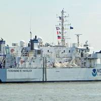
NOAA’s newest survey ship, the 'Ferdinand R. Hassler will operate mainly along the Atlantic and Gulf coasts, Caribbean Sea and Great Lakes, acquiring data to update NOAA’s nautical charts. Her mission, however, is not limited to collecting bathymetry, explains retired NOAA Capt. Andy Armstrong, co-director of the Joint Hydrographic Center/Center for Coastal and Ocean Mapping at the University of New Hampshire. Local government officials have provided a warm welcome to Hassler’s crew. Noting “the enthusiastic welcome from the townspeople and local businesses,” Hassler commanding officer Lt.
Transas SimUC 2013 to Address e-Navigation Challenges
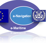
E-Navigation has been a hot topic in the maritime industry for some time, and it is likely that it will continue to be into the future. But for many in the industry, the subject remains an abstraction that everybody is talking about but few can properly explain. That is why the Future Challenges in e-Navigation session is one of the highlights of the Transas Simulation User Conference 2013 with its theme, Future Trends and New Challenges in Maritime Simulation. The session will…
HydroComp Adds Adam Kaplan as Project Engineer
HydroComp, Inc. added of Adam Kaplan to the staff in Durham, New Hampshire USA as Project Engineer. Adam will be the lead for development of new versions of PropExpert and PropCad software. He is also on the front-line of customer support to HydroComp’s worldwide users. Mr. Kaplan is not a new face to HydroComp; he started as engineering intern at HydroComp during his mechanical engineering studies at the University of New Hampshire College of Engineering and Physical Sciences where he earned both his B.S. and M.S. in Mechanical Engineering.
Polar Expedition Vessel the Sunken 'S.S. Terra Nova' Discovered
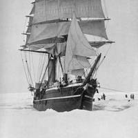
Schmidt Ocean Institute’s flagship 'R/V Falkor' locates the wreck of historic exploration ship off the coast of Greenland. During routine functional performance testing of the mutibeam mapping echosounders on the Schmidt Ocean Institute’s flagship R/V Falkor, the team aboard — including researchers from the University of New Hampshire, Ifremer, and Woods Hole Oceanographic Institution — discovered the S.S. Terra Nova, a whaler, sealer and polar exploration ship that sunk off the southern coast of Greenland in September, 1943, after being damaged by ice.
Marine Renewable Energy Conference Slated for October
The fourth annual Marine Renewable Energy Technical Conference will be held October 30-31, 2012, at the Crowne Plaza Hotel and Conference Center in Providence/Warwick, Rhode Island. The conference Technical Committee is now accepting extended abstracts for presentation at the Conference on topics related to tidal energy, wave energy, offshore wind, ocean currents, ocean thermal energy, and other ways to extract energy from oceans or rivers. Also of interest are engineering and environmental studies which further the sustainable development of marine renewable energy. The accepted abstracts will be made available on the New England MREC web site (www.mrec.umassd.edu) and on flash drives given to each attendee.
BSEE, NOAA Enhance Response Mapping
BSEE and NOAA to complete Arctic oil spill response mapping tool. The Bureau of Safety and Environmental Enforcement (BSEE) and the National Oceanic and Atmospheric Administration (NOAA) announced today they are partnering to enhance the Environmental Response Management Application (ERMA®) for the Arctic region by summer 2012. ERMA® is the same interactive online mapping tool used by federal responders during the Deepwater Horizon oil spill. This effort will help address numerous…
Arctic Surveys Yielding Data and Savings

U.S.-Canada Arctic Ocean survey partnership saved costs, increased data; 2011 mission concludes joint seafloor survey operations. A recent mission marked the completion of a five-year collaboration between the United States and Canada to survey the Arctic Ocean. The bilateral project collected scientific data to delineate the continental shelf beyond 200 nautical miles from the coastline, also known as the extended continental shelf (ECS). The U.S. has an inherent interest in knowing…


