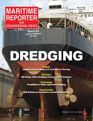
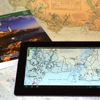
Geo Shipyard Delivers Catamaran Survey Vessel
Geo Shipyard, Inc. has built and delivered a new Survey Catamaran Vessel, Blake, for David Evans and Associates Inc.’s Marine Services Division in Gulfport, Mississippi. The newbuild, delivered in October, features wave-piercing bows, Tier 3 Cat diesels, twin 55-kW generators, a full suite of survey instrumentation, an A frame for towing astern, a DTI survey winch and a stainless steel hydraulically operated survey strut with a moon pool and hydraulically operated door through the wing deck to lower the strut for side scanning. There’s also a bow crane for side scanning in shallow water.
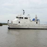
19th Century Shipwreck Found off Golden Gate Bridge
NOAA announced it has found the underwater wreck of the passenger steamer City of Chester, which sank in 1888 in a collision in dense fog near where the Golden Gate Bridge stands today. The announcement was made during a press event at Gulf of Farallones National Marine Sanctuary’s San Francisco headquarters at Crissy Field. NOAA’s predecessor agency first located ship in 1890, two years after it sank. The story of City of Chester will be shared with the public in a future waterfront exhibit NOAA will place at the sanctuary office at Crissy Field. The office is the former U.S.
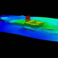
Coast Survey to Resove Magenta Line Issues
The Office of Coast Survey has announced that future editions of nautical charts of the Intracoastal Waterway will be updated to include an improved "magenta line" that has historically aided navigation down the East Coast and around the Gulf Coast. Additionally, Coast Survey will change the magenta line's function, from the perceived "recommended route" established more than a hundred years ago, to an advisory directional guide that helps prevent boaters from going astray in the maze of channels that comprise the route.
NOAA Updates Cobscook Bay Area Chart
Northern Maine vessels will be able to navigate more safely around the dangerous Cobscook Bay thanks to an updated version of the area's nautical chart issued by NOAA. The latest chart includes a new detailed illustration-called a "chart inset"-of the waters around Falls Island, providing safer passage for mariners who transit those waters. While NOAA cartographers had updated Chart 13394 (Grand Manan Channel) over the past several years, using depth measurements and obstruction locations acquired during a major hydrographic survey in 2010, a new inset was needed specifically for Falls Island. "Larger, more detailed scale coverage helps mitigate the dangers to navigation in these areas," explained Cmdr. Shep Smith, chief of NOAA Office of Coast Survey's Marine Chart Division.
New Navigational Product Trio from NOAA
NOAA highlight new US Chart 1, new chart of California waters with IMO TSS shown, and a beta mobile chart app for boaters. New U.S. For the 65 years since the U.S. Coast and Geodetic Survey issued the first edition of U.S. Chart No.1 in 1948, mariners have had a standard guide for understanding the symbols, abbreviations and terms used on paper nautical charts. In a major step forward, a new edition of that guide also describes the symbols specified by the International Hydrographic…
US Chart No. 1 Goes Electronic
U.S. Coast and Geodetic Survey Chart No.1 has described the symbols used on paper nautical charts for 65 years. Mariners have had a standard guide for understanding the symbols, abbreviations and terms used on paper nautical charts since 1948. In a major step forward, a new edition of that guide also describes the symbols specified by the International Hydrographic Organization for the display of electronic navigational charts (ENC) on Electronic Chart Display and Information Systems (ECDIS). Several maritime nations produce their own versions of Chart 1. The U.S. Chart No.
NOAA & US Power Squadrons Sign Agreement
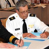
NOAA’s Office of Coast Survey & US Power Squadrons sign a Memorandum of Agreement to improve cooperative charting program. Rear Adm. Gerd Glang, director of NOAA’s Office of Coast Survey, recently sat down with John Alter, chief commander of the U.S. Power Squadrons (USPS) to sign up to a collaboration that began fifty years ago. The USPS is a nonprofit organization dedicated to safe boating through instruction in seamanship, navigation, and related subjects. With nearly 40,000 members in more than 400 squadrons across the U.S.
NOAA and U.S. Power Squadrons Renew Program
This week, NOAA and the U.S. Power Squadrons, a non-profit organization dedicated to safe boating, will renew a 50-year commitment to a cooperative charting program that helps to update the nation's thousands of navigational charts. Under the voluntary program, formalized by a Memorandum of Agreement, members of the U.S. Power Squadrons scan water and land areas, looking for changing conditions that may not be reflected on NOAA nautical charts. Power Squadrons members submit their reports online, and NOAA cartographers review and incorporate changes to their navigation products. "The partnership between Coast Survey and the Power Squadrons is a long and successful one, speaking to our shared vision of safety on U.S.
NOAA Team Assesses Debris Impacts in Gulf Region
view of side scan sonar image of sunken ship in Pascagoula, Miss. NOAA’s Office of Response and Restoration and Office of Coast Survey, working with the U.S. Coast Guard and other federal and state agencies, are assisting with Gulf of Mexico recovery efforts by performing hydrographic surveys and risk assessments of underwater debris left in the wake of Hurricane Katrina. The mapping aspect of the project will aid in the risk assessment and prioritization of the removal of debris to restore safe navigation and re-establish commercial fishing in the regions. The survey work will include sounding measurements to determine the depth of the debris…
NOAA Launches New Marine Science Portal
View of the USS Monitor wreck, which sank on Dec. 31, 1862, and now teams with marine life. NOAA and Immersion Presents launched oceanslive.org, a marine science portal that offers live video and special content to educate people of all ages about the ocean, including national marine sanctuaries. Immersion Presents is an after-school science education program founded by ocean explorer Robert Ballard. "NOAA is excited to offer this dynamic Internet-based resource, which will allow students, educators and the public to share in the thrill of discovery while learning more about the natural and cultural treasures of our national marine sanctuaries and the underwater world," said NOAA National Marine Sanctuary program director Daniel J. Basta.
NOAA Ship Decommissioned
U.S. decommissioned today in a ceremony at its home port in Norfolk, Va. waterways. manages the NOAA fleet of ships and aircraft. efficiently. charts. survey platform in the world. maritime commerce. terabytes - one terabyte equaling 1,000 gigabytes. mosaics as well as imagery of historical wrecks like the USS Monitor. oceanography, fisheries research and homeland security surveys. security and nautical charting and returned in November. marked an end to its 39 years of service. and all waters in between. the nation. finding the wreckage of John F. Kennedy's aircraft in 1999. 990 off the coast of Rhode Island. Cmdr. two years. Air 990 recovery efforts. tragedies involving aircraft lost at sea. who served in the U.S. Coast and Geodetic Survey. and the U.S. Naval Academy.