

Earthquake Offshore California Knocks Out Power for Thousands
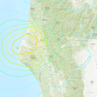
A strong 6.4-magnitude earthquake struck off the coast of northern California on Tuesday, the U.S. Geological Survey said, leaving thousands without power.The earthquake, which struck at 2:34 a.m. (1034 GMT), was about 10 miles (16.1 km) deep, USGS said, and struck about 7.4 (12 km) west-southwest of Ferndale, California, a Humboldt County town about a four-hour drive north of San Francisco.Local media and others on social media reported there were numerous gas leaks, powerlines down, and at least one structure fire in Ferndale.
MOSI Anti-Fouling Coatings for Barnacles and Zebra Mussels

Marine organisms such as barnacles and zebra mussels have been a long-standing nuisance to ship hulls, causing exterior damage, increased power and fuel consumption and environmental concerns. While anti-fouling coatings help to prevent biofouling, a new research study suggests that an innovative approach to marine coatings may solve the problem of barnacle and zebra mussel fouling, an approach stems from the MOSI (Marine Organism Sensory Interference) concept. MOSI uses a unique coating tech to interfere with the sensory ability of juvenile barnacles…
Update: Alaska, Canada Tsunami Alerts Lifted
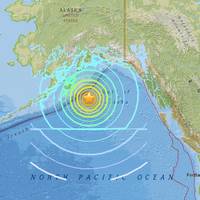
Alaska and parts of western Canada braced for a possible tsunami on Tuesday after a magnitude-7.9 earthquake struck the Gulf of Alaska, sparking evacuations in coastal Alaska and a tsunami warning for California that was later lifted. In Alaska, people packed into high schools and other evacuation centers after the quake hit shortly after midnight local time (0900 GMT). Officials had warned residents as far south as San Francisco to be ready to evacuate coastal areas but by 5:15 a.m. PST (1315 GMT) the U.S.
AIS, AtoN, MTS – and you
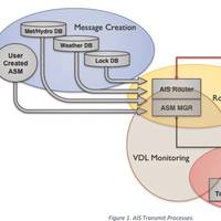
USACE and USCG collaborate to make inland waterways safer. The United States Army Corps of Engineers (USACE), supported by Alion Science and Technology (Alion), has put forth considerable effort during the last two years to further extend the capabilities of the existing Automatic Identification System (AIS) network to improve the safety and efficiency of navigation along the inland rivers. The USACE works with the United States Coast Guard (USCG) and other agencies and stakeholders to operate and maintain the nation’s Marine Transportation System (MTS).
Earthquake Measuring 5.0 Rattles Tokyo, Eastern Japan
An earthquake with a magnitude of 5.0 struck eastern Japan on Sunday and shook buildings in Tokyo, officials and witnesses said, but there was no danger of a tsunami and no immediate report of injuries or major damage. The US Geological Survey (USGS) put the epicentre of the quake 44 km (27 miles) northeast of Tokyo at a depth of about 44 km. There were no were immediate reports of damage. Broadcaster NHK reported that the Tokai No. 2 nuclear power station, which has been shut since 2011, was checked for damage after the quake but none was found. Earthquakes are common in Japan, one of the world's most seismically active areas, which accounts for a fifth of the world's earthquakes of magnitude 6 or larger.
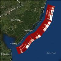
Excellence in Partnering Award for "Atlantic Canyons" Team
The National Oceanographic Partnership Program (NOPP) will present the 2015 Excellence in Partnering Award to 17 organizations involved in the Atlantic Canyons study during Ocean Sciences 2016 in New Orleans. The ceremony will take place on Tuesday, February 23, from 1:00 - 2:30 p.m. (CST) at the Ernest N. Morial Convention Center, Room 223. This multi-year effort leveraged the resources of the Bureau of Ocean Energy Management (BOEM), U.S. Geological Survey (USGS), NOAA Office of Ocean Exploration and Research, 12 universities and research institutions, and two companies, to explore Baltimore and Norfolk Canyons about 60 miles offshore of Maryland and Virginia.
SubM Debut Now Set for February 2016

The perennial “Year of Subchapter M” has been kicked forward again, this time to February 2016. That means that the clock is now ticking loudly for those towing operations that have yet to climb onboard the safety train. Quality operators see standardized safety practices as a way of leveling the playing field, integral to maintaining the health and profitability of their fleets, and key to winning business from quality customers. Subchapter M will be a phased-in over a period of years. It’s not as much time as you think.
Massive Explosions at Port of Tianjin Kill 44
A series of huge explosions shook the warehouse at Tianjin Port International Logistics Center in the northern Chinese city of Tianjin late Wednesday, killing at least 44 people and injuring hundreds more, according to officials and state media. The People's Daily newspaper said at least 520 people were injured, more than 60 of them seriously. As of Thursday morning, an unknown number of people remained unaccounted for in the wreckage. The initial explosion erupted at a warehouse for a logistics company in an industrial area of the port city, according to Tianjin police. The company was identified as Tianjin Dongjiang Port Rui Hai International Logistics Co. Ltd. The second explosion was so powerful that I felt the entire 16-floor-building was shaking, says an eye witness.
Research Shows Iron's Long Ocean Journey
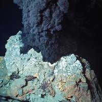
A new study led by scientists at the Woods Hole Oceanographic Institution (WHOI) points to the deep ocean as a major source of dissolved iron in the central Pacific Ocean. Researchers found that iron can travel long distances, highlighting the vital role ocean mixing plays in determining whether deep sources of iron reach the surface-dwelling life that need it to survive. Iron is readily soluble in low oxygen regions at hydrothermal vent sites and along continental margins, but it was believed iron remained in these localized spots and contributed minimally to the ocean's overall iron content.
An Open Arctic and its Impact on Oil Drilling
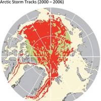
William Cho, Head of MatthewsDaniel Weather, a division of the Bureau Veritas Group, explains why improvements in drilling technologies and weather monitoring systems have made offshore shelf drilling operations in the Arctic Circle increasingly attractive to upstream oil and gas companies and their investors. Rising crude oil prices motivate not only technological innovators to explore cheaper alternative energy sources, such as solar panels and wind turbines, but also upstream oil and gas companies to explore new oil reserves which had not otherwise been economical.
Sensors Track Gulf of Mexico's Nitrate Pulse
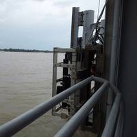
A new U.S. Geological Survey (USGS) report describes how advanced optical sensor technology is being used in the Mississippi River basin to accurately track the nitrate pulse to the Gulf of Mexico. Excessive springtime nitrate runoff from agricultural land and other sources in the Mississippi drainage flows into the Mississippi River and downstream to the Gulf of Mexico. This excess nitrate contributes to the Gulf of Mexico hypoxic zone, an area with low oxygen known commonly as the "dead zone." NOAA-supported researchers reported that the summer 2014 dead zone covered about 5…
Burger Boat Delivers R/V Arcticus
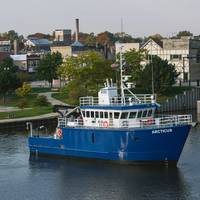
Burger Boat Company delivered the R/V Arcticus, a 78-foot research vessel for the United States Geological Survey (USGS), on Friday, October 17, 2014. The Arcticus replaces the 38-year-old R/V Grayling and brings the USGS Great Lakes Science Center (GLSC) large vessel fleet up-to-date. The Arcticus will be stationed at the USGS base in Cheboygan, Michigan and incorporates modern marine standards and state-of-the-art technology to more safely and effectively conduct fisheries research.
Pesticides a Concern for Aquatic Life in U.S. Rivers & Streams
Levels of pesticides continue to be a concern for aquatic life in many of the Nation’s rivers and streams in agricultural and urban areas, according to a new USGS study spanning two decades (1992-2011). Pesticide levels seldom exceeded human health benchmarks. Over half a billion pounds of pesticides are used annually in the U.S. to increase crop production and reduce insect-borne disease, but some of these pesticides are occurring at concentrations that pose a concern for aquatic life. The proportion of streams with one or more pesticides that exceeded an aquatic-life benchmark was similar between the two decades for streams and rivers draining agricultural and mixed-land use areas, but much greater during the 2002-2011 for streams draining urban areas.
East and South China Sea Disputes Need Creative Diplomacy
China and the United States appear headed for a damaging confrontation over the extent of China's territorial claims in the South and East China Seas. Now that China has become the world's largest importer of oil, and energy more generally, the country's need to develop more indigenous energy supplies has become urgent. Expecting China to put the South and East China Seas off limits to exploration and production until disputes over sovereignty can be resolved through some undefined legal or diplomatic process is unrealistic. Part of the problem is that western analysts and policymakers still fail to appreciate the strategic importance of these areas.
4.6 Magnitude Earthquake Hits Capital of Venezuela
A 4.6 magnitude earthquake shook the capital on Saturday and the Caribbean coast of Venezuela, without preliminary damage or casualties were reported. The epicenter was 25 kilometers northeast of the town of El Limon in the state of Aragua, and 67 miles west of Caracas, said the United States Geological Survey (USGS for its acronym in English). "So far we have not seen any injury to persons or wounded this product trembling," said the governor of Aragua, Tarek El Aissami, by a local television station. Local media said that so far had no reported damage. The quake was also felt in the state of Carabobo, Aragua neighbor and Civil Protection reported no affectations.
Large Dead Zone Found in Gulf of Mexico
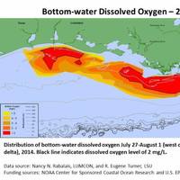
Mapped size confirms NOAA forecast for an average-sized hypoxia zone this year. NOAA- and EPA-supported scientists have mapped the Gulf of Mexico dead zone, an area with low oxygen water, measuring 5,052 square miles this summer--approximately the size of the state of Connecticut. The measurements were taken during the 30th annual hypoxia survey cruise from July 27 to August 2. This area falls within the predicted range of 4,633 to 5,708 square miles forecast by a suite of NOAA-sponsored models…
16 U.S. States at High Risk of Damaging Earthquakes -USGS
Sixteen states are at high risk of damaging earthquakes over the next 50 years and certain areas of the United States face a higher threat of temblors than previously thought, a federal geological survey agency said. The findings come from updated earthquake hazard maps that were released by the U.S. Geological Survey on Thursday. The maps are used to help define safe building codes, help emergency responders plan after a quake, and influence insurance rates, the report said. "The cost of inaction in planning for future earthquakes and other natural disasters can be very high, as demonstrated by several recent damaging events across the globe," Mark Petersen, chief of the USGS National Seismic Hazard Mapping Project, said in a statement.
6.8 Magnitude Earthquake in E. Japan Triggers Tsunami Alert
An earthquake of magnitude 6.8 occurred Friday about 165 kilometers east of the city of Iwaki on Honshu, the main island of Japan, prompting the authorities to issue an alert tsunami in the area. The U.S. Geological Survey (USGS for its acronym in English) said the quake occurred at 1922 GMT at a depth of 10 kilometers. (Reporting by Sonya Hepinstall. Published in Spanish by Bill Trott)
6.2 Earthquake Near Iwo Jima, Japan - USGS
The U.S. Geological Survey (USGS) said Sunday in Japan's volcanic archipelago 84 miles east-southeast of Iwo Jima (167 km) of the earthquake, a magnitude of 6.2. Japan Broadcasting Corporation (NHK) said there is no tsunami threat. The U.S. Geological Survey earlier reported that the quake a magnitude of 6.4. (Compiled on Chunhong; revision clouds)
Magnitude 8 earthquake Hits off Alaska's Aleutian Islands
A magnitude 8 earthquake Monday shook the Aleutian Islands of Alaska to the west, prompting authorities to issue a tsunami alert local, the United States Geological Survey and the Tsunami Warning Center said Pacific. The warning covering the coastal areas of the U.S. state of Alaska from Nikolski to Attu, the center said, adding that the authorities were assessing the level of risk to other coastal areas of the United States and Canada. The epicenter of the quake was about 23 kilometers of Little Sitkin Island, Alaska, at a depth of 114 kilometers, the USGS said (by its acronym in English). (Reporting by Eric Beech in Washington. Published in Spanish by Bill Trott)
USGS iCoast – Did the Coast Change?
Hurricane season starts again this June. Do you know what happens to our coasts after these extreme storms? The U.S. Geological Survey (USGS) has launched a new crowdsourcing application called “iCoast – Did the Coast Change?” to show you these coastal changes from extreme storms. iCoast allows citizen scientists to identify changes to the coast by comparing aerial photographs taken before and after storms. Crowdsourced data from iCoast will help USGS improve predictive models of coastal change and educate the public about the vulnerability of coastal communities to extreme storms.
Managing Ice Jams
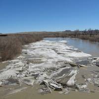
April showers may bring May flowers, but spring can also bring ice jams to the thawing rivers and streams across the northern United States. An ice jam or ice dam, is a buildup of broken ice in the river system. It can be a problem that causes the water to back up over the top of highway bridges, roads, or into cities. At times, they can cause flooding. Ice jams can be large–backing up water for miles, or small and only back up water in a small area locally. An ice jam can damage bridges with the amount of water pushing on the jam from behind…
Shale Oil Is it a Threat to Future Deepwater Development?
In general the floating production sector looks healthy and growth remains strong. But the sudden expansion of shale oil and tight oil production could disrupt the growth trajectory in the deepwater sector. The underlying drivers for deepwater development point toward continued sector growth. Spot and futures crude pricing is at levels supporting deepwater development. Oil demand keeps growing and there continues to be need for new future sources of oil. The threat of supply disruption from traditional sources remains, prompting oil companies to look at alternative sources. Activity in the deepwater sector is robust. More than 200 deepwater projects are in the planning stage that will likely require a floating production system for development.


