

Alfa Laval to Buy Weather Services Firm StormGeo

Swedish Alfa Laval has struck a deal to acquire weather intelligence and decision support services provider StormGeo.Alfa Lava, specializing in heat transfer, centrifugal separation, and fluid handling, said the acquisition would accelerate its digital services offering and to add an important tool to the decarbonizing toolbox offering. StormGeo provides weather-centric services to more than 2,200 customers globally in a variety of industries, including shipping, energy, and onshore industries such as healthcare…
LR to Acquire C-MAP Commercial from Navico

Lloyd's Register (LR) said it has reached a deal to acquire Navico Group’s C-MAP commercial marine business, a provider of commercial marine cartography and digital publications, shore-side and shipside voyage optimization, cloud-based fleet management and fleet analytics software. Financial terms were not disclosed. The acquisition, which includes C-MAP’s charts and publications, route planning and fleet management, weather services, professional services, and marine hydrographic services, will be integrated with into Lloyd's Register's i4 Insight performance platform.
Special Weather Bulletin for Gulf Region
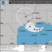
Invest 92-L, which may become Tropical Storm Barry by Thursday, is becoming better organized this morning as satellite imagery and surface weather observations indicate that a circulation seems to be developing over the northeastern Gulf of Mexico.In addition, it appears that the deeper thunderstorm activity is occurring offshore and it appears that Invest 92-L is located further south than what many of the model guidance members have indicated in their forecasts.
StormGeo Acquires Nautisk
Weather intelligence and decision support services provider StormGeo has entered into an agreement to acquire Nautisk, a global supplier of maritime charts and publications to the merchant marine from NHST Media Group. The combination allows StormGeo to integrate routing and weather services with its charts and publications solutions.According to Per-Olof Schroeder, CEO of StormGeo, “The acquisition of Nautisk is a natural complement to our existing solutions to the global shipping industry. In recent years, Nautisk has developed state-of-the-art software for use in planning and navigation, while maintaining one of the industry’s best run operations for delivering paper charts and publications to vessels worldwide.
Infoplaza and BMT ARGOSS Merge
Global weather services providers Infoplaza BV and BMT ARGOSS BV announced Thursday they will combine activities with immediate effect to build a stronger position in the Dutch weather market as well as the international offshore and marine industries.Joint operations will be headquartered at the Infoplaza offices in Houten. In the short term both companies will continue to operate under their own brands.In recent years BMT ARGOSS has established a significant share in the international offshore and marine industry, with a strong focus on producing high quality forecasts derived from knowledge and experience of high resolution modelling.
IMO DCS Regs: A Game-Changer in Shipping

Weather critical to fulfilling IMO DCS potential and boosting shipping’s sustainability says StormGeoStormGeo believes the upcoming IMO DCS (Data Collection System) regulation can be a game-changer for shipping – enabling a more environmentally and commercially sustainable age of operations. However, according to the global leader in weather forecasting and maritime decision support services, vessels must harness the potential of continual route optimization to realize maximum benefits.IMO DCS data collection on 1 January 2019.
El Faro Investigators Call for Better Weather Forecasting

New recommendations coming out of the investigation into the 2015 sinking of U.S. cargo ship El Faro call for efforts to improve the weather information available to mariners. All 33 crew on board died when the 790-foot El Faro sank close to the eye of Hurricane Joaquin near the Bahamas on October 1, 2015, two days after leaving Jacksonville, Fla. en route to Puerto Rico. Now, as part of its ongoing investigation into the incident, the National Transportation Safety Board (NTSB)…
RedPort XGate Now Includes PredictWind Weather Service
Newly available version of RedPort XGate satellite email and data services suite now includes PredictWind weather forecasting service, letting users select, download and view marine weather forecasts over satellite and cellular networks. RedPort Global announced the immediate availability of a new version of XGate, now including the PredictWind Offshore weather-forecasting app. XGate is an independent satellite data acceleration service letting people easily and affordably access accelerated email, web, weather data, social media and blogging wherever they go. PredictWind Offshore allows users to download and immediately view GRIB files, weather routes, GMDSS Text forecasts and Satellite Imagery.
Seapilot Class B AIS Available in North America
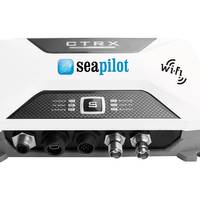
True Heading, a manufacturer of Automatic Identification System (AIS) solutions, GPS compasses and app navigation, announced its complete line of Graphene Class B AIS transponders have received type approval and are now shipping in the North American market. The Seapilot Class B AIS is offered in four different versions, the CTRX Graphene, WiFi-AIS CTRX Graphene, CTRX Graphene+ and WiFi-AIS CTRX Graphene+. Compact and easy to install, the Seapilot Class B transmitter sends vessel information including heading and speed…
Jeppesen Simplifies Routing, Chart Management
NauticalManager from Jeppesen allows mariners to easily plan, generate and document routes using an ECDIS and onboard PC. It also makes it simple to create the reports required by port state control and class auditors for checking a vessel’s ECDIS compliance. NauticalManager eases the bridge-side burden of ENC management by making it simple to order Official ENCs, review the chart portfolio and integrate temporary and preliminary Notices to Mariners. NauticalManager was developed…
Baron Releases New Weather Software
Weather services company Baron Services, Inc. announced the immediate availability of the Velocity Weather API, designed for use by marine industry manufacturers and software developers who want to integrate a weather stream into their final product, including smart phone and tablet apps, websites, MFDs and chart plotters. According to the developer, Velocity Weather API delivers powerful, reliable, location-based and meteorologically accurate weather and atmospheric data via the Internet.
Transas Data Service: Five Years on the Market
Transas marks the fifth anniversary of its Transas Admiralty Data Service (TADS) providing a comprehensive and official chart data service to the market. Transas, an ECDIS manufacturer, in conjunction with the United Kingdom Hydrographic Office (UKHO) launched Transas Admiralty Data Service (TADS) in 2008. TADS is based on 100% official ENC data from the UKHO converted in SENC format and optimized for use on Transas ECDIS. Since its launch, TADS has evolved into a complete set of data services required by mariners for voyage planning and navigation purposes, and today it’s far more than just official ENC data service. TADS now includes Admiralty digital publications, weather services and Admiralty Information Overlay with T&P Notices to Mariners.
S.A. Agulhas II
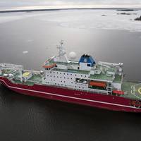
The Polar Research Vessel S.A. Agulhas II has been built by STX Finland for the South African Department of Environmental Affairs (DEA). The ship is a modern and sophisticated research vessel, commissioned to the DEA in May 2012, built to replace the S.A. Agulhas after 33 years of service. The ship will support the South African National Antarctic Expedition (SANAE IV) base on the Antarctic continent, a base which conducts research in the fields of physical sciences, earth sciences and life sciences.
STX Shipyard Delivers Polar Supply and Research Vessel
On Wednesday, April 4, 2012, the STX Finland Rauma Shipyard delivered a polar supply and research vessel to the South African government's Department of Environmental Affairs. Newbuilding 1369, S.A. Agulhas II is a multipurpose vessel which, among other tasks, operates as a supply, research and passenger vessel, as well as an icebreaker. Representatives from the client, the South African Government's Department of Environmental Affairs, as well as the Embassy of South-Africa in Finland, The South African Maritime Authority, classification society Det Norske Veritas and STX Finland and the press were there to witness the flag-changing ceremony. The ice-strengthened vessel is approximately 134 metres long and has accommodation for a crew of 45 and some 100 researchers or passengers.
Barge Traffic Still Slow On Mississippi
Barge traffic on U.S. Midwest rivers continued slow as low water levels on the upper and lower Mississippi River and ice buildup on the Illinois River kept navigation treacherous, Reuters reported on Wednesday. "At the Memphis gauge, the water level is about three feet below the desired level," said Lt. Brian Meier, U.S. Coast Guard spokesman, Memphis office. "The forecast is for water levels to stay pretty steady for next couple days," he said. Low water levels and a barge grounding about 30 miles south of Memphis this week caused river officials to issue a travel advisory from Cairo, Illinois, to Vicksburg, Mississippi. Southbound tows were limited to 30 barges and northbound tows limited to 36 barges with a 10-foot draft or less. In the St.
Barges Start Moving South of Peoria
Barges were moving through the LaGrange Lock south of Peoria on the Illinois River on Tuesday after workers broke through a wall of ice near the lock late on Saturday, U.S. Army Corps of Engineers spokeswoman said. "LaGrange is open but traffic is moving slowly. Ice is still very intense but we're still locking boats with a width restriction of 95 feet," said U.S. Army Corps of Engineers spokeswoman Justine Barati. "There was up to eight barges waiting but we're down to three southbound tows and one northbound waiting to get through the lock," Barati said. The U.S. Coast Guard closed a 60-mile stretch of the Illinois River near the LaGrange lock between mile marker 119 near Havana, Illinois, southward to Valley City, Illinois, at mile marker 60, on Thursday night.
USCG Issues High Water Warnings
The U.S. Coast Guard issued a safety travel advisory for sections of the upper Mississippi and Missouri rivers due to rising water levels near St. Louis. The Coast Guard said barges traveling on the upper-Mississippi River near Alton, Illinois, to Cape Girardeau, Missouri, (mile markers 205.0 to 55.2) and on the Missouri River near St. Louis (mile markers 0.0 to 150.0) were advised to watch for sudden changes in river conditions over the next several days. Rain over the weekend in the upper Midwest caused water levels in the St. Louis area to rise and they were expected to keep moving up over the next several days. The National Weather Service along with the U.S. Army Corps of Engineers forecasted an increase in river levels from 5 to 10 feet over the next 24 to 48 hours.
As Mississippi Rises, Locks Close
River locks around St. Paul and Minneapolis, Minn. were expected to close on Tuesday due to rising water conditions, further delaying the latest tow arrival to St. Paul in the last 30 years. "We're looking at having to close the three Twin Cities locks. We've hit 1997 flood levels, and we may have to close locks 2, 3, 4, 5 and 5a on the Mississippi," said Dennis Erickson, chief of operations for the Army Corps of Engineers in St. Paul. The closings affect 120 miles of the upper Mississippi River from Minneapolis south to Winona, Minn. Based on current weather forecasts for the area, the Army Corps of Engineers anticipated closing the locks to all river traffic from April 10 through April 20. Water levels on the Mississippi have risen more than two feet in the Minneapolis-St.
Jeppesen Launches Marine Business Unit
Marine, its newest business venture. marine market with similar digital navigation and information solutions. trusted history,” said Tim Sukle, senior vice president, Jeppesen Marine. aviation and marine markets. solutions. aviation markets to marine markets. core aviation business,” said Mark Van Tine, Jeppesen president and COO. recreational boating market. and more. the coming years. navigation and other data to flow in real time to ships all over the world. aviation and soon-to-be maritime markets. weather services and aviation training systems. produce a full line of navigation solutions and global maritime data services. Russia. Boeing Commercial Airplanes.
High Water Forces Lock Closures
The U.S. Army Corps of Engineers will close additional locks on the upper Mississippi River north of St. Louis beginning on Monday (April 23) due to rising water levels, Army Corps officials said. Lock 22 near Hannibal, Mo., about 150 miles north of St. Louis, was scheduled to close on Monday afternoon and Lock 21 near Quincy, Ill., will close on Tuesday. The Army Corps had closed Lock 20 at Canton, Mo., over the weekend but was keeping Lock 19 near Keokuk, Ia., open for local traffic. So all locks from Canton north to Minnespolis, except Keokuk, were now closed to traffic due to high water. The latest lock closures are north of the confluence of the Illinois River, where barge traffic remains unaffected by the flood conditions on the upper Mississippi.
Low Water Hampers River Traffic
Already low water on the Mississippi River around St. Louis was expected by this weekend to approach levels too shallow for barge transportation, and a damaged lock slowed river traffic near Davenport, Iowa, river officials said Thursday. The St. Louis gauge for the Mississippi was at 3.0 feet on Wednesday and was forecast to hit 0.0 feet by Saturday. River traffic can continue operation through St. Louis until the gauge hits -3.5 feet and the river channel is 9 feet deep, the shallowest depth at which barge traffic can pass. "Any time it gets below five feet on the St. Louis gauge, everybody starts to monitor that. And when it gets below zero the river industry will start forming a low action water group and you'll see restrictions on tows and other things…
Mississippi River Traffic Stalled
Mississippi River barge traffic near Burlington, Iowa, remained backed up on Thursday after lock 18 in Gulfport, Illinois, reopened Wednesday afternoon after a day-long shutdown, river officials said. Lock 18 was closed Tuesday morning when a breakaway barge caused two loaded barges to sink near the lock and left six other barges adrift at the dam. "We've got two barges still floating in the dam and two sunk, with the salvage unit on the way to clear it out. But we've been up and running since noon yesterday," said Frank Robbins, lock master at Gulfport, which is about 60 miles south of Davenport, Iowa. But river traffic was still feeling the effects of the shutdown on Thursday morning, as 5 northbound barge tows and 9 southbound tows were backed up outside lock 18.


