CEACT Allows Operators to REACT

How updated electronic navigation practices improve safety and efficiency – and optimize cargo movement – on US inland waterways.
It was a cold winter night. Heavy gusts and snow did not allow safe navigation and forced the ships on the upper Mississippi to secure alongside the few remaining jetties. Safety is the key issue for all river transport companies but at the same time efficiency and timely delivery of valuable goods is of utmost importance. It was 1999 and an American navigation pioneer – Greg Dunkle – had realized the potential of electronic chart systems. Tailored to fulfill the needs of river pilots, CEACT was born and for the first time safety and efficiency could be optimized at the same time.
Founded in 1999, CEACT stands for Channel ECDIS, AIS & Course Trajectory and offers navigation software specifically designed for professional towboats and workboat operations within the confined waterways of the US inland river system. The first CEACT system was launched in 2001 after two years of intense development effort. Today, it is used by domestic barge companies and is additionally utilized internationally on inland river systems in Latin America and South East Asia. Notably, here in the United States, CEACT is today used by an oil major and Southern Towing on their vessels. SevenCs GmbH is a software house that develops software for the maritime navigation industry. Its key products include portable pilot units and CEACT.
Optimizing Operations = Safety & Efficiency
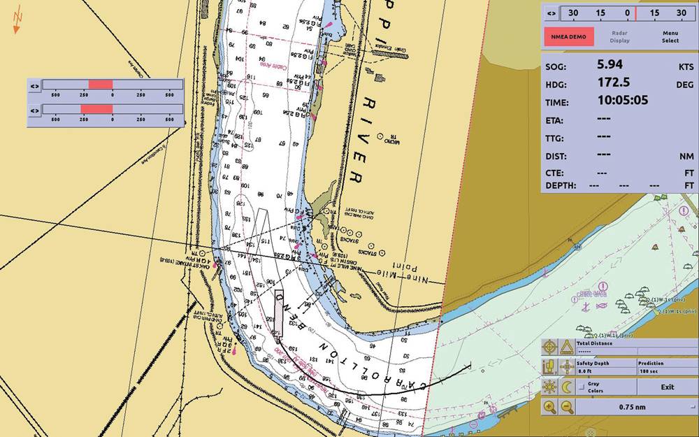
Real-time navigation and AIS target display provided full situational awareness and allowed to avoid dangerous situations before they occurred. But the main factor for more efficiency in the daily operation of CEACT was the innovative approach to consider the combined effects of vessel propulsion, rudder, wind and water current – all displayed in one easy to use “course trajectory” display. As an example, avoiding oversteer helps saving up to 10 percent of fuel consumption and allows for more efficient vessel operations in an increasingly competitive market.
But safety of navigation also depends on accurate charts. Together with the USACE, CEACT INC pushed the production of highly accurate inland vector charts in S-57 format. The US Western River chart package is automatically loaded and updated inside CEACT. Delivered in small package SENC format via the only certified value added reseller, CEACT still is the only inland ECDIS which relies on pre-tested official data and not on unsafe RSS feeds. One more reason why CEACT is THE safety tool which helps preventing accidents on the western rivers, but also in coastal waters covered by BSB or S-57 NOAA charts.
Greg and his team identified the requirement to ease chart operations and included a convenient download button within CEACT which allows weekly updating of all river charts plus the new USACE buoy overlay at a fingertip providing the smallest data volume on the market.
Today there are many navigation products in the market which are being used by marine pilots, yachtsmen and workboats. Some of these products are loaded with hundreds of options which make operation under extreme conditions difficult and may lead to errors. For CEACT and its users, ease of operation and high reliability with a proven downtime of only 8 hours per year (better than 99.9 percent availability!) are still an industry benchmark.
CEACT Updated
The latest CEACT version has just been released and still helps keeping ships and barges moving; regardless how bad conditions may be. The new version includes a new interface for enhanced readability in all ambient conditions, and more user friendliness in general. This helps the river pilot to safely navigate and focus on the most relevant data which helps prevent accidents. The advanced chart rendering allows faster loading and display of the respective chart which remarkably optimizes the application. Users will also benefit from the fully automatic CPA function which includes different types of calculation for rivers, channels and offshore. With extended support of BSB charts including head-up display CEACT becomes more powerful in remote areas not yet covered by ENCs.
Together with the well-established and widely shared Western River Chart package, weekly updates, and the USACE´s buoy overlays, CEACT continues to significantly increase the safety on board.
www.ceact.com
(As published in the March 2014 edition of Marine News - www.marinelink.com)