NOAA Satellites Aid in 263 Rescues in 2012

The same NOAA weather and climate satellites that accurately tracked Hurricane Sandy’s path in October also played a key role in rescuing 263 people in 111 emergencies in the United States and surrounding waters in 2012.
Since NOAA’s seven operational satellites circle the globe or sit above the United States, they also carry instruments to detect distress signals from emergency beacons carried by downed pilots, shipwrecked boaters and stranded hikers.
In addition to their role in weather prediction, these polar-orbiting and geostationary satellites are part of the international Search and Rescue Satellite-Aided Tracking System, called Cospas-Sarsat. This system uses a network of satellites to quickly pinpoint the location of the distress signals.
“NOAA satellites were instrumental in emergency situations,” said Chris O’Connors, program manager for NOAA SARSAT. “Our ability to pick up a distress signal, isolate the location within 100 yards, and initiate the appropriate rescue response definitely saves lives.”
Of the 263 people who were rescued last year, 182 were rescued from the water, 22 from aviation incidents and 59 situations on land, where they used Personal Locator Beacons (PLB). Other rescue highlights in 2012 include:
- Alaska had the most rescues with 45, followed by 38 in North Carolina and
- 25 in Florida.
- 14 people were rescued from the tall ship HMS Bounty which was caught in a torrent of waves more than 200 miles off the North Carolina coast.
- Three people were rescued after their sailboat rolled in heavy waves off the San Francisco coast.
- In the Gulf of Mexico, five people were pulled to safety when their fishing boat began taking on water.
- Seven were rescued 400 miles west of Honolulu after their fishing boat caught fire.
- A Boy Scout troop on a canoe trip in Yuma, Ariz., activated its PLB for its scout leader, who was having a medical emergency.
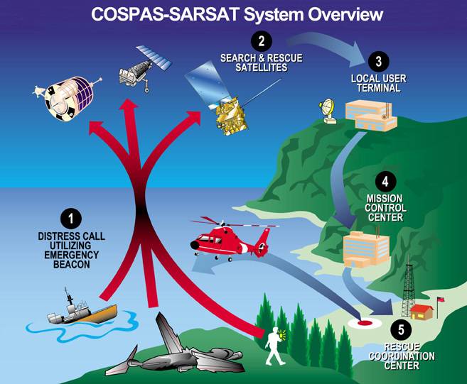
When a NOAA satellite finds the location of a distress signal, the information is relayed to the SARSAT Mission Control Center based at NOAA’s Satellite Operations Facility in Suitland, Md. From there, the information is quickly sent to a Rescue Coordination Center, operated either by the U.S. Air Force, for land rescues, or the U.S. Coast Guard, for rescues at sea.
SARSAT system overview.
Since 1982 when the program was started, Cospas-Sarsat has been credited with supporting more than 30,000 rescues worldwide, including 6,999 in the United States and its surrounding waters.
Owning a SARSAT device is only the first step to ensure one’s safety. It is imperative that the owner register their beacon with NOAA. This gives critical information to responders including the owner’s name, personal and family member contact information, and the type of vessel or aircraft. Registration is required by law and may be completed online.
In 2012, there were more than 37,000 new registrations, a record number for one year. NOAA’s registration database has more than 360,000 registered beacon owners.