Can Google Track Warships Better than DoD?

Google’s claim that its new satellite space will enable ship-tracking of warships is simply not true says expert
No way, says Guy Thomas, a man who’s in a position to know because he designed the satellite on which the information giant is renting space for its latest venture — a satellite that uses the same technology the Navy and the Coast Guard use.
“Anybody driving along the shore with a pair of binoculars can see that destroyer out there. That’s the only time those ships have AIS on,” said Thomas, the Coast Guard’s science and technology adviser for maritime domain awareness.
The controversy over AIS popped up after Michael Jones, chief technology advocate for Google Ventures, said in a May 17 speech to the U.S. Naval Institute’s annual Joint Warfighting Conference that his company was developing a system to track ships at sea globally — including naval vessels.
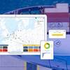
AIS is just one piece of the Collaboration in Space for International Global Maritime Awareness, an international collaboration to create a service that could be used by navies, coast guards, first responders, the U.S. Transportation Department and those who track illegal resource pillaging, like the National Oceanic and Atmospheric Administration. C-SIGMA, which is still in the planning phase, would combine information from four types of satellites to give ships a better awareness of who is around them.