

Satellite Images, Data Show Russian Ship 'Looting' Ukrainian Grain
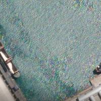
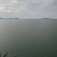
Late last month, a Russian-flagged cargo ship carrying corn pulled into the Turkish port of Izmir on the Aegean Sea. The SV Nikolay had loaded the grain at Port Kavkaz, in Russia, six days earlier on June 18, according to documentation provided by an employee of the Russian company that owns the ship.A Reuters analysis of satellite imagery, ship-tracking data and open-source photos and videos yields a different port of origin for the SV Nikolay. On June 18, Reuters’ analysis of a satellite image indicates…
Salvors Gear Up to Refloat Grounded Containership Ever Forward
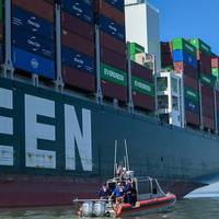
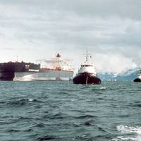
Salvors will attempt to refloat the Ever Forward on Tuesday following a week of dredging to free the grounded containership outside the Port of Baltimore.According to the port's executive director William Doyle, a team of five tugs, including two pushing on the ship's starboard side, two pulling from port side and one long pull from stern, will aim to dislodge the 1,095-foot ship, which went hard aground outside of the Craighill Channel near Gibson Island on March 13.During the refloat attempt…
Danos Wraps Coastal Restoration Work for Shell in Louisiana
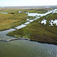
In late 2021, Danos completed four coastal restoration projects in south Louisiana on behalf of Shell Pipeline Company. The work will provide shoreline protection through a combination of customized 3D printed modules, nicknamed “Cajun Coral,” and advanced satellite image monitoring with partner Natrx, Inc. The project designs and installation procedures were tailored to local site conditions in order to enhance biodiversity and shoreline stability.“Louisiana’s coast is vital to our industry and our environment,” said Paul Danos, CEO of Danos.
Oil Workers Race to Protect Beaches from Spill Offshore Thailand
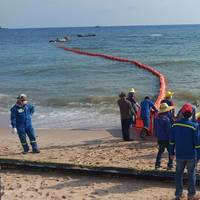
Hundreds of workers set up oil barriers along beach fronts in Thailand's eastern Rayong province on Friday as authorities raced to limit the environmental damage from gallons of oil that leaked from an underwater pipeline earlier this week.The leak from a pipeline owned by Star Petroleum Refining Public Company Limited (SPRC) started late on Tuesday and was brought under control a day later after spilling an estimated 50,000 litres (13,209 gallons) of oil into the ocean 20 kilometers…
Dredgers Spotted Off Cambodian Base Where China is Funding Work
Dredgers have been spotted off Cambodia’s Ream naval base, where China is funding construction work and deeper port facilities would be necessary for the docking of larger military ships, a U.S. think tank said on Friday.The United States, which has sought to push back against Beijing's extensive territorial claims and military expansion in the South China Sea, reiterated its "serious concerns" about China's construction and military presence at Ream."These developments threaten U.S.
Black Sea Oil Spill Much Larger than Initially Reported
An oil spill off Russia's Black Sea coast over the weekend spread over an area of nearly 80 square kilometers and was much larger than initially thought, scientists at Russia's Academy of Sciences (RAN) said on Wednesday citing satellite imaging.A leak occurred as the Greek-flagged Minerva Symphony tanker took on oil at the Yuzhno-Ozereyevka sea terminal near Novorossiysk in southern Russia, the Caspian Pipeline Consortium that owns the terminal said on Monday.The consortium, which transports oil from Kazakhstan, said on Monday the spill had spread over 200 square meters and involved 12 cubic meters of oil. It said the spill was quickly contained and posed no threat to people or wildlife.But on Wednesday…
'Oil Spot' Reported Near Decaying Tanker off Yemen
Saudi Arabia warned the U.N. Security Council on Wednesday that an "oil spot" had been seen in a shipping transit area 31 miles (50 km) west of a decaying tanker that is threatening to spill 1.1 million barrels of crude oil off the coast of Yemen.The Safer tanker has been stranded off Yemen's Red Sea oil terminal of Ras Issa for more than five years. The United Nations has warned that the Safer could spill four times as much oil as the 1989 Exxon Valdez disaster off Alaska.In a letter to the 15-member body, reviewed by Reuters, Saudi Arabia's U.N.
List: Major Oil Spills from Ships
The Sri Lankan navy said on Tuesday an oil slick had been spotted a kilometer from a loaded supertanker carrying roughly 2 million barrels of oil that has been engulfed in intermittent fires since an explosion on September 3.Oil from the engine room of the 20-year old New Diamond tanker “appears to have leaked out to the sea” following regular bouts of water-dousing by fire-fighting vessels, the navy spokesman said.The oil slick has raised concerns about the potential of further leakage from the cargo holds…
Ship Believed to Have Spilled Oil off Venezuela
An oil slick washed up over the weekend on the coastline of Venezuela's western Falcon state, known for pristine beaches and nature preserves, two opposition lawmakers said on Monday, though there was no official comment on the spill's provenance.Maria Hernandez, who chairs the opposition-held National Assembly's environmental committee, said she was concerned about the effect of pollution on marine life as well as water supplies onshore.A satellite image posted on Twitter by…
How China Got Venezuelan Oil Despite US Sanctions
Last year, China replaced the United States as the No. 1 importer of oil from Venezuela, yet another front in the heated rivalry between Washington and Beijing.The United States had imposed sanctions on Venezuela’s state-owned oil company as part of a bid to topple that country’s socialist president, Nicolas Maduro. U.S. refineries stopped buying Venezuelan crude. Caracas’ ally China, long a major customer, suddenly found itself the top purchaser. Through the first six months of 2019, it imported an average of 350,000 barrels per day of crude from Venezuela.But in August, Washington tightened its sanctions on Venezuela, warning that any foreign entity that continued to do business with the South American country’s government could find itself subject to sanctions.
High-tech Solution Helps Track Illegal Vessel Activity
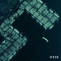
Finnish startup ICEYE launched its global Dark Vessel Detection solution to help governmental maritime security customers monitor their waters for illegal vessel activity.The high-tech solution, which combines synthetic-aperture radar (SAR) satellite data from ICEYE and automatic identification system (AIS) data from vessels, is used as a source of actionable information for governments monitoring their Exclusive Economic Zones (EEZ), day and night, and even through cloud cover.“Dark…
C-MAP Unveils Insight Chart Options
Global cartography leader C-MAP is set to introduce a new series of map products for boaters. The new U.S. mapping products — C-MAP Insight Pro and C-MAP Lake Insight HD — combine the trusted chart detail, unique content and popular graphical presentation of C-MAP cartography with exclusive chart data from GoFree Lake Insight charts. Boaters and anglers using these charts will also benefit from millions of acres of customized data from the Insight Genesis Social Map, providing the most up-to-date views of underwater contours and lake bed features gathered and shared by actual boaters on the water. C-MAP Insight Pro gives both coastal and freshwater anglers powerful features designed to enhance their time on the water.
Smartphone App Aims to Aid Migrant Sea Rescues
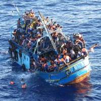
A smartphone application that allows users to scan the Mediterranean for boats in distress is being tested by a migrant rescue service, which hopes that crowdsourced information will help it save more people. The I SEA App, available on iTunes, divides a satellite image of the sea route migrants are taking into millions of small plots which are, in turn, assigned to registered users. Each user then monitors their plot through the app and can send an alert to the Malta-based Migrant Offshore Aid Station (MOAS) and the authorities if they spot potential trouble.
Holding Your Breath
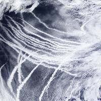
Ship Tracks South of , a satellite image acquired by NASA on March 4, 2009. On March 4, 2009, the skies over the northeast were streaked with clouds that form around the particles in ship exhaust. This pair of images shows how these ship tracks are different from the natural marine clouds in the same area. The top image is a natural-color (photo-like) view of the ship tracks. The image below reveals more information than a picture: it shows the size of the cloud droplets. Both…


