Outdated Artic Charts Serve As a Threat

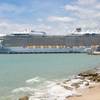
According to cbsnews.com, Melting sea ice has drawn more cruise ship tourists to Canada's Arctic waters, but an Arctic security expert warns that centuries-old navigation charts still in use today could threaten the safety of such vessels and their passengers.
Ships still rely on some maritime charts that date back to the voyages of the British Arctic explorer Sir John Franklin in the 1800s, said Rob Huebert, a political science professor at the University of Calgary.
Navigational technology was limited in Franklin's time, Huebert said, leading to vague or inaccurate chart measurements.
In August 1996, the Hanseatic cruise ship ran aground near Cambridge Bay, Nunavut, as it was carrying tourists in the Northwest Passage. No one was injured in that incident.
More recently, the Canadian cruise ship MS Explorer struck an iceberg and sank in the Antarctic on Nov. 23, forcing its 154 passengers and crew including 12 Canadians into lifeboats in the middle of the night.
Such cruise-ship accidents rarely happen, so potential northern cruise-goers need not worry. But he said the lack of modern charts is one risk travelers may want to consider.