

Coast Guard Discontinues Differential GPS Broadcast
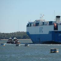
On June 30, 2020 the Coast Guard switched off the last Differential Global Positioning System (DGPS) signals after more than 25 years of service.With the improved accuracy and integrity of un-augmented GPS over the last several years, and with the introduction of the U.S. operated satellite-based augmentation system known as Wide Area Augmentation System (WAAS), the maritime community no longer has a mission requirement for DGPS. GPS now provides sufficient positional accuracy…
ScanjetPSM Launches Digital Sextant

A new Digital Sextant has been engineered to provide back-up navigation in the event of failure or malicious adjustment of the GPS system, says manufacturer ScanjetPSM.The Digital Sextant provides a simple to use solution that requires no specialist training and is capable of delivering accurate readings within one second of sighting, without the need for additional charts or tools. It enables fast, accurate identification of position with longitude and latitude readings, minimizing the opportunity for operator error and providing and recording the location within seconds.
Venezuelan Detains More than 30 PDVSA Workers
At least 38 workers from Venezuela's state oil company Petroleos de Venezuela’s, including the president of maritime subsidiary PDV Marina, were detained on accusations of trafficking fuel, Venezuelan Interior Minister Nestor Reverol said on Saturday, describing the accusations as "treason."The move comes just days after other state officials were detained and amid a shakeup at PDVSA after President Nicolas Maduro last month named a committee to restructure the OPEC nation’s oil industry, which is struggling under U.S. sanctions designed to force Maduro’s ouster, as well as years of mismanagement, corruption, and declining cash flow.On Friday…
Maritime GPS Users, Remember 6 April 2019
Maritime users of the Global Positioning System Standard Positioning Service (GPS-SPS) are urged to check their systems ahead of the week counter roll over on 6 April 2019, informed International Maritime Organization (IMO).Some outdated GPS receiver systems may cease to function properly - with potentially serious impacts on navigation, the UN body pointed out.The roll over occurs because the GPS system transmits time to GPS receivers using a format of time and weeks as a 10-bit value, which started from 6 January 1980, and can only count 1023 weeks.The previous roll over was on 21 August 1999, when systems reset and began counting towards week 1023 again.
GPS Rollover April 6, 2019: Are you ready?

Maritime users of the Global Positioning System Standard Positioning Service (GPS-SPS) are urged to check their systems ahead of the week counter roll over on 6 April 2019. Some outdated GPS receiver systems may cease to function properly - with potentially serious impacts on navigation.The roll over occurs because the GPS system transmits time to GPS receivers using a format of time and weeks as a 10-bit value, which started from 6 January 1980, and can only count 1023 weeks. The previous roll over was on 21 August 1999, when systems reset and began counting towards week 1023 again.
RIB Circumnavigates Iceland in 42 Hours
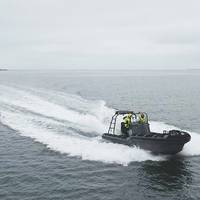
Al Seer Marine and Rafnar, Icelandic marine technology innovators and designers of the Rafnar Hull, have completed a record-breaking 42-hour circumnavigation of Iceland.This news follows the firms' recent partnership announcement for the licensing of the Rafnar Hull. The challenge of circumnavigating Iceland in a small open RIB was an opportunity for Al Seer Marine to gain firsthand experience of the Rafnar Hull in the conditions that shaped it. The journey began in Reykjavík, Iceland, on Thursday, May 31, 2018 at 1:20 p.m. and ended on Saturday, June 2nd at 8:00 a.m. in Reykjavík.
US Coast Guard to Discontinue Remaining DGPS Sites
The U.S. Coast Guard announced today it will discontinue broadcasts from its remaining 38 Differential GPS (DGPS) sites over the next three years, completing system reductions that began in 2016. The staged reduction of the remaining Coast Guard DGPS broadcast sites will begin in 2018 and end with the last broadcast of GPS corrections over medium frequency in 2020. The U.S. Coast Guard Navigation Center has operated the Nationwide DGPS Service since 1999 to broadcast correction signals on marine radiobeacon frequencies to improve the accuracy and integrity to GPS-derived positions. Lt. Cmdr. “GPS provides sufficient positional accuracy to meet navigation requirements for harbor approaches and to position Federal Aids to Navigation,” Patterson said.
Port of Gothenburg Enhance Efficiency Through Digitalisation
The Port of Gothenburg has implemented what has amounted to a major surge in automation, governing large-scale pumping between terminals and refineries. The new system will ensure the terminals receive rapid, concise notification about when pumping can take place, and they can also see the exact cost on completion. The process will save both time and money. The Port of Gothenburg is the largest open access energy port in Scandinavia and is renowned internationally for its safety initiatives. Some 2,500 tankers call each year, handling crude oil, petrol, diesel and other energy products. “In 2016, we broke the record when 23.7 million tonnes of oil passed through the port. If it wasn’t for a scheduled maintenance shutdown, we would have more than surpassed that figure during 2017.
Cyber Threats Prompt Return of Radio for Ship Navigation

The risk of cyber attacks targeting ships' satellite navigation is pushing nations to delve back through history and develop back-up systems with roots in World War Two radio technology. Ships use GPS (Global Positioning System) and other similar devices that rely on sending and receiving satellite signals, which many experts say are vulnerable to jamming by hackers. About 90 percent of world trade is transported by sea and the stakes are high in increasingly crowded shipping lanes.
Fast Small Ship Simulator

Bouncing over the waves at a speed of 43 knots, the director of the Defense Materiel Organization (DMO) Vice Admiral Arie Jan de Waard, and MARIN’s director Bas Buchner, made the first test voyage on the moving ‘Fast Small Ship Simulator.’ This FSSS is built by MARIN and SME partners, Cruden and TreeC, as part of a CODEMO project to stimulate the development of a prototype. Vice Admiral De Waard felt the test was very realistic and said: “You feel as if you are involved in a complex operation at sea.
Ejde Loran Station Shut Down on Faroe Islands

The Ejde Loran station on the Faroe Islands will be shut down on December 31, 2015, after having been in operation since 1959. At the end of the year, the entire European Loran system will be discontinued. The Loran-C station on Ejde is a part of the Northwest European Loran system, consisting of four stations in Norway, two in France, one in England, one stationin Germany as well as the station on the Faroe Islands. Loran-C is a radio navigation system that can be used for navigation and the receipt of time information if you have a Loran-C receiver.
RECAB: Power in Computing

“RECAB is a provider of rugged computers; we are a hardware company,” said Bjørn Espen Aase, Managing Director, RECAB Norway. We met with RECAB at the recent Norshipping in Oslo to catch up with this fast-growing computer integrator, a company which sees its business spread across many industries that demand high-performance rugged computing. “We are a typical subcontractor for the big players like Kongsberg and Rolls-Royce, for example. We are enabling world-class applications so they can put their software on top and integrate with the sensors.
Garamendi Introduces Bipartisan GPS Backup Bill

Congressman John Garamendi (D-Fairfield, CA), the Ranking Member of the House Transportation and Infrastructure Subcommittee on the Coast Guard and Maritime Transportation, introduced the bipartisan National Positioning, Navigation, and Timing (PNT) Resilience and Security Act of 2015, H.R. 1678. H.R. 1678 would require the Secretary of Defense, in coordination with the Commandant of the Coast Guard and the Secretary of Transportation, to establish and sustain a reliable, land…
Fuel Tax Dilemma Solved for Inland Fleets
Operating commercial vessels on inland waterways requires accurate fuel consumption tracking for paying an array of fuel use taxes under the Inland Waterways Revenue Act in addition to those imposed by states and local jurisdictions. In most cases, these taxes apply only to fuel used for propulsion and is based on gallons burned while transiting specific areas. The complexity of tracking fuel burned for tax purposes has been time consuming and sometimes little more than guesswork, neither of which are good procedures for fleet operators. FloScan’s proprietary DataLog Fuel Monitoring Software, included at no-charge with every FloNET Fuel Monitoring System…
Europe Grapples with Threat of Ships Sailing Blind
Europe has yet to fully wake up to the danger of maritime disasters caused by signal jamming and blackouts of satellite navigation devices, say the proponents of a back up system on trial in British and Dutch ports. Ships increasingly rely on systems that employ satellite signals to find a location or keep exact time including the Global Positioning System (GPS) and GLONASS. But experts say such systems are vulnerable to signal loss from solar weather effects or radio and satellite interference and can also be affected by intentional jamming by criminal gangs, nation states or potentially from militant groups. The General Lighthouse Authorities of the UK and Ireland (GLA) is pioneering a radio-based back-up prototype called eLoran.
New Ship-based System Takes Out GPS Jamming Threat
With GPS jamming a growing worry for UK shipping, a new device seamlessly switches systems to counter the navigational menace. In development since 2005, the ACCSEAS project used a system on the vessel THV Galatea in the seas off Harwich to show that the PNT (Positioning, Navigation and Timing) technology was resilient enough to withstand the worst case scenario of a ship suddenly losing all GPS signals, reports PC Advisor. In theory it would be possible to simply turn off a GPS system and switch on the powerful, longwave eLoran (eLOng RAnge Navigation), but in the middle of a busy shipping lane sea captains don't necessarily realise what is happening to them quickly enough.
Allure of the Seas Delivered
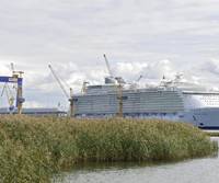
On October 28, 2010, Turku Shipyard delivered the Allure of the Seas to Royal Caribbean International. The Allure of the Seas and its sistership Oasis of the Seas are the culmination of more than 40 years of product development cooperation between the cruise line, the shipyard and the maritime cluster. The 225,000-ton Oasis class vessels are 361m in length. The Allure of the Seas can accommodate 6,360 passengers at maximum. In comparison, the Song of Norway delivered to the same customer in 1970 was 168m long with a gross tonnage of 18…
IMS Introduces Deep Digging Dredger

IMS introduces the deep digging Depth Master 55 (DM-55TM) as the latest addition to is dredge product line. The DM-55TM is IMS's solution to making deep maintenance dredging and environmental dredging affordable. "Over the years we have received hundreds of inquiries from ports and environmental contractors wanting to dredge deeper, but they simply could not afford to get a multi-million dollar machine and have resorted to ineffective pumps on wires and water injection vessels that don't create an even bottom profile," says IMS Division President, Jim Horton. "The DM-55TM solves this issue.
Monitoring System Takes Guesswork Out of Mooring Mega Vessels
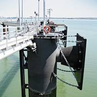
Mooring of large vessels in the LNG, petrochemical and container sectors is an intricate and critical procedure. The process entails bringing together a moving object with a static object, and with the imminent advent of even larger vessels (liquefied natural gas tankers with a capacity of 200,000 cubic meters and container ships with a capacity of 22,000 TEU*), the forces involved are enormous. For tankers and bulk carriers, mooring frequently takes place alongside jetties at the end of finger piers…
LightSquared Outlines Plan to Avoid GPS Interference

Marine electronics industry still has major concerns. An official of LightSquared, the company that has been under fire for its plan to offer mobile satellite services that could seriously interfere with Global Positioning System (GPS) signals, told a gathering at the 2011 NMEA International Marine Electronics Conference & Expo that solutions were in the works to prevent disruptions from occurring. “Our integrated network will bring great benefits to wireless users nationwide, but at the same time we’re committed to ensuring this service doesn’t interfere with any GPS devices.
Trelleborg Patent Pending for Fender Load-Monitoring Systems
Trelleborg Marine Systems, a manufacturer of docking, mooring and berthing equipment, has received patent pending status on a system for monitoring the load on marine fenders. The new system is designed to help avoid disputes and the costly downtime associated with insurance claims. The marine fender load-monitoring system can be used to measure both the impact on fenders when a vessel berths, and the ongoing force applied as the vessel continues to bear against them while docked. “The data collected by this system could prove to be invaluable to ports and harbors all over the world in avoiding disputes and the costly downtime associated with insurance claims,” said Trelleborg Marine System’s Technical Director, Scott Smith.
Korean Shipyard Gets Orders for Two Liftboats
The value of this contract is approximately US$ 1.1 billion and the rigs will be delivered in the middle of 2015. After delivery, these rigs will be chartered by Statoil, the Norwegian state oil company for eight years, and they will provide services to the Norwegian Coast, the North Sea, and Polar Regions. Statoil is operating a ‘Category-D’ oil well exploitation project on the Norwegian continental shelf and it will be possible for these rigs to drill up to a maximum depth of 8,500m in 100~500m of water. These semi-submersible rigs will be 116m long, 97m wide, and fitted with the Dynamic Positioning System which includes a GPS system.
China's GPS 'Beidou' to be Enhanced
The Third China Satellite Navigation Conference in progress in Guangzhou, South China’s Guangdong Province, with satellite experts, government officials and business executives from China, the US, Russia, Europe and Japan participating in the event.The Beidou system chief designer, Sun Jiadong, said China will expand the Beidou satellite navigation service across the entire country. Beidou is a satellite navigation system developed by China and has been providing services since the end of 2011. The conference is a key stage for China to exchange knowledge with the world about satellite navigation know-how and to enhance innovation of its own satellite techniques.


