

Navigating Climate Change: How Shipping is Adapting in the St. Lawrence
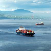
When compared to other major river navigation routes around the world, the St. Lawrence River is a favored waterway.It flows from the mouth of Lake Ontario, at an altitude of 250 meters. From its source to the Gulf, the river travels 1,197 kilometers, and is fed by several tributaries including the Ottawa, Richelieu, Saint-François and Saguenay rivers.But the effects of climate change are being felt. The marine industry is adapting. It is currently embarking on a shift towards…
Work‘bots’: Autonomous Vessels Arrive
The near-shore and inland workboat fleet is at the leading edge for autonomous vessel developmentWhile the advent of autonomous workboats are not exactly mainstream, you better believe that in the not-too-distant future they will be a reality on waterways in and around the U.S. Today there remain more questions than answers, particularly on the legal, logistics and insurance side of the coin. But the technology is evolving at record pace, providing many in the industry with mixed emotions. Excitement. Controversy. Curiosity. Skepticism. These are just a few of thoughts, and emotions that arise to any mention of the topic of autonomous vessels.It’s happening now.
Hydrographic Survey Vessel Converted for Autonomous Ops
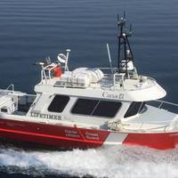
ASV Global said it has converted a 26ft hydrographic survey launch to enable it to operate autonomously using the ASView control system, while maintaining its ability to operate in a conventional manned mode. The launch, which is part of the Canadian Coast Guard’s (CCG) fleet dedicated to the survey operations of the Canadian Hydrographic Service (CHS), will be used as a test platform for unmanned survey work. This delivery to the CHS marks ASV Global’s 10th unmanned conversion of a customer vessel using the ASView system.
iNavX Debuts IN-APP Charts, Maps Purchase Capability
iNavX, the benchmark marine navigation mobile application, in partnership with Fugawi X-Traverse, today launched its chart and map in-app purchase program. Now enabled with one-touch purchase and download, iNavX gives boaters the most streamlined access to the broadest set of marine charts and maps from multiple providers. iNavX users will gain intuitive download capabilities for all of their favorite chartsand navigation data such as Navionics’ worldwide chart catalog, Canadian Hydrographic Service (CHS) charts; Fugawi Aboard quilted Canadian and US charts; NV Charts for Europe, the US and the Caribbean; Theyr weather; Waterway Guide…
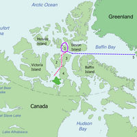
Canada Embarks on Arctic Survey Mission
Canada has launched its 2016 Arctic expedition to collect important scientific information to support the nation’s submission on the extended continental shelf in the Arctic Ocean. This year’s survey is a collaborative effort with Sweden, and Danish scientists will also participate in the research. The Canadian icebreaker CCGS Louis S. St-Laurent left Dartmouth on July 22, 2016, for Tromsø, Norway, where it will take on board personnel from Natural Resources Canada’s Geological Survey of Canada…
Canada to Build 7 New Survey Vessels
Canadian Minister of Fisheries, Oceans and the Canadian Coast Guard, Hunter Tootoo, announced that Kanter Marine Inc. of St. Thomas, Ontario is the winning bidder for the procurement of seven new survey vessels for the Canadian Hydrographic Service to support the seabed surveying and charting of Canada’s navigable waters. The $5.3 million investment will go toward customized hydrographic survey vessels that will be outfitted with permanent state-of-the-art multibeam sonar systems to help the Canadian Hydrographic Service continue to meet rigorous international standards for hydrographic surveys. Once built, the seven new vessels will be added to the existing survey vessel fleet located across Canada. The new vessels will be employed to collect data in the St.
Canadian Government Unveils 3D Model of HMS Erebus
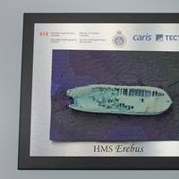
A partnership between Canadian government and private industry today unveiled high precision 3D printed models of HMS Erebus, Sir John Franklin’s lead ship found last year in Canada’s Arctic waters as part of Parks Canada’s search for the vessels of the lost 1845 expedition. The model was unveiled in Fredericton, New Brunswick. Officials from Fisheries and Oceans Canada joined with Canadian geospatial software company CARIS and geomatics technology innovation support centre TECTERRA to unveil the models.
French Coast Braced for Giant Tide
Towns on France's North Atlantic coast braced for their first giant tide of the millennium on Saturday as the full moon and this week's solar eclipse combined to create an ocean surge not seen since 1997. At the picturesque Mont Saint Michel island where some of the biggest tides in the world occur, visitors gathered to watch the tide disappear out of sight, exposing areas of beach and rock visible only every 18 years. The next peak tide is not due until 2033. France's National Hydrographic Service was expecting to measure more than 14 metres (15.3 yards) between low and high water around the famous Abbey-topped rock off France's north-west coast. Average tides in the area measure 8.7 metres.
Bell Recovered from Wreck of HMS Erebus
The ship's bell recovered from the recently discovered Franklin Expedition shipwreck, HMS Erebus, was unveiled by the Honorable Leona Aglukkaq, Minister of the Environment and Minister responsible for Parks Canada. The artifact was recovered during dives and archaeological investigation by Parks Canada's underwater archaeology team in September. The bell was found on the deck adjacent to the ship's displaced windlass (a form of anchor winch), above which it was originally mounted. Since then, the bell has been undergoing conservation stabilization and additional research.
Fugawi Aboard Combines US, Canada Raster Charts
Fugawi Aboard, a newly launched product from Northport Systems Inc., combines U.S. and Canadian raster charts, based on National Oceanic Atmospheric Administration (NOAA) and Canadian Hydrographic Service (CHS) nautical charts, into quilted regions for use on compatible chartplotters. Fugawi Aboard combines more than 2,000 NOAA and 600 CHS raster navigation charts on one quilted product. Packed with coastline detail for the entire United States and Canada, Fugawi Aboard delivers the look and feel of vector charts with the unmatched detail and familiarity of paper charts.
Canada Launches Surveys Prior to Arctic Shelf Claims
The Canadian Government informs that David Wells, Senator for Newfoundland and Labrador witnessed the departure of the 'CCGS Terry Fox' from St. John’s, Newfoundland and Labrador, as it headed out on a six-week scientific survey to collect data needed for Canada’s Arctic continental shelf submission. It will be joined by the 'CCGS Louis S. St-Laurent', which departs from the same location tomorrow. A second survey, to collect additional data, will be conducted in 2015. “As demonstrated by these planned surveys, our government is committing the resources necessary to ensure that Canada secures international recognition of the full extent of its continental shelf, including the North Pole,” said Foreign Affairs Minister John Baird. The CCGS Terry Fox will break ice so that the CCGS Louis S.
Fugawi Announces Android Support Via Pathaway
Northport Systems Inc., creators of Fugawi X-Traverse, and Muskoka Tech Inc., developers of PathAway GPS navigational, mapping and tracking software for mobile smartphones and tablets, announced today greatly expanded chart support for Android mobile devices. With the latest version of PathAway for Android, users with a Fugawi X-Traverse Cloud Passport now have access to 82 different product offerings including the latest in marine charts, weather information, and topographic maps. In order to ensure the very best mobile navigation experience for adventures anywhere in the world, X-Traverse offers charts and maps from a wide variety of vendors, such as NV Charts, WaveyLine, Solteknik, the Canadian Hydrographic Service, and Fugawi.
Kongsberg Maritime's Double Whammy 200th Anniversary
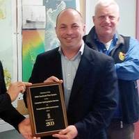
Kongsberg Geoacoustics informs it has delivered its 200th Geoswath Plus on Kongsberg Maritime’s 200th anniversary. Nick Burchill, Subsea Sales Manager for Kongsberg Maritime in Canada presented a plaque to Denis D'Amours, Director of the Canadian Hydrographic Service's Pacific Region, which uses the equipment, in honour of the occasion. The Canadian Hydrographic Service uses its GeoSwath Plus systems for shallow water mapping when a high rate of coverage is required. According to Ken Halcro…
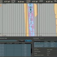
Transas: Draft Information System
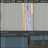
At the St. Lawrence Seaway is one of the most important transportation links in North America. To maximize the efficient use of the seaway, in 2001, the Seaway authorities started to a study which would determine the maximum load ships can carry while maintaining a safe Under-Keel Clearance (UKC). Over the years the maximum draft of vessels transiting the Seaway in the MLO Montreal to Lake Ontario and the Welland Canal has been gradually increased. At the opening of the Seaway in 1959, the maximum draft for ships was set at 6.85 meters (22.5 ft. ). This maximum draft is now set at (26.5 ft.).
Northwest Passage Wrecks Hunt Launched
The Canadian government launches its largest search yet for the lost ships of Sir John Franklin's doomed 1845 quest for the Northwest Passage. This year's search, led by Parks Canada, is the fourth government-led expedition over the past five years, and is by far the biggest, involving a much larger alliance of federal departments and other public and private interests. A previous large-scale search for the Franklin ships was launched by National Defence in 1967 as part of Canada's centennial.
Transas St. Lawrence Seaway Draft System Approved
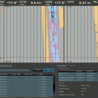
Transas Marine receives approval for Saint Lawrence Seaway Draft Information System. The St. Lawrence Seaway is one of the most important transportation links in North America. To maximize the efficient use of the seaway, in 2001, the Seaway authorities started to a study which would determine the maximum load ships can carry while maintaining a safe Under-Keel Clearance (UKC). Over the years the maximum draft of vessels transiting the Seaway in the MLO Montreal to Lake Ontario and the Welland Canal has been gradually increased.
Transas Gets Approval for Saint Lawrence Seaway Draft Information System
The St. Lawrence Seaway is one of the most important transportation links in North America. To maximize the efficient use of the seaway, in 2001, the Seaway authorities started to a study which would determine the maximum load ships can carry while maintaining a safe Under-Keel Clearance (UKC). Over the years the maximum draft of vessels transiting the Seaway in the MLO Montreal to Lake Ontario and the Welland Canal has been gradually increased. At the opening of the Seaway in 1959, the maximum draft for ships was set at 6.85 meters (22 feet 6 inches ).
New Practices Will Lead to Safer Passage in Arctic Waters
Highlighting the need for safer navigation in Canada’s Arctic, the Transportation Safety Board of Canada (TSB) released its report into the August 2010 grounding of the cruise ship, Clipper Adventurer in Coronation Gulf, Nunavut (M10H0006). "Our investigation determined there were problems with the vessel’s voyage planning but we also found that key safety information was not being proactively provided to vessels transiting the Arctic,” said TSB Investigator-in-Charge, Eric Asselin. “Traffic in these fragile waters is increasing.
MetalCraft Building Multi-Beam Hydrographic Survey Craft
MetalCraft Marine Inc., of Kingston, Ontario, is nearing completion of its second Hydrographic Survey Craft for the Canadian Government's Department of Fisheries and Oceans (DFO), Canadian Hydrographic Service. The 30 x 10.3 ft. vessel will carry three transducers, the largest being a state of the art 332 mm Multi-beam Transducer by Kongsberg-Simrad, Model EM-3000. The total Multi-beam system is worth approximately three times the value of the vessel, which was sold for $129,000. The Canadian Hydrographic Service, Central and Arctic Regions is responsible for updating and validating Canadian navigational charts for all inland and Arctic waters, including the Great Lakes and the St. Lawrence Seaway.
Q-Mar Partners With Socomar
Q-Mar, specialist in the development of ECDIS for the naval and hydrographic sectors, has formed a partnership with Socomar International to integrate its industrial and commercial activities. The management of both firms is under the direction of president and CEO, J.L. Paul Dionne. Socomar International is a Canadian provider of turnkey management information and navigation systems for the marine geomatics and environment sectors. The company specializes in sensors and integrated systems, vessel traffic systems, geo-spatial data infrastructure (GSDI) systems. Q-Mar has also signed a dealer license agreement with Nautical Data International (NDI) to license and distribute electronic charts from the Canadian Hydrographic Service.
Q-Mar Partners with Socomar
Q-Mar, specialist in the development of ECDIS for the naval and hydrographic sectors, has formed a partnership with Socomar International to integrate its industrial and commercial activities. The management of both firms is under the direction of president and CEO, J.L. Paul Dionne. Socomar International is a Canadian provider of turnkey management information and navigation systems for the marine geomatics and environment sectors. The company specializes in sensors and integrated systems, vessel traffic systems, geo-spatial data infrastructure (GSDI) systems. Q-Mar has also signed a dealer license agreement with Nautical Data International (NDI) to license and distribute electronic charts from the Canadian Hydrographic Service.
Smooth Sailing
The entire suite of 1,000 official NOAA nautical charts has been available in digital raster form since 1995. These high quality, full color, geo-referenced images of NOAA's paper charts are made for use in computer-based navigation systems and work with GPS or other electronic positioning systems. They are produced jointly by NOAA and Maptech, Inc. under a cooperative research and development agreement (CRADA). Mariners quickly adopted raster nautical charts. Their rapid adoption was aided by first-rate navigation software available from many companies at an affordable price. Today, the raster charts outsell NOAA's paper charts by eight to five.
CHS Agreements with Jeppesen Marine
Jeppesen Marine signed two license agreements with the Canadian Hydrographic Service (CHS) in May. The first is a CHS Value-Added Reseller (VAR) agreement authorizing Jeppesen Marine to integrate CHS products and updates into its own value-added products for the marine industry. The second agreement makes Jeppesen Marine an authorized dealer of official Canadian Hydrographic Service Digital Charts, including CHS Electronic Navigational Charts (ENCs) and BSB raster charts, and also allows Jeppesen Marine to issue CHS ENCs in type-approved SENC format. “We’re happy that our CHS products will be available through Jeppesen Marine’s global reseller network,” said CHS Dominion Hydrographer Dr. Savithri Narayanan. “Jeppesen Marine’s products are popular in the Canadian marketplace.


