

ChartWorld Extends Portfolio to Support GIS Customers
ChartWorld now offers OceanWise Marine Themes dataset that combines the fragmented features of traditional nautical charting merged into an almost seamless marine map. The data is more beneficial and overcomes the irregular coverage and multi scale levels of traditional charting products. In particular those users who intend to add third party datasets or other outputs such as Web Services will benefit from Marine Themes. The Digital Elevation Model (DEM) makes Marine Themes an advanced dataset for use in desktop and WebGis.
Nv Charts Launches New ‘Virtual Chart Shop’ Web Site
Nv Charts announced the launch of nvcharts.com, a new interactive web site and e-commerce site for all of the company’s charting and navigation products, customer service, and all things Nv. The new website features an improved homepage design, cleaner layout of page content, and an intuitive and consistent site-wide navigation system. It is also accessible through a wider range of web browsers and devices, including mobiles and tablets. “Our new site is a virtual chart shop online…
New Bermuda Islands Paper and Digital Charts
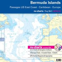
Cruising sailors visiting Bermuda now have a new, up-to-date, remarkably detailed set of charts for the islands in both paper and digital format, exclusively from nv-charts, a global supplier of precision charting products for mariners. The new Bermuda chart set, Region 16.1, is the latest and most complete charting package for the navigationally-hazardous Bermuda islands to appear in many years, and is more complete and detailed than the limited charting resources for Bermuda that have been available for so long.
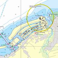
Nv-Charts Launches New Chesapeake Bay Chart Sets
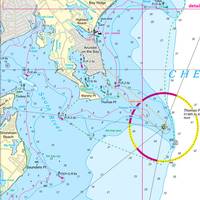
Newport, Rhode Island – Nv-Charts, a global supplier of charting products for mariners and cruising sailors, has now extended its coverage and produced new chart regions for Chesapeake Bay, just in time for the 2012 cruising and boating season. The coverage is divided into two regions, North and South. The North region includes Delaware Bay and the Chesapeake-Delaware canal, coverage from Cape May, N.J., to the Potomac River; and the Southern region continues down to Norfolk and the surrounding environs.
nv-charts Now Available for Cuba
nv-charts, a global supplier of precision charting products for mariners and cruising sailors, has now extended its coverage and produced new chart regions for the North Coast of Cuba. The coverage is divided into two regions; the northwest coast chart set is Region 10.2, and the Northeast coast is Region 10.1. Cruisers interested in visiting Cuba and navigating the northern coast safely will be especially pleased at the availability of NV Charts’ two regions, NW and NE, because they are simply not available anywhere else.
Navy, NOAA, USCG Sign Memorandum of Understanding
By Lt. j.g. Top officials from the U.S. Navy, the National Oceanic and Atmospheric Administration (NOAA) and the U.S. Coast Guard signed a Memorandum of Understanding July 21, reaffirming their support of the National Ice Center (NIC). The NIC, an interagency office jointly operated by the Navy (Naval Ice Center), NOAA and Coast Guard, provides strategic and tactical ice analyses and other services that aid the navigation of U.S. vessels in ice-infested waters. “Today’s update to our original working agreement, first signed in 1995, means that the National Ice Center can continue monitoring the waterways for potentially dangerous ice and help guide ships out of harm’s way for the safe, efficient delivery of goods,” said retired Vice Adm. Conrad C.
Chartco: The Best of Both Worlds
Created just three years ago, Chartco embraces a small company's flexibility and innovative attitude but is supported by a big company bankroll. Dr. Andy Norris, Chartco's managing director, recently spent some time with MR/EN to discuss the present and future of electronic charts. The realization of electronic charts replacing their paper brethren has been slow in coming, to say the least. For a number of technical, political and economic reasons, the fight to develop and implement a universally acceptable solution and standard has yet to be accomplished. This is not to say, though, that tremendous strides have not been taken, as the quantity and quality of electronic charting products and systems has grown exponentially in recent years. Despite the numerous stops and starts, Dr.


