

Nautilus Labs Partners with OrbitMI
Nautilus Labs, the technology firm unlocking profitable decarbonization for the ocean supply chain, and OrbitMI, a global provider of maritime software and data products to accelerate digital transformation in maritime, announced their partnership to serve the industry with a comprehensive solution to manage data integrations, operational processes, and optimizations for improved commercial and environmental outcomes.Joint clients of the newly formed partnership can access Orbit Reporter – a flexible…
Global Reef Expedition: Mission to Tonga

Assessing the health of coral reefs in the Kingdom of TongaHealthy coral reefs provide critical ecosystem services for millions of people globally, but with climate change and anthropogenic stressors, the landscape of these habitats is regularly shifting. The science and conservation community has realized the importance of baseline studies to help track how these precious reef ecosystems are changing. The Khaled bin Sultan Living Oceans Foundation launched the Global Reef Expedition…
Indian Navy Signs MoU for Offshore Data with GSI
Indian Navy has signed a memorandum of understanding (MoU) with Geological Survey of India (GSI) for ‘sharing of seabed sediments data, products and expertise for Naval application in meteorology and oceanography’.The MoU was signed on 21 January 2020 between Commodore AA Abhyankar, who heads Indian Navy’s Oceanology and Meteorology Directorate and Shri N Maran, Deputy Director General of GSI.GSI’s Marine and Coastal survey Division based at Mangaluru has mapped most of India’s 2.1 Million square km Exclusive Economic Zone and has a vast repository of offshore data.This data collected using GSI’s state-of-the-art oceanic research vessels Samudra Manthan…
BSEE Retains TGS
Norwegean surveying services company TGS-NOPEC Geophysical Company (TGS) has been awarded a five-year contract for Digital Well Log Data Processing with the United States Department of the Interior, Bureau of Safety and Environmental Enforcement (BSEE), a federal agency tasked with overseeing offshore oil and gas activities.TGS has been providing Digital Well Log Data Processing services to BSEE since 2004, said the provider of multi-client geoscience data to oil and gas Exploration and Production companies worldwide.BSEE requires complete, defect-free sets of processed, high-quality open-hole digital well log data and contracts companies to serve as an agent of BSEE for the processing…
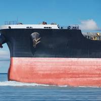
Kongsberg Inks First Deal for HUGIN Superior

Kongsberg Maritime reports it has signed the first contract for the new HUGIN Superior 6,000-meter rated autonomous underwater vehicle (AUV).According to its manufacturer, the HUGIN Superior, introduced to the market in December 2018, is engineered to provide significantly enhanced data, positioning and endurance capabilities while building on the proven track record of the HUGIN AUVs. The complete AUV system will be delivered in DNV certified offshore containers along with a…
Globalstar Joins SIA
The Satellite Industry Association (SIA) announced that Globalstar is the latest company to join SIA. Globalstar operates a low-earth-orbit (LEO) constellation of satellites and provides mobile satellite voice and data products and service packages to government, industry and consumer customers around the world. The Company’s products include mobile and fixed satellite telephones, the Sat-Fi satellite hotspot, Simplex and Duplex satellite data modems, tracking devices plus its subsidiary SPOT LLC family of consumer satellite products. In September, Globalstar announced the appointments of Dave Kagan to the position of CEO and Jay Monroe to Executive Chairman of the Company’s Board of Directors and earlier this year the Company introduced two new products…
EMEC Metocean Data to Stimulate Inovation
The European Marine Energy Centre (EMEC) has provided a series of metocean data sets to be used in a new Scottish open innovation competition aiming to stimulate creative thinking and data science to design new data products for the benefit of the marine environment, communities and economy.Organized by Highlands and Islands Enterprise (HIE) and the Data Lab, Scotland’s Blue Growth Data Challenge will make available data sets from 2015 in-situ observations and numerical modelling from EMEC’s wave and tidal energy test facilities in Orkney.The data sets include wave conditions at EMEC’s Billia Croo wave test site; meteorological observations in two locations adjacent to EMEC’s wave and tidal test sites…
Marine Mapping Agreement for Northern Ireland
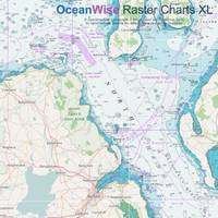
OceanWise announced that it has been awarded a contract to provide the Government of Northern Ireland with marine mapping. The award reinforces OceanWise as the primary supplier of marine mapping to both the public and private sectors in the U.K. The agreement includes Marine Themes, Marine Themes DEM and Raster Charts XL (eXcluding Land) provided in the form of datasets and as OGC compliant web services. The data will be used to support desktop GIS and as input to web based applications.
ChartCo Acquires Marine Position
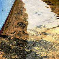
ChartCo, a global supplier of maritime digital data and compliance services, has announced its acquisition of the Swedish environmental shipping technology expert business Marine Position. The transaction extends ChartCo's core product strategy of providing a centralized digital platform on board vessels which is linked to key shoreside activities. Marine Position AB is a global specialist provider of maritime environmental regulations and compliance covering international, national and local requirements.
Baltic Exchange Names Sykes Chief Commercial Officer
The Baltic Exchange has appointed a new chief commercial officer; Janet Sykes, former head of communications at shipping services provider Clarksons Platou, will join the Baltic Exchange on July 3. Sykes worked at Clarksons Platou between 2010 and 2017 where she was responsible for all internal and external communication and marketing. She was previously head of marketing at the Baltic Exchange (2001-2010) and has previously worked as shipbroker at Howe Robinson (1991-2000). Baltic Exchange chief executive, Mark Jackson, said, “We're delighted that Janet Sykes will be joining the team. She has global shipping experience with a strong focus on the derivative markets and data products.
OOI Community Workshop: Cabled, Endurance, and Station Papa
The Ocean Observatories Initiative (OOI) infrastructure is operational and ocean scientists can now integrate OOI observations into their research proposals and projects. The UNOLS Ocean Observing Science Committee (OOSC) along with OOI’s Science Oversight Committee (SOC) are organizing a workshop that will focus on current and future science addressed by the extensive OOI infrastructure in the Northeast Pacific. This includes the OOI Cabled, Endurance, and Station Papa Arrays. Early science successes from OOI will be highlighted, as well as Ocean Networks Canada (ONC) and NOAA projects focused on furthering scientific understanding of coastal and offshore processes.
BMT Delivers Metocean Support for Tullow Oil
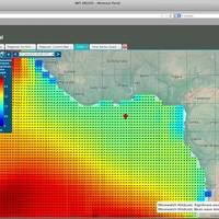
BMT ARGOSS (BMT), a subsidiary of BMT Group, has announced the award of a number of metocean assessments for Tullow Oil Plc., including comprehensive overviews of meteorological and oceanographic conditions in West Africa and South America, to help support the company’s offshore oil and gas exploration and operating activities. Colleen Abell, Senior Environmental Remote Sensing & GIS Specialist at Tullow Oil Plc commented, “Tullow have been engaging with BMT ARGOSS with regards to their metocean and regional reporting capabilities.
ARGUS: Enviable Technology, Unlimited Potential
System is designed to universally interface with a vessel’s existing navigation equipment and autonomously deliver water depths seen by the vessel to a central server. Almost four years and 100 million soundings later, the concept is a reality. Almost two years after we first reported (December 2011 edition of MarineNews) on an innovative, depth sounding recorder device that made wide swaths of data available to perhaps anyone who wants it, the concept envisioned by ARGUS has developed into a viable tool that could change the way that government agencies schedule surveys and dredging. Today, about 40 boats have voluntarily placed on board their vessels the ARGUS (Autonomous Remote Global Underwater Surveillance) system transmitters.
Globalstar Satcom Network Completed
Globalstar, Inc. announce that all second generation satellites are now in full commercial service, completing the world's most modern satellite communications mobile network. Global customer segments include: oil and gas, government, mining, forestry, commercial fishing, utilities, military, transportation, heavy construction, emergency preparedness, and business continuity as well as individual recreational users. The company's new network supports its current lineup of voice…
NOAA Seeks Hydrographic Panel Members
NOAA is seeking qualified candidates to apply for up to five voting member vacancies to serve on its Hydrographic Services Review Panel (HSRP) as of January 1, 2014. The HSRP is a federal advisory committee that advises the NOAA Administrator on current and emerging oceanographic and marine science technologies relating to operations, research and development; and dissemination of data pertaining to: a) hydrographic surveying; b) shoreline surveying; c) nautical charting; d) water level measurements; e) current measurements; f) geodetic measurements; g) geospatial measurements; h) geomagnetic measurements; and i) other oceanographic/marine related sciences.
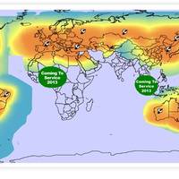
Baron Releases New Weather Software
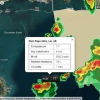
Weather services company Baron Services, Inc. announced the immediate availability of the Velocity Weather API, designed for use by marine industry manufacturers and software developers who want to integrate a weather stream into their final product, including smart phone and tablet apps, websites, MFDs and chart plotters. According to the developer, Velocity Weather API delivers powerful, reliable, location-based and meteorologically accurate weather and atmospheric data via the Internet.
Underwater Survey System Patented
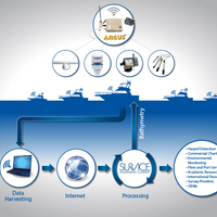
The U.S. Patent and Trademark Office has issued a patent for the ARGUS™ (Autonomous Remote Global Underwater Surveillance) system. The purpose of ARGUS™, which has been in operation and field testing since 2010, is to automate the acquisition and processing of depth, environmental, and meteorological data from coastal and inland waterways and provide the data to Government, commercial, academic, and other interested organizations. The autonomous onboard system (without the need…
New Polar-Orbit Satellite Under NOAA Control
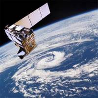
These satellites are critical for advanced warning of severe weather including tornado outbreaks, heavy snowfall, hurricanes, heat waves, floods, & wildfires. Data from the Suomi National Polar-orbiting Partnership (Suomi NPP) satellite will continue to strengthen NOAA’s ability to predict severe weather days in advance. Suomi NPP data are also used to generate dozens of environmental data products, including measurements of clouds, vegetation, ocean color, and land and sea surface temperatures.
Satellites Launched for Mobile Voice & Data Services

Globalstar, Inc. announce that 6 second-generation Globalstar satellites were successfully launched from the Baikonur Cosmodrome in Kazakhstan. Launch services provider Arianespace confirmed that the upper stage accurately injected the six second-generation satellites into their targeted low earth orbit of approximately 920 km. Globalstar reports that all six satellites have been successfully acquired following separation from the Dispenser and Fregat Upper Stage. Globalstar expects to place these final six second-generation satellites into commercial service by this summer…
Snowflake Software to provide GML Encoding
Snowflake Software, specialist in data exchange solutions via Open Standards, has been awarded a contract by the United Kingdom Hydrographic Office (UKHO) to provide an open standard Geography Markup Language (GML) encoding and profile for a basic route specification S-100 based maritime data specification. This work builds on Snowflake’s leading role implementing the International Organization for Standardization (ISO) Model Driven Approach to managed GML application schema design and optimisation for use in practical applications and web services. The International Hydrographic Organization (IHO) technical working group Transfer Standard…
NOAA Panel to Discuss GOM Maritime Issues
NOAA’s Hydrographic Services Review Panel will meet Nov. 27-29 in New Orleans to discuss hydrographic surveying, nautical charting, tides and current measurements, as well as geodetic and geospatial measurements for the Gulf of Mexico region. The three-day meeting is open to the public, and public comment periods are scheduled in the afternoons. The panel will hear from representatives of the regional maritime community, including port authority officials and marine pilots, the geospatial community, and users of NOAA’s tides and currents information.
Traditional Paper Charts in Electronic Format
Seazone Solutions introduce SeaZone HydroView|Charts for use where marine data needs to be displayed rather than analysed. SeaZone HydroView|Charts offer full global coverage, having been created from digitised and geo-referenced paper charts for GIS display, human interpretation and contextual mapping. These raster map layers are available for immediate use in Geographic Information Systems for a range of applications, without the need for additional software, add-ons or plug-ins, resulting in gains in time and performance. HydroView Charts provides ideal backdrop mapping for a variety of applications from desktop to Internet. They can be also combined with existing datasets to make the display and dissemination of maps within reports or over the Internet simple and effective.
NOAA to Hold Public Meeting in Anchorage, Alaska
NOAA's Hydrographic Services Review Panel (HSRP) is holding a Public meeting, May 22-24, 2012, Anchorage, Alaska. Navigation areas of focus for this public meeting include: NOAA's charting and hydrographic surveying products, services and information for the Alaska/Arctic region; and NOAA's geospatial, tide and currents products, services and information. Maritime transportation representatives presenting at the HSRP Anchorage meeting include: the Marine Exchange of Alaska, Crowley Towing, VITUS Marine, Alaska Marine Highway System, Alaska State Digital Mapping Program; as well as, U.S. Army Corps of Engineers, U.S. Coast Guard, Homeland Security, and the University of Alaska.


