

Maritime Autonomy Operational Seminar Launched
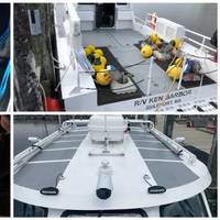
A new seminar is the first maritime autonomy training program to allow the federal workforce to train on state-of-the-art, commercial, off-the-shelf autonomous technologies.Sea Machines Robotics’ in partnership with The University of Southern Mississippi (USM) Roger F. Wicker Center for Ocean Enterprise in Gulfport, Miss. has developed the Maritime Autonomy Operational Seminar through USM's Center of Higher Learning at the John C. Stennis Space Center.Participants plan missions that transform USM's R/V Ken Barbor…
EIVA and Atlas Services Group Join Forces
The international recruitment company Atlas Services Group and EIVA have joined forces by entering into a collaboration agreement that will include training courses on the EIVA software suite in Atlas Services Group’s training curriculum offered globally. Atlas Services Group is an international recruitment company specialising in the energy and marine industry and servicing more than 1,800 candidates worldwide, each day. The company’s hydrographic department in the United Kingdom focuses on this niche market alone and is recognised as the leading global specialist in the supply of high quality professionals to the offshore survey industry. This includes competence development focusing on the skill demands in the industry.
News: C-Map Names Distributor of Singapore ENC Data
C-MAP has been appointed an Official Distributor of Electronic Navigation Charts (ENC) produced by the Maritime and Port Authority of Singapore (MPA) Hydrographic Department. This announcement was made after C-MAP Norway signed an agreement with the MPA. The MPA has been a pioneer in the development of ENCs and is one of the few hydrographic offices that offer complete ENC coverage of national waters supported by an updating service. The waters of Singapore are subject to continual change due to weather and environmental factors. As a result, the MPA surveys the Singapore waters continually. This survey data is collected and included in its navigation chart database on a weekly basis, resulting in a uniquely updated chart database.


