

Kelvin Hughes Rolls Out Its New ECDIS
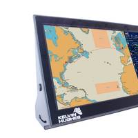
Kelvin Hughes has introduced its latest Electronic Chart Display and Information System (ECDIS) designed for commercial ships as well as naval and coastguard patrol vessels. Available as a standalone ECDIS or as part of a truly multifunction bridge display network with multiple operator positions, the new ECDIS is type approved to meet the latest International Hydrographic Office (IHO) and International Maritime Organization (IMO) standards. It offers an optional mil-spec processor with advanced LED display hardware in a fully integrated, easy to install and retrofit, console package.
News: C-Map Names Distributor of Singapore ENC Data
C-MAP has been appointed an Official Distributor of Electronic Navigation Charts (ENC) produced by the Maritime and Port Authority of Singapore (MPA) Hydrographic Department. This announcement was made after C-MAP Norway signed an agreement with the MPA. The MPA has been a pioneer in the development of ENCs and is one of the few hydrographic offices that offer complete ENC coverage of national waters supported by an updating service. The waters of Singapore are subject to continual change due to weather and environmental factors. As a result, the MPA surveys the Singapore waters continually. This survey data is collected and included in its navigation chart database on a weekly basis, resulting in a uniquely updated chart database.


