

Expedition to Glaciers of Antarctic
How has the West Antarctic Ice Sheet changed in response to alternating warm and cold time periods? And what does it mean for the sea level – today and tomorrow? Pursuing answers to these key questions, 50 researchers on board the Alfred Wegener Institute’s research vessel Polarstern are going to depart from Punta Arenas (Chile) on 6 February 2017, bound for the Amundsen Sea – the region of the Antarctic currently characterised by the most massive and rapid loss of ice. In the course of the expedition, the seafloor drill rig MARUM-MeBo70 will be used in the Antarctic for the first time. Rifts in the Larsen Ice Shelf and the Brunt Ice Shelf, which is home to the UK’s Halley Research Station, are being closely observed.
Huge Iceberg Broken off Antarctica Heads for Open Ocean
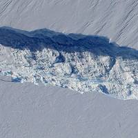
Scientists are monitoring an iceberg roughly six times the size of Manhattan - one of the largest now in existence - that broke off from an Antarctic glacier and is heading into the open ocean. NASA glaciologist Kelly Brunt said on Wednesday the iceberg covers about 255 square miles (660 square km) and is up to a third of a mile (500 meters) thick. Known as B31, the iceberg separated from Antarctica's Pine Island Glacier last November, Brunt added. "It's one that's large enough that it warrants monitoring," Brunt said in a telephone interview, noting that U.S.
Enormous Antarctic Iceberg a Possible Threat to Shipping
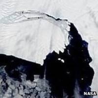
An Iceberg, the size of Manhattan in area, was derived from the Pine Island Glacier, and is currently moving through the Southern Ocean. To keep track of its movements and melting Professor Grant Bigg of UK's University of Sheffield has been awarded a £50,000 grant from the Natural Environment Research Council (NERC) for the 6 month project. The research collected by tracking its movement, and modelling its trajectory and melting, through the ocean will be used by the shipping industry and associated agencies currently using the Southern Ocean in providing more accurate ice warnings.


