

Spain Detains Oil Tanker Over Mediterranean Fuel Spill
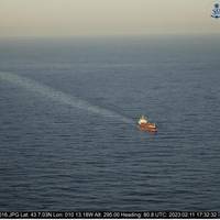
Spain has detained and fined a Maltese-flagged oil tanker it says discharged oil in open waters near the northeastern port city of Tarragona, a transport ministry department said.Spain's Mediterranean and Atlantic coastlines have become hubs for shipping activity including the transfer of oil known as ship-to-ship (STS) operations, which industry sources say are becoming an increasing safety concern.Spanish authorities said they had intercepted the Lagertha after a discharge of hydrocarbons was detected by aircraft sensors and satellite radar on Feb.
What Does Climate Change Mean for Extreme Waves?
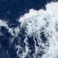
In 80% of the world, we don’t really know.Across much of the world’s oceans, waves are getting bigger. In the Southern Ocean, where storm-driven swell can propagate halfway across the world to California, the average wave has grown about 20cm in the past 30 years.These changes are part of climate change, and are likely to continue well into the future. If you’re making long-term plans near the sea – like building ships, or constructing flood defenses in coastal cities – you need more detail about how big those waves are going to get.In a study published this week in Science Advances…
AI & Machine Learning, Possible Force Multipliers for the Coast Guard

Artificial intelligence (AI) and machine learning (ML): mention these two terms and the listener may instantly think of the ads displayed as you view your favorite online news site. This is one version of what AI/ML might be. Given the state of AI and ML research today, these advanced mathematical techniques represent something the U.S. Coast Guard should explore for mission application. To do this, common definitions need to be created, challenges understood, and practical use…
New Satellite Technology Boosts Glacier Research
Bremerhaven, November 4, 2016. Scientists from the Alfred Wegener Institute are developing with experts from the German Aerospace Centre (DLR) a new satellite measurement method for the observation from space of the large ice masses of Greenland and the Antarctic. "Tandem L" is the name of a new satellite radar system, Which launched in the year 2022 Could Provide urgently needed data Concerning the shrinkage of the ice sheets in Both hemispheres. Concerning the construction of the radar and the launch of the satellite mission of the same name, the Science Council is to advise the Federal Ministry of Education and Research (BMBF) at the end of November as part of a review procedure.
Scientists Say Antarctic Glaciers in 'Irreversible' Thaw
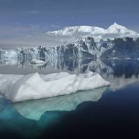
Vast glaciers in West Antarctica seem to be locked in an irreversible thaw linked to global warming that may push up sea levels for centuries, scientists said on Monday. Six glaciers, eaten away from below by a warming of sea waters around the frozen continent, were flowing fast into the Amundsen Sea, according to the report based partly on satellite radar measurements from 1992 to 2011. Evidence shows "a large sector of the West Antarctic ice sheet has gone into a state of irreversible retreat"…
Satellite Radar
With the ocean moving more than 90% of world commerce, keeping it secure is of vital importance – yet our ability to monitor activity at sea is somewhat more challenging than on land given the vastness of the oceans. Also many maritime monitoring systems rely on ships to ‘opt-in’, that can leave potentially risky blind spots in our picture of maritime traffic. This article, derived from a presentation that David Beard of the Defence Science and Technology Laboratory gave at the recent DMC and NovaSAR International Conference…
Keeping European Shipping on the Straight & Narrow
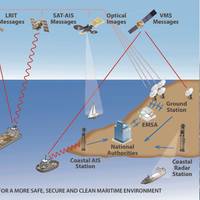
The European Maritime Safety Agency (EMSA) explains its role in support of marine safety, pollution, maritime security & vessel monitoring in a new brochure. EMSA operates maritime information systems to support the maritime monitoring activities of the Commission and Member States. • detect oil pollution and vessels through satellite images. EMSA operates the European oil spill and vessel detection service CleanSeaNet. This service analyses satellite radar images to detect possible oil spills on the sea surface. Oil spills appear as dark shapes on the image.


