

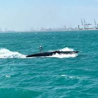
Protecting Offshore Energy Sources via USV
When most people discuss energy sources such as fossil fuel and green energy, it is from an “either-or” perspective. Some favor the former while others advocate for the latter. However, what is often lost in the arguments on both sides is that regardless of the type of energy being extracted or generated, those platforms that are offshore, especially oil rigs, oil and gas pipelines, and wind farms, are incredibly vulnerable to anyone who wants to attack these sources in wartime…
James Fisher Subsea Excavation Completes Project in Taiwan
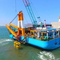
Global subsea excavation specialist James Fisher Subsea Excavation (JFSE), a part of James Fisher and Sons plc, said it has completed its first project in Taiwan. Experts from the mass/controlled flow excavation (M/CFE) provider deployed the shallow draft Twin R2000 tool to de-bury and retrench a cable for maintenance as part of the prominent Formosa 1 wind farm development for its client, cable lay contractor Woen Jinn Harbor (WJH). The Twin R2000’s non-contact method and ability…
Industry Award for Simrad Structurescan 3D Sonar
Simrad StructureScan 3D sonar imaging has won the National Marine Manufacturers Association (NMMA) Innovation Award in the Consumer Electronics category at the 2016 Miami International Boat Show. Following the success of the Simrad NSO evo2 multifunction display in 2014, and Simrad ForwardScan sonar in 2015, this is the third consecutive NMMA innovation win at the Miami show for the brand. Simrad HALO Pulse Compression Radar also won the NMMA Innovation Award in September at the 2015 International Boat Builders’ Exhibition and Conference (IBEX). The Innovation Awards program, organized by the NMMA and judged by Boating Writers International (BWI)…
Lowrance Debuts Elite Ti Series Fishfinder/Chartplotters
Lowrance, a world-leading brand in fishing electronics since 1957, announced today the release of a new, premium Elite Ti standalone series of fishfinder/chartplotters. The Lowrance Elite-5 and Elite-7 Ti touchscreen fishfinder/chartplotters offer anglers high-performance at an incredible value. With an easy-to-use touchscreen interface, Bluetooth and wireless connectivity, proven Lowrance navigation technology and high-performance sonar – including CHIRP sonar, StructureScan HD and DownScan Imaging – the Elite Ti Series is a robust, feature-rich, yet compact solution – all at an affordable price. The Lowrance Elite Ti is designed for anglers who want a complete view of the area beneath their boat.
Lowrance Debuts StructureScan 3D
Lowrance, a world-leading brand in fishing electronics since 1957, announced today the release of a game-changing,sonar-imaging system – Lowrance StructureScan 3D. Lowrance StructureScan 3D allows anglers to easily see fish, underwater structure and bottom contours in a stunning three-dimensional display on their HDS Gen3fishfinder/chartplotter. StructureScan 3D imaging quickly scans underwater terrain and fish-holding structure to createhigh-resolution, 180-degree super-wide, three-dimensional views – in depths to 300 feet and as far as 600 feet port and starboard. Yielding captivating images withunprecedenteddetail, StructureScan 3D…
Arctic Wreck Found after 169 Years
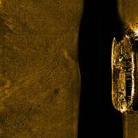
After more than 169 years, Canadian researchers discovered one of the two ships from the doomed Arctic expedition of Sir John Franklin, cracking one of the largest mysteries in sea exploration. The wreck was found some 11 meters below the surface using a ROV recently acquired by Parks Canada. It is unknown whether the ship is HMS Erebus or HMS Terror, though researches expect to determine its identity within several days. "Franklin's ships are an important part of Canadian history given that his expedition…
Wave & Tide Measurement: Falmouth Scientific Unveil New Products
Falmouth Scientific, Inc. (FSI) announce two new additions to their PLUS FAMILY of measurement instruments: the ACM-WAVE-PLUS and WAVE-TIDE-PLUS, which join the ACM-PLUS acoustic current meter that they say has set a new standard for cost-effective single-point current measurement. The new ACM-WAVE-PLUS provides current speed & direction, wave direction, wave height, and other wave statistics by combining FSI’s enhanced ACM-PLUS technology with a high- accuracy, micro-machined silicon pressure sensor, while the WAVE-TIDE-PLUS provides an economical solution for applications that only need non-directional wave height and tide characteristics.
Sonardyne to Demo Research Vessel at Ocean Business 2013
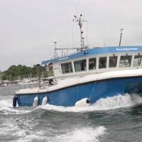
Daily demonstrations are the key focus of Sonardyne International Ltd.’s presence at this year’s Ocean Business in Southampton. Taking place at the National Oceanography Centre (NOC) from Tuesday 9th April to Thursday 11th April, Sonardyne’s trials and research vessel, Sound Surveyor, boasts a packed program schedule including Sprint INS, 6G multi-user acoustics and Solstice Side Scan Sonar. Inside on Sonardyne’s stand, E1, visitors will be able to explore technology for acoustic positioning, inertial navigation, sonar imaging and wireless communications.
Kraken Awarded AquaPix Sonar Contract
Kraken Sonar Systems Inc., a marine technology company, has announced that it has been awarded a contract for an AquaPix Interferometric Synthetic Aperture Sonar system by Australia’s Defence Science and Technology Organization (DSTO). DSTO is the Australian government’s lead agency charged with applying science and technology to protect and defend Australia and its national interests. DSTO delivers expert, impartial advice and innovative defence solutions to agencies such as the Royal Australian Navy. Kraken’s AquaPix Interferometric Synthetic Aperture Sonar (InSAS) system provides seabed images with unprecedented image resolution and detail.
Marine Electronics – Sonar 3D Imaging Resolution Improved
Northstar Electronics, Inc. which previously signed a Letter of Intent to acquire Echotec Sonar, is announcing improvements in Echotec's sonar image quality. Echotec Sonar, through new techniques in sonar engineering, has recently made breakthroughs which have improved sonar image resolution levels by a measurable amount. The company has found a way to bring quality to a level where it is significantly better than the diffraction limit would normally allow. These performance gains are a direct result of the use of high bandwidth technology in a new and unique way. To the operators of the sonar equipment, this yields a much crisper image than they have experienced in the past with standard equipment.
Simrad Yachting Receives NMEA Awards
Simrad Yachting, a leader in the design and manufacture of world-class marine navigation, autopilot, radar, communications and fishfinding systems, announced that its innovative NSE multifunction display and professional-grade autopilot systems received multiple awards at the 2010 National Marine Electronics Association (NMEA) convention held in Seattle, Wash. Judged by a panel of experts organized by Boating Writers International (BWI), Simrad NSE with 2.0 software functionality received “Honorable Mention” in the event’s most prestigious category, the “NMEA Technology Award.” Continuing a long-standing tradition as an industry favorite, the Simrad AP24 and AP28 also received top honors for “Best Autopilot” as voted by NMEA members.
Bow Mariner Update: Oil Recovery Ops Continue
According to the Coast Guard, the Marine Spill Response Corporation (MSRC) oil recovery vessel VIRGINIA RESPONDER began skimming operations, however, recoverable oil is widely dispersed and the amount recovered has been minimal to date. A helicopter has been flying throughout the day to locate patches of oil and direct the skimming vessel. The oil spill recovery vessel has been on-scene since Monday prepared to recover oil. Previous flights of the area located oil that was too spotty, patchy and widely dispersed to efficiently pick-up. On-scene conditions are favorable. During a Tuesday over flight, patches of oil were located in the area where the T/V BOW MARINER sank Saturday night.


