

Storm Brewing in Gulf of Mexico Set to Strengthen
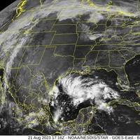
A storm system brewing in the Gulf of Mexico could strengthen into a named storm as it takes aim at the Texas coast, the U.S. National Hurricane Center said on Monday.The system, named Potential Tropical Cyclone 9, was about 480 miles (770 km) east-southeast of Port Mansfield, Texas and was packing maximum sustained winds of 30 miles (45 km) per hour, the Miami-based hurricane center said. It could cause coastal flooding along the south Texas coast between Monday night and Tuesday…
Oil Jumps on Weather Concerns in Gulf of Mexico

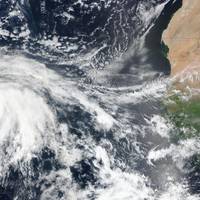
Oil prices jumped 2% on Friday after three days of losses, driven higher as a storm formed in the Gulf of Mexico, but were on track for a weekly fall as investors braced for the return of Iranian crude supplies after officials said Iran and world powers made progress a nuclear deal.Brent crude futures rose $1.33, or 2%, to $66.36 a barrel by 1:06 p.m. ET (1606 GMT), while U.S. West Texas Intermediate was at $63.54 a barrel, up $1.61, or 2.6%.A weather system forming over the western Gulf of Mexico has a 40% chance of becoming a cyclone in the next 48 hours, the U.S.
US Offshore Evacuations Begin as Record-breaking Storm Threatens
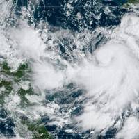
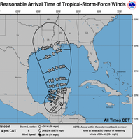
Energy companies on Monday began evacuating offshore oil platforms as the 25th named storm of the year formed in the Caribbean and was forecast to become a major hurricane before it entered the Gulf of Mexico and threatens the U.S. mainland.Tropical Storm Delta was expected to rapidly strengthen and become a Category 3 hurricane with up to 120 mile per hour (194 kilometers per hour) winds. It was about 160 miles south southwest of Negril, Jamaica, on Monday evening and moving west at 8 mph.Delta will bring rain…
Offshore Oil Wells, Ports Shut as Hurricane Sally Advances on U.S. Gulf
Energy companies, ports and refiners raced on Monday to shut down as Hurricane Sally grew stronger while lumbering toward the central U.S. Gulf Coast, the second significant hurricane to shutter oil and gas activity over the last month.The hurricane is disrupting oil imports and exports as the nation's sole offshore terminal, the Louisiana Offshore Oil Port (LOOP), stopped loading tanker ships on Sunday, while the port of New Orleans closed on Monday.The U.S. government said 21%…
U.S. Gulf of Mexico Oil Firms Resuming Output as Storm Passes

Energy companies on Monday began preparations to resume oil and gas production in the U.S. Gulf of Mexico, a day after Tropical Storm Cristobal blew through with high winds and heavy rains.Producers had evacuated 182 offshore facilities and shut in about a third of oil and gas production in U.S. Gulf of Mexico wells as of Monday.Royal Dutch Shell Plc, Murphy Oil Corp and BP Plc were among the companies that said on Monday they were starting to resume normal operations and return…
Oil Producers Evacuating GoM Workers Ahead of Storm
BP Plc began turning off production at three platforms in the northern Gulf of Mexico and evacuating workers because of the threat from Tropical Storm Cristobal, forecast to make landfall in Louisiana over the weekend, the company said.Norwegian state-oil company Equinor ASA began evacuating non-essential workers on Wednesday and plans to shut production on Friday at its Titan oil platform if the storm continues along its projected path, spokesman Hasting Stewart said.Occidental Petroleum Corp also began flying non-essential workers to shore from central Gulf of Mexico operations…
Offshore Vessel Sinks: 3 Rescued, 1 Dead, 10 Missing

French offshore vessels owner Bourbon confirmed that its tug supply vessel Bourbon Rhode sank in middle of the Atlantic Ocean while navigating heavy seas near a category 4 hurricane on Thursday. Three crew members have been rescued, the body of one deceased has been recovered, and responders are searching for 10 crew still missing.The body of one crew member was located by an aircraft and recovered by a vessel in the search area, Bourbon said on Monday. The seafarer's family has…
Bourbon Vessel Taking on Water Near Hurricane Lorenzo
Bourbon said a mission has been launched to rescue 14 crew from one of its vessels taking on water in heavy seas near a category 4 hurricane in the Atlantic Ocean.The French offshore vessels owner said water is entering the stern of the 49.5-meter tug supply vessel Bourbon Rhode, about 60 nautical miles south-southeast from the eye of hurricane Lorenzo.The US National Hurricane Center said on Thursday morning the category 4 storm is packing maximum sustained winds of 130 miles per hour and moving west-northwest at 13 miles per hour.As of Thursday afternoon…
Bahamians Struggle in Dorian's Devastating Wake

Stunned residents of the Bahamas surveyed the wreckage of their homes and officials struggled to assess the number killed by Hurricane Dorian, as the storm bore down on the South Carolina coast, threatening record flooding on Thursday.The United Nations said 70,000 people in the Bahamas needed immediate humanitarian relief after the most damaging storm ever to hit the island nation.Aerial video of the worst-hit Abaco Islands in the northern Bahamas showed widespread devastation…
NHC: Dorian weakens to Category 2 Hurricane

Dorian weakened on Tuesday but was heading north-westward and growing in size, moving "dangerously close" to the Florida east coast late Tuesday through Wednesday evening, the U.S. National Hurricane Center (NHC) said.Dorian, now a Category 2 storm on the five-step Saffir-Simpson Wind Scale, is located about 105 miles (170 kilometers) east of Fort Pierce, Florida, with maximum sustained winds of 110 miles per hour (175 km per hour).Separately, and from Portsmouth, VA, the Captain of the Port set Port Condition X-ray for the Port of Virginia at 9 a.m.
Duke Energy to Shut N.C. Brunswick Nuclear Plant Ahead of Florence
Duke Energy Corp started to shut the Brunswick nuclear power plant in North Carolina ahead of Hurricane Florence, which is expected to strike the coast near the plant on Friday.Florence is currently a Category 2 storm with maximum sustained winds of 110 miles per hour (177 kph), according to the U.S. National Hurricane Center (NHC). On its current track, the storm will hit the coast on Friday with maximum sustained winds of about 105 mph.Duke spokeswoman Mary Kathryn Green said the company was following its procedures and is shutting Unit 1 now and would start shutting Unit 2 at the 1,870-megawatt plant later today. One megawatt can power about 1,000 U.S.
Hurricane Florence Barrels in on US East Coast
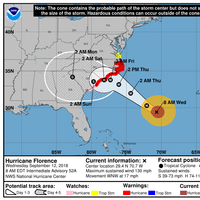
Hurricane Florence is forecast to be a major hurricane when it nears the U.S. coast on Thursday, bringing life-threatening storm surge and rainfall to portions of the Carolinas and Mid-Atlantic states, the U.S. National Hurricane Center (NHC) said in an advisory on Wednesday morning.The extremely dangerous hurricane, currently a category 4, is located about 530 miles southeast of Cape Fear, N.C. packing maximum sustained winds of 130 miles per hour, it said in an advisory issued…
Tropical Depression 17 Forms over Eastern Atlantic: NHC
Tropical Depression 17 has formed over the Eastern Atlantic and is expected to strengthen into a tropical storm later on Monday, the U.S. National Hurricane Center (NHC) said. The system is about 875 miles (1,405 km) west-southwest of the Azores with maximum sustained winds of 35 miles per hour (55 km/h), the NHC said. Reporting by Vijaykumar Vedala
U.S. Insured Losses from Hurricane Nate around $500 mln
Insured losses in the United States from Hurricane Nate will be close to $500 million, catastrophe modelling company Karen Clark & Company (KCC) said on Monday. The U.S. National Hurricane Center (NHC) said on Monday that the former hurricane has become a post-tropical cyclone that continues to pack heavy rain and gusty winds. Hurricane Nate caused flooding in Mississippi, but spared the state from catastrophic damages. On Monday, it was expected to continue tracking northeastward, moving through the Ohio Valley and into the lower great lakes. KCC said the estimates included insured wind and storm surge losses to residential, commercial, and industrial properties and autos.
Nate Becomes a Post-Tropical Cyclone: NHC
Former hurricane Nate has become a post-tropical cyclone that continues to pack heavy rain and gusty winds, the U.S. National Hurricane Center (NHC) said on Monday. The storm system is about 85 miles (135 km) northeast of Columbus, Ohio with maximum sustained winds of 20 mph (55 km/h), it said. Nate was expected to continue tracking northeastward, moving through the Ohio Valley and into the lower great lakes on Monday. Reporting by Vijaykumar Vedala
Weakened Maria Could Regain Major Hurricane Status -NHC

Maria, which weakened into a Category 2 hurricane on Wednesday, could regain major hurricane status by Thursday, the U.S. National Hurricane Center (NHC) said in its latest advisory. Catastrophic flash flooding was occurring over portions of Puerto Rico with conditions now deteriorating over the eastern Dominican Republic, the NHC said. The hurricane was about 25 miles (45 km) north northwest of Aguadilla, Puerto Rico with maximum sustained winds of 110 miles per hour (175 km per hour), the Miami-based NHC said. Any hurricane with top sustained winds of at least 111 is classified as major.
Hurricane Maria Regains Category 5 Strength
Hurricane Maria has intensified and regained its Category 5 hurricane strength, the U.S. National Hurricane Center (NHC) said on Tuesday. Maria, which made landfall in Dominica as a Category 5 storm on Monday night, is about 205 miles (325 km) southeast of St. Croix with maximum sustained winds of 160 mph (260 km/h), it said. The hurricane is expected to move towards the Virgin Islands and Puerto Rico on Tuesday night and Wednesday, the Miami-based weather forecaster added. Reporting by Vijaykumar Vedala
Maria Seen Strengthening into Major Hurricane
A second powerful storm in as many weeks was bearing down on a string of battered Caribbean islands, with forecasters saying Maria would strengthen rapidly into a major hurricane as it ripped into the Leeward Islands on Monday night. Maria's strength was building as it approached the Lesser Antilles, the U.S. National Hurricane Center said, estimating its winds near 90 miles per hour (145 kph). "Maria is expected to become a major hurricane as it moves through the Leeward Islands," the forecaster said, marked by "rapid strengthening" during the next 48 hours. Maria is approaching the eastern Caribbean less than two weeks after Irma hammered the region before overrunning Florida.
Irma to Weaken by Tuesday Afternoon: NHC
Hurricane Irma was losing strength as its center moved toward the northwestern coast of the Florida Peninsula on Monday and was forecast to weaken to a tropical storm during the day and to a tropical depression by Tuesday afternoon, the U.S. National Hurricane Center (NHC) said. Irma, once ranked as one of the most powerful hurricanes recorded in the Atlantic, was about 60 miles (100 km) north of Tampa, Florida, carrying maximum sustained winds of 75 miles per hour (120 km per hour), the center said in a 5 a.m. ET (0900 GMT) advisory. Irma's center would cross the eastern Florida Panhandle into southern Georgia on Monday afternoon, then move through southwestern Georgia and eastern Alabama on Monday evening and Tuesday, the NHC forecast. Reporting by Vijaykumar Vedala
Irma Churns Through Caribbean, Possibly Enroute to Florida
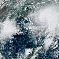
Hurricane Irma, one of the most powerful Atlantic storms in a century, churned across northern Caribbean islands on Wednesday with a potentially catastrophic mix of fierce winds, surf and rain, en route to a possible Florida landfall at the weekend. Irma is expected to become the second powerful storm to thrash the U.S. mainland in as many weeks but its precise trajectory remained uncertain. Hurricane Harvey killed more than 60 people and caused damaged estimated as high as $180 billion when it hit Texas late last month. The eye of Irma, a Category 5 storm packing winds of 185 miles per hour (295 km per hour), moved away from the island of Barbuda and toward the island of St. Martin, east of Puerto Rico, early on Wednesday, the U.S. National Hurricane Center (NHC) in Miami reported.
Irma Strengthens to a Category 5 Hurricane
Irma on Tuesday intensified into an extremely dangerous Category 5 hurricane on the Saffir-Simpson wind scale, the U.S. National Hurricane Center (NHC) said in its latest advisory. Hurricane Irma is about 270 miles (440 km) east of Antigua and packing maximum sustained winds of 175 mph (280 km/h), the Miami-based weather forecaster said. Irma, which is forecast to remain a powerful category 4 or 5 hurricane during the next couple of days, will move near or over portions of the northern Leeward Islands Tuesday night and early Wednesday, the NHC said. Reporting by Swati Verma
Irma Barrels Toward Caribbean, U.S. Mainland
Hurricane Irma, a powerful Category 4 storm, plowed toward the Caribbean and the southern United States on Tuesday as islands in its path braced for possible life-threatening winds, storm surges and flooding. Hurricane warnings and watches were in effect for parts of the Leeward Islands, the British and U.S. Virgin Islands and Puerto Rico, in preparation for a storm that was intensifying with 150 mph (240 kph) winds, the U.S. National Hurricane Center (NHC) said. "Dangerous Hurricane Irma heading for the Leeward Islands," the hurricane center said. A Category 4 hurricane on the five-step Saffir-Simpson scale means sustained winds of 130-156 mph (209-251 kph) with "catastrophic" outcomes.
Harvey Likely to Linger off Texas Coast
The center of Tropical Storm Harvey is likely to remain just off the coast of Texas through Tuesday night before moving inland over the northwestern Gulf of Mexico on Wednesday, the U.S. National Hurricane Center (NHC) said. The storm is not expected to further intensify before its center crosses the coast again within 36 hours or so, the NHC said. Harvey is now located about 135 miles (220 km) south-southwest of Port Arthur, Texas with maximum sustained winds of 45 miles per hour (75 km per hour), it added. Reporting by Arpan Varghese


