Teledyne Marine
Teledyne Marine News
Teledyne Acquires ChartWorld International

Teledyne Technologies Incorporated announced today that it has acquired ChartWorld International Limited and affiliates. ChartWorld, headquartered in Cyprus, with additional locations in Hamburg, Singapore, Vancouver and Tokyo, is a provider of digital marine navigation hardware and software provided through a subscription-based model. Terms of the transactions were not disclosed.Commercial maritime…
Racing to the Bottom: Seabed Warfare Brings Threats, Opportunities
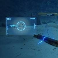
In the early morning hours of September 26, 2022, seismologists located throughout northern Europe detected two disturbances originating in the Baltic Sea that were consistent with underwater explosions. Within hours, an aerial image captured by a passing Danish F-16 showed an expanse of frothy seawater, suggesting that the Nord Stream 1 and Nord Stream 2 gas pipelines had experienced a catastrophic event.
Teledyne Acquires FLIR

Industrial conglomerate Teledyne Technologies Incorporated (NYSE:TDY) said it has completed its acquisition of thermal imaging cameras and sensors company FLIR Systems, Inc. (NASDAQ:FLIR). FLIR will now be included in Teledyne’s Digital Imaging segment and operate under the name Teledyne FLIR.Under the terms of the cash-and-stock deal announced in January, FLIR stockholders received $28.00 per share in cash and 0.0718 shares of Teledyne common stock for each FLIR share…
Ship Repair: Inside the $60m Refit of RV Roger Revelle
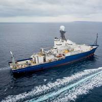
This month MR dives inside the $60 million refit of RV Roger Revelle, a project which leverages a treasure trove of ‘lessons learned’ from recent refits in the academic research vessel fleet and highlights the value of slimming the vendor list.Research vessel (R/V) Roger Revelle is back at work after a midlife refit involving upgrades from top to bottom, bow to stern. The ship is owned by the Office…
Surveyors Map Sunken Liberty Ship off Texas Coast
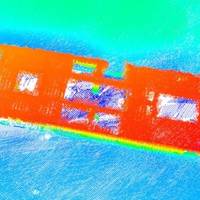
U.S.-based marine data acquisition services company TDI-Brooks said it recently mapped the Liberty Ship George Vancouver off Freeport, Texas while out on a seabed survey project with the R/V Brooks McCall. The multiple multi-phase geophysical and geotechnical site surveys program consisted of pipeline routing and subsea structures to facilitate route and project design for offshore developers.Equipment…
Measuring the Hostile Ocean Beneath Hurricanes
Unmanned Vehicles Collect Data for Improving Storm ForecastsThe influences of ocean conditions and currents on living environments are now more widely appreciated—from the Earth’s climate and severe weather conditions to fisheries and biodiversity. Sustained and widespread measurements are needed to provide essential clues for understanding the oceans, for effective monitoring of environmental changes…