NOAA's Thomas Jefferson Conducting Surveys

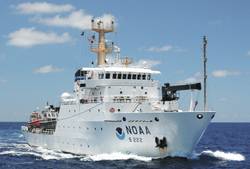
NOAA Ship Thomas Jefferson conducts sea floor surveys to keep shipping safe along Long Island coast.
NOAA Ship Thomas Jefferson continues today on a three-month survey of the sea floor off the coast of New York, Connecticut and Rhode Island, as part of a multi-year effort to update nautical charts for Block Island Sound and keep large ships and commerce moving safely.
In addition to supporting marine navigation, data acquired by the 208-foot hydrographic survey vessel will also support a seafloor mapping initiative by Connecticut and New York.
"With bigger ships, crowded sea lanes, and more uses of ocean areas, shipping today is increasingly a task of precision and accuracy,” explained NOAA Corps Cmdr. Lawrence Krepp, commanding officer of Thomas Jefferson and the ship’s chief scientist. “This area is seeing an increase in the numbers of deep draft vessels requiring depths of more than 60 feet, and the pilots need precise and up-to-date depth measurements as they navigate. Our task is to measure the ocean depths, search for dangers to navigation, and give mariners the information they need to protect lives and the environment, while also increasing shipping efficiencies.”
Equipped with the latest scientific instrumentation for checking channel seafloors for shoaling and debris, Thomas Jefferson is also an emergency responder providing data needed for reopening ports after hurricanes. The ship was in place and prepared to help speed the resumption of maritime commerce after Hurricane Irene blew through the Port of New York & New Jersey last weekend, and she will be recalled from her normal surveying operations if needed to help with emergency surveys for any future storms.
The survey project is managed by NOAA’s Office of Coast Survey, which produces and maintains the nation’s suite of nautical charts. Coast Survey first charted the New York area in the mid-1800s, after President Thomas Jefferson tasked the agency with creating maps of the coastal waters so that the young nation’s shipping industry could thrive. Today’s data is increasingly valuable for other applications as well.
“Ocean floors are amazingly dynamic, and we have to chart those changes. Our data is used to update NOAA’s nautical charts, but the hydrographic information can also be used to support a number of non-traditional uses, ranging from benefits to fisheries management to support of regional ocean planning efforts,” Krepp said.
NOAA’s survey effort of the area began in 2009, when Thomas Jefferson surveyed 174 square nautical miles in Block Island Sound. This year’s effort, from August through November, will survey 228 square nautical miles. Cmdr. Krepp gained his hydrographic experience through 18 years in the NOAA Corps, on land and on sea. He served on board the NOAA Ship Whiting when it conducted search and recovery missions for John F. Kennedy Jr.’s Piper Saratoga plane off the coast of Martha’s Vineyard and the Egypt Air 990 crash off the coast of Nantucket. At both of these tragedies in 1999, Whiting searched the ocean floor for aircraft wreckage.
Commissioned in 2003, Thomas Jefferson is one of three ships in the NOAA fleet that conduct hydrographic surveys in support of the nautical charting mission of NOAA’s Office of Coast Survey. In addition to supporting routine hydrographic survey missions, the ship provides scientific response to emergencies, such as last summer’s Deepwater Horizon oil spill, and emergency navigation response surveys to hurricanes Katrina and Rita in 2005.
Thomas Jefferson’s crew of 31 is comprised of NOAA Corps Officers, licensed and unlicensed civilian wage mariners. The ship primarily operates along the Atlantic and Gulf coasts, including Puerto Rico and the U.S. Virgin Islands.Homeported in Norfolk, Va., Thomas Jefferson is part of the NOAA fleet of ships and aircraft operated, managed and maintained by NOAA's Office of Marine and Aviation Operations, which includes both civilians and the commissioned officers of the NOAA Corps, one of the seven uniformed services of the United States.
NOAA’s Office of Coast Survey, originally formed by President Thomas Jefferson in 1807, updates the nation’s nautical charts, surveys the coastal seafloor, responds to maritime emergencies and searches for underwater obstructions and wreckage that pose a danger to navigation.
NOAA’s mission is to understand and predict changes in the Earth's environment, from the depths of the ocean to the surface of the sun, and to conserve and manage our coastal and marine resources. Join us on Facebook, Twitter and our other social media channels.
On the Web:
NOAA Office of Marine and Aviation Operations: http://www.omao.noaa.gov
NOAA Office of Coast Survey: http://www.nauticalcharts.noaa.gov