Vice Adm. Brown Confirmed as NOAA Deputy Administrator
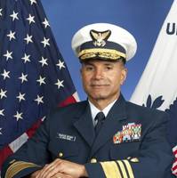
Retired Coast Guard Vice Adm. Manson Brown was appointed by President Obama and confirmed by a voice vote of the U.S. Senate to serve as assistant secretary of commerce for environmental observation and prediction and deputy administrator for NOAA. Brown joins NOAA after 36 years of service in the U.S. Coast Guard. As deputy administrator, Brown will play a major role driving the Obama administration and NOAA priorities for weather and water services, climate science, plus the agency’s integrated mapping and Earth-observing capabilities.
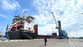
Jacksonville Adds PORTS Real-time Data System
Officials from NOAA, the Jacksonville Marine Transportation Exchange, and the Jacksonville Port Authority officially dedicated a new information system today which will increase safety for ships using the St. Johns River. The system, called Physical Oceanographic Real-Time System (PORTS), provides real-time information on water levels, currents, meteorological conditions, and under-bridge clearance, giving users critical information when traveling through the river. The St. Johns River in Jacksonville will become the 23rd location to use the system and is the second largest PORTS ever established. “Our nation’s ports are critical cogs in our country’s economic engine,” said Kathryn D. Sullivan, Ph.D., under secretary of commerce for oceans and atmosphere and NOAA administrator.
NOAA: New AK Chart Makes Arctic Safer
NOAA: New Alaska navigational chart makes increased Arctic shipping safer; Kotzebue Harbor chart replaces measurements last taken in 19th century. NOAA formally presented today to Alaska officials a new nautical chart for Kotzebue Sound in the Alaskan Arctic, a sparsely charted region that is seeing increased vessel traffic because of the significant loss of summer sea ice. The new chart depicts the full range of depth measurements and object detection acquired during a full ocean bottom survey last summer by the NOAA hydrographic survey ship Fairweather.