Maritime Autonomy Operational Seminar Launched
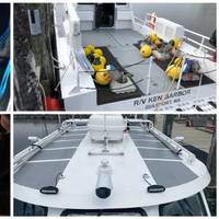
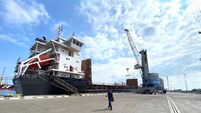
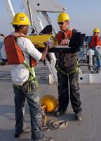
A new seminar is the first maritime autonomy training program to allow the federal workforce to train on state-of-the-art, commercial, off-the-shelf autonomous technologies.Sea Machines Robotics’ in partnership with The University of Southern Mississippi (USM) Roger F. Wicker Center for Ocean Enterprise in Gulfport, Miss. has developed the Maritime Autonomy Operational Seminar through USM's Center of Higher Learning at the John C. Stennis Space Center.Participants plan missions that transform USM's R/V Ken Barbor…
Opinion: A Call for the USNS Walter Munk to Honor America’s Greatest Oceanographer
In the 2021 National Defense Authorization Act, Congress established a commission to rename several military bases and ships that commemorate members of the Confederacy. One of these is the Naval oceanographic ship USNS Maury (T-AGS 66), named after oceanographer Matthew Fontaine Maury, who resigned his commission in the U.S. Navy to join the Confederacy at the outbreak of the American Civil War. The USNS Maury is an asset of the Naval Meteorology and Oceanography Command (NMOC), which I led from 2014-2017.
Marine Biofouling in Ports: Wet Docks Acting as ‘Hot Spot’ Biofouling Transfer Stations
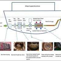
The GEF-UNDP-IMO Glofouling partnership (2017) is a global initiative to counter the environmental issue of invasive aquatic species (IAS) and the resulting harmful ecological and financial damage that can occur when such invasion events are introduced through the medium of biofouling on ships hulls and other marine structures such as those found in the oil and gas industries.One of the key objectives of the Glofouling project is to develop a Global Knowledge Hub and also identify…
Halter Marine Awarded Contract for T-AGS 67
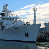
Pascagoula, Miss. shipbuilder Halter Marine has been awarded a $149,053,160 fixed-price-incentive (firm target) modification to definitize contract number N00024-19-C-2208 for the detail design and construction of one oceanographic survey ship (T-AGS 67), the U.S. Department of Defense announced on Friday.The shipyard has delivered the seven previous survey ships in the Pathfinder-class, the first of which, USNS Pathfinder (T-AGS-60), entered service in 1994. Today, six of the ships are still operational, including the newest ship, USNS Maury (T-AGS-66), commissioned in 2016.Owned by the U.S.
Subsea Defense: Navy Deepens Commitment to Underwater Vehicles
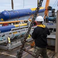
The U.S. Navy uses unmanned and robotic underwater vehicles for a multitude of functions, including environmental sensing, mine hunting, and salvage. The Navy plans to evolve an unmanned systems operating concept that is platform agnostic and capable of operating in highly complex contested environments with minimal operator interaction.The most recent edition of the Navy’s Unmanned Systems (UxS) Roadmap was issued in 2018, and a new version is expected in the near future. The 2018 document states that UxS will operate in every domain…
Interview: Rear Admiral John Okon, Commander, Naval Meteorology and Oceanography Command, US Navy
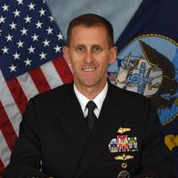
Insights on technology advances with Rear Admiral John Okon, Commander, Naval Meteorology and Oceanography Command.Rear Admiral Okon never started out to have a career in Oceanography, rather in Broadcast Meteorology. “At NY Maritime College, I studied both Meteorology and Oceanography and became equally passionate about Oceanography. Thanks to the U.S. Navy, we have a career field in both.”By its very nature, the U.S. Navy operates in one of the most discussed and disected environments on earth, the oceans.“The ocean is critical to National and Global Security.
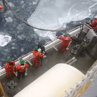
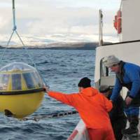
US Navy Buoys into the Arctic Ocean
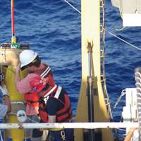
The U.S National Ice Center (USNIC) in coordination with the Office of Naval Research, Office of the Oceanographer of the Navy, the Danish Joint Arctic Command, Environmental and Climate Change Canada and University of Washington deployed buoys into the Arctic Ocean during a joint mission. The joint mission was conducted to collect weather and oceanographic data to enhance forecasting and environmental models thereby reducing operational risk for assets in the Arctic. "Polar lows are like hurricanes of the north and the data collected from these buoys will help us with numerical weather prediction, which will help to keep our and our partner forces safe," said Cmdr. Ruth Lane, Commanding Officer, U.S. National Ice Center.
Obituary: Stewart B. Nelson
Stewart B. Nelson, Ph.D. - B. June 9, 1937 D. Dr. Stewart B. Nelson URI -MMA 1974, oceanographer, explorer, author, lecturer and marine historian passed away of complications related to cancer on September 12, 2016 in Tampa, Fla. He is mourned by family, friends and classmates of the Marine Affairs Program at the University of Rhode Island. Dr. Nelson's multifaceted career was principally spent in service to his country in his position as aide to the Office of the Oceanographer of the Navy and in this capacity he was the Senior Advisor to the to the Oceanographer, a Rear Admiral Flag position. Dr. Nelson who later earned a Ph.D, from the University of Southern California, was a pivotal figure in the modern era of the Naval Oceanographic Office.
US Navy's New Oceanographic Vessel Sets Sail
The U.S. Navy's newest oceanographic survey vessel, USNS Maury (T-AGS 66), recently completed its maiden voyage from Pascagoula, Miss., where it was constructed at VT Halter Marine, to Port Everglades near Ft. Lauderdale, Fla. In Maury's first days at sea, the civilian survey detachment from the Naval Oceanographic Office (NAVOCEANO) aboard performed initial testing of routine over-the-side operations as well as testing equipment unique to the ship, including underwater cameras which will be used for autonomous underwater vehicle (AUV) launch and recovery in the future.
Oil Under Ice
The U.S. How did an urgent requirement to build a road to Alaska end up helping to design submarines and to recover oil spills in the Arctic ice? The Army Corps of Engineers was faced with a monumental challenge of building a highway to connect the “lower 48” to Alaska during World War II to keep America’s northernmost territory secure from invasion. The road crossed hundreds of miles of wilderness, and much of the roadbed sat up permafrost, presenting challenges to America’s roadbuilders.
Breakthrough Capability Keeps Subs, Ships Safe
Interactive software that can dramatically cut the time it takes to plan safe submarine missions is crossing over to the surface fleet and is being installed this month on the guided-missile cruiser USS Mobile Bay (CG 53), officials announced Dec. 16. Sponsored by the Office of Naval Research (ONR), the technology adds speed and precision the process of finding the best routes around hazards in waterways around the world. Sailors spend days or even weeks planning a successful navigation route for a mission. They collect maps and charts, analyze them, double check them and cross reference information that comes in various hard copy and digital forms.
Gallaudet Relieves Brown at Naval Meteorology and Oceanography Command

Rear Adm. Timothy C. Gallaudet relieved Rear Adm. Brian B. Brown as commander of the Naval Meteorology and Oceanography Command (NAVMETOCCOM) in a traditional change of command ceremony held June 18 at Stennis Space Center. Gallaudet was promoted to the rank of rear admiral (lower half) just prior to the ceremony. Brown said he felt “blessed and lucky” to have worked with the Navy’s military and civilian oceanography workforce to perform a mission so critical to the warfighting effectiveness and readiness of the fleet and joint force despite personal hardships…
Navy's Global Ocean Forecast System Goes Public
The U.S. Naval Research Laboratory (NRL) & the National Center for Environmental Prediction (NCEP) within the National Ocean and Atmospheric Administration (NOAA) have entered into a formal agreement that results in NCEP using Navy developed global ocean forecast model technology to make environmental ocean forecasts for public use. “Development of an advanced global ocean prediction system has been a long-term Navy interest,” said Dr. Gregg Jacobs, head, NRL Ocean Dynamics and Prediction Branch.
Latest DoD Navy Contracts
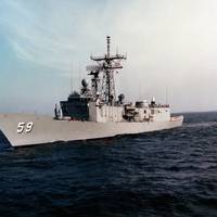
Amongst the latest contracts Department of Defense, Navy, contracts are those to Armstrong Marine, for barges and ship paintwork maintenance; to 3PSC for operation & maintenance of naval survey ships; and to NASSCO for repairs & alterations to 'USS Kauffman' (FFG 59). Armstrong Marine Inc., Port Angeles, Wash., is being awarded a $38,362,181 indefinite-delivery/indefinite-quantity, firm-fixed-price contract for the procurement of marine paint and maintenance barges and associated installation, support, shipping and travel.
Brown Relieves White at Naval Meteorology and Oceanography Command
Rear Adm.(lower half) Brian B. Brown relieved Rear Adm. Jonathan W. White as commander of the Naval Meteorology and Oceanography Command (NAVMETOCCOM) in a traditional Navy change of command ceremony on Aug. 3 at Stennis Space Center. "I am blessed to once again be part of the Navy's operational oceanography team and humbled to have been selected among so many talented officers to lead this command," Brown said to Naval Oceanography employees at the ceremony. For the past year, Brown has been the Executive Assistant to the Oceanographer and Navigator of the Navy in Washington, but he previously served at Stennis as commanding officer and executive officer of the Naval Oceanographic Office (NAVOCEANO) and on the NAVMETOCCOM staff. NAVOCEANO is NAVMETOCCOM's largest subordinate command.
MSC Deactivates USNS John McDonnell
Military Sealift Command oceanographic survey ship USNS John McDonnell was delivered to the Navy Inactive Ships Program in Pearl Harbor, Hawaii, for deactivation Aug. 25. Following the deactivation, MSC retains six Pathfinder-class oceanographic survey ships capable of surveying coastal regions and performing full ocean surveys. Construction of a new, more-capable survey ship, T-AGS 66, will start in October. McDonnell's deactivation comes as part of the effort to streamline survey operations. Unlike the Pathfinder class, which is capable of conducting both deep- and shallow-water scans, McDonnell was only equipped with the sensors to conduct shallow-water surveys.
NOAA, Navy Monitor Ocean Conditions Near Spill
NOAA Ship Thomas Jefferson is underway on a mission to deploy a variety of U.S. Navy ocean monitoring instruments in the vicinity of the BP Deepwater Horizon oil spill. The floats, drifters and autonomous underwater vehicles will aid researchers in monitoring the surface and deep currents that are distributing the oil. Of particular interest is the Loop Current and its potential to spread the oil to a much wider area. “NOAA is proud to partner with the U.S. Navy in the ongoing…
Naval Oceanographic Office to Get Major Supercomputer
The Naval Oceanographic Office (NAVO) Major Shared Resource Center (MSRC) will house a powerful new IBM supercomputer that will substantially increase its computational capacity. "This new IBM system represents a tremendous increase in the center's computational capacity," said Tom Dunn, director of the computer center. The Navy uses the supercomputer center both for operations and for research projects. Navy oceanographers run and analyze ocean models for a variety of Navy operations. Researchers use the supercomputer center for DoD-approved research projects. The new supercomputer, a Power 575 Hydro-Cluster, has a peak speed of 90 teraflops (90 trillion floating-point operations per second)…
USNS Pathfinder Participates in at-Sea Demonstration
Military Sealift Command oceanographic survey ship USNS Pathfinder arrived in , , to pick up Ukrainian personnel and members of the U.S.-based Institute for Exploration for an upcoming at-sea capabilities demonstration with ’s Department of Underwater Heritage. In April 2008, the Ukranian government invited the U.S. Navy’s 6th Fleet to demonstrate U.S. Navy hydrographic survey capabilities and to help search for SS Armenia, a sunken, World War II Soviet hospital ship. During the at-sea demonstration, civilian surveyors from the Naval Oceanographic Office Institute for Exploration and Ukraine’s Department of Underwater Heritage will work together to search for the downed vessel.
USNS Pathfinder Kicks off Capabilities Demonstration
Military Sealift Command oceanographic survey ship USNS Pathfinder kicked off its scheduled at-sea capabilities demonstration Sept. 7 after departing . During the at-sea demonstration, Pathfinder is searching for Soviet-flagged hospital ship SS Armenia which was sunk during World War II. Civilian surveyors from the U.S. Naval Oceanographic Office, Ukrainian sailors, surveyors and historians and a team of civilian oceanographers from the U.S.-based Institution for Exploration are conducting the search in Ukrainian territorial waters. Since the exact position of the wreckage is unknown, the Naval Oceanographic Office surveyors expect to use oceanographic tools such as a side-scan sonar and multi-beam sonar. This equipment uses sound pulses to locate possible shipwreck targets.
Pathfinder Identifies Sunken Vessels During At-Sea Demonstration
Military Sealift Command (MSC) oceanographic survey ship USNS Pathfinder (T-AGS 60) identified two sunken vessels during a joint, at-sea capabilities demonstration in Ukrainian territorial waters. German coastal submarine U-18 was the first target the oceanographers identified using underwater video capabilities with a remotely operated vehicle (ROV). The second ship is believed to be RUS Prut, a Russian minelayer that sank during World War I in 1914. "The sea floor is a resting place for brave sailors, regardless of the country they come from," said Dr. Serge A.
Titley New Oceanographer of the Navy
In a ceremony at the U.S. Naval Observatory, Rear Adm. David Titley assumed the office of oceanographer of the Navy, replacing retiring Rear Adm. David A. Gove. Titley will simultaneously maintain his current position as commander of the Naval Meteorology and Oceanography Command until a replacement can be found. Headquartered at the U.S. Naval Observatory, the oceanographer of the Navy serves as the advisor to the chief of naval operations for resources, requirements, and policy with regard to the Naval Oceanography Program. The program, which includes the disciplines of oceanography, hydrography, meteorology, geospatial information and services…
Raytheon Supports Naval Oceanographic Office
Raytheon Company (NYSE:RTN) has been awarded a task order to develop and support recertification of curricula through the Naval Education and Training Professional Development and Technology Center. This task order was issued under an existing U.S. Navy indefinite delivery-indefinite quantity contract. The performance period is June 16, 2009, to March 31, 2010. "We will review and revise existing course curricula for the education of junior officers of foreign navies in the essentials of hydrographic science," said Chuck Lambeck, the Raytheon Technical Services Company LLC program manager for the contract, managed in Pensacola, Fla.