

NOAA Satellites Help Rescue 240 People Last Year
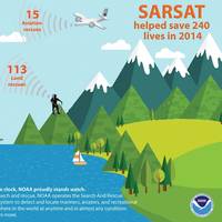
Last year, 240 people were saved from potentially life-threatening situations throughout the United States and its surrounding waters with help from NOAA’s fleet of weather satellites. In addition to their role in weather forecasting, NOAA’s polar-orbiting and geostationary satellites can detect distress signals from emergency beacons carried by downed pilots, shipwrecked boaters and stranded hikers. Information captured from these satellites, including location, are then relayed to first responders on the ground who assist with search and rescue efforts.
NOAA Satellites Helped Save 253 People in 2013
The same NOAA satellites that helped forecasters predict severe weather, such as the Moore, Okla., tornado last May and November’s deadly Midwest tornado outbreak, also played a key role in rescuing 253 people from potentially life-threatening scenarios throughout the United States and its surrounding waters last year. A combination of NOAA polar-orbiting and geostationary satellites detected distress signals from emergency beacons carried by downed pilots, shipwrecked boaters and stranded hikers and relayed information about their location to first responders on the ground.
LOC Expands to Australia's East Coast

London Offshore Consultants (LOC), a global marine and engineering consultant for the shipping and offshore energy sectors, announces plans to increase its presence in Australia. Identifying a strategic growth plan which allows the group to maintain quality and improve client response time, satellite operations, firstly in Sydney, and then the surrounding region, will be opened to support the existing operation in Perth. The expansion announcement comes in the same month as LOC celebrates its 25th anniversary in Australia.
Harris Helps Prepare NOAA GOES-R Extreme Weather Satellite
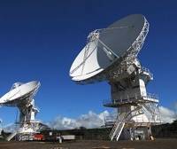
International communications and information technology company, Harris Corporation, has delivered a system that will help prepare National Oceanic and Atmospheric Administration (NOAA) satellite operators for the new Geostationary Operational Environmental Satellite – R (GOES-R) Series weather satellites, a primary tool for detecting and tracking hurricanes and severe weather. The new Mission Management Capability enables operators to prepare ground-based satellite command and control operations and processes more than two years ahead of the launch of the first GOES-R satellite. A NOAA and NASA team also will use the Harris system to test the command and control procedures with the satellite as it is assembled by mission partner Lockheed Martin.
Intelsat Announce Numerous Executive Appointments.

Intelsat’s Board of Directors elected Dave McGlade, currently Deputy Chairman and Chief Executive Officer, to the position of Chairman and Chief Executive Officer, effective April 1, 2013. Mr. McGlade has served as the Company's Chief Executive Officer for eight years. Mr. McGlade has appointed Stephen Spengler to the position of President and Chief Commercial Officer, effective March 18, 2013, a new role for the Company. Mr. Spengler has been with Intelsat in various executive positions since 2003, most recently serving as Executive Vice President, Sales, Marketing and Strategy. Mr.
NOAA Satellites Aid in 263 Rescues in 2012
The same NOAA weather and climate satellites that accurately tracked Hurricane Sandy’s path in October also played a key role in rescuing 263 people in 111 emergencies in the United States and surrounding waters in 2012. Since NOAA’s seven operational satellites circle the globe or sit above the United States, they also carry instruments to detect distress signals from emergency beacons carried by downed pilots, shipwrecked boaters and stranded hikers. In addition to their role in weather prediction…
USN Accepts First MUOS Satellite for Operations
U.S. Strategic Command (USSTRATCOM) has accepted the first Mobile User Objective System (MUOS) satellite for initial operational use. MUOS is a next-generation narrowband tactical communications system designed to improve communications for U.S. forces on the move. The Naval Satellite Operations Center (NAVSOC) at Point Mugu, Calif., began "flying" the satellite in June. In addition to providing continuous communication for all branches of the U.S. military, Navy delivered space…
Navy Launches Communications Satellite
CAPE CANAVERAL AIR FORCE STATION, Fla. (NNS) -- The Navy's first Mobile User Objective System satellite was launched Feb. 24 from Space Launch Complex 41. MUOS is a next-generation narrowband tactical communications system designed to improve communications for U.S. forces on the move. MUOS will provide military users simultaneous voice, video and data capability by leveraging 3G mobile communications technology. Born from the need for stable, 24/7 ship-to-shore communication that could be successful regardless of environments and geographical conditions…
NOAA Satellites Help Rescue 207 in 2011

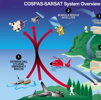
In 2011, NOAA satellites were critical in the rescues of 207 people from life-threatening situations throughout the United States and its surrounding waters. The satellites picked up distress signals from emergency beacons carried by downed pilots, shipwrecked boaters and stranded hikers, and relayed the information about their location to first responders on the ground. NOAA’s polar-orbiting and geostationary satellites are part of the international Search and Rescue Satellite Aided Tracking System, called COSPAS-SARSAT.
New USACE Contracts
Dutra Dredging Co., San Rafael, Calif., was awarded on May 15, 2009 an $18,224,915 firm-fixed-price contract for Harbor Improvements Phase III, St. Paul, Alaska, St. Paul, Alaska Dredging approximately 150,000 Cubic Yard (CY) for the entrance channel, maneuvering area, mooring area, and the intertidal beach area, dredging approximately 27,000 CY for the breakwater berth dredge area (optional item), demolish an existing rubblemound breakwater, construct a 435-foot long rubblemound breakwater (attached) in the existing harbor, construct a 160-foot long rubblemound breakwater (detached) in the existing harbor, construct a 485-foot long rubblemound circulation berm in the existing harbor. Work is to be performed in St. Paul Island, Ala., with an estimated completion date of Jan. 25, 2012.
Station 12 Strives To Corner Satcom Market
The competitive satellite communications market has taken an additional step toward consolidation, with Station 12 — an independent operating business owned 65 percent by KPN (Royal Dutch Telecom) and 35 percent by Telstra — leading the way having the intention of cornering the market. Station 12 recently outlined its strategy to double its size in the next three years, both through organic growth and acquisitions. Station 12 already claims to have 24 percent of the competitive Inmarsat maritime and mobile satellite communications sector, with current annual sales of $215 million. This is expected to rise to $500 million by 2003. The company is the largest customer and shareholder in Inmarsat, the leading provider of wholesale satellite airtime.
Lockheed Martin Restructures Maritime Unit
In a move it describes to strengthen its competitive advantage in design and integration of combat systems and sensors for maritime and related markets, Lockheed Martin is further integrating its naval electronics and surveillance systems units into a single business enterprise called Maritime Systems & Sensors (MS2). This restructured company, with more than 11,000 employees, has significant operations in Akron, Ohio; Archbald, Pa.; Baltimore, Md.; Eagan, Minn.; Manassas, Va.; Syracuse, N.Y.; Moorestown, N.J.; Clearwater and Riviera Beach, Fla., as well as satellite operations in more than 70 locations, including 22 overseas. "Our objective is straightforward.


