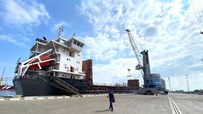
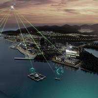
Charting Terradepth's Big Ambitions in the Unmanned Vehicle Space
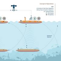
Ocean mapping at scale is the target of a new unmanned systems player started by two ex-US Navy SEALS. They have big ambitions, from new building unmanned vehicles to creating the intelligence that will drive them to changing how accessible ocean data is. Elaine Maslin learned more. The pace of change in the ocean mapping space has been fast in recent years. New entrants have come into the scene offering “force multiplier” mapping using autonomous underwater vehicles (AUVs) and unmanned surface vessels (USVs).
Maritime's Digital Transformation & Simulation-based Training
Nearly 200 delegates from across the world gathered in Den Haag, The Netherlands in September 2017 to hear about the latest developments in maritime training based on state-of-the-art simulation technology. The three-day Kongsberg UC2017 International Maritime Simulation User Conference brought attendees up to date on developments in digitalization, maritime training, navigation technology, maritime operations simulation and the use of virtual reality in training. Tom Mulligan reports.
BMT’s REMBRANDT-INLAND Simulation Tool
When a new or expanded port is planned on an inland waterway, how do you assure the civil marine engineers and ship operators of feasibility and operability while at the same time allaying the fears of local residents that their quality of life and local environment will not be significantly spoiled? “Simple,” says Paul Morter, Business Manager for BMT ARGOSS’s brown water version of their tried and tested ship simulator REMBRANDT. “You take the ships and the port to them. This is exactly what we did towards the end of 2014. It was BMT ARGOSS inland waterways specialist Johannes ‘Hans’ Veldman who identified a potential market for brown water simulation through his work experience with the Dutch inland waterway networks.
Acclaimed Launches EPOCH for OMM
Software specialists The Acclaimed Software Company Ltd. announced the development of EPOCH , a marine management system on behalf of Offshore Marine Management Limited (OMM). EPOCH is an ESRI-GIS, web-based management system, providing reporting from offshore sites to onshore bases. For example, OMM’s German subsidiary uses EPOCH to manage and control guard vessel operations for offshore wind interconnector installations in the German sector of the North Sea. The Acclaimed are inviting visitors to Oceanology International in March at London’s Excel Center to try out this novel management tool on their Stand Number H555. EPOCH allows operators to manage their offshore assets, vessels, operations, personnel and data from one comprehensive system.