EU-backed Autonomous Shipping Project Moves Forward
Hull to Hull (H2H), an EU-funded research project established to develop technical solutions for safer navigation in close proximity of other stationary or moving vessels and objects, is in its Concept Definition phase and will move on to the Technology Adaption and Integrations Work Package (WP03) this summer.H2H was established in November 2017 to develop solutions using the European Global Navigation Satellite System (EGNSS), EGNOS and Galileo, that can enhance safety in busy waters and during close maneuvering…
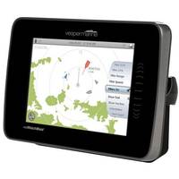
Vesper Marine Debuts New AIS Transponder
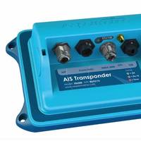
Marine safety products manufacturer Vesper Marine has released a new Class B Automatic Identification System (AIS), the XB-6000. The black box transponder includes a built-in NMEA 2000 gateway and GPS antenna that integrates AIS, GPS and NMEA instrument data to display vital safety information on any AIS-compatible chartplotter, multifunction display (MFD) or personal computer. The Vesper Marine XB-6000 offers convenient access to AIS safety information instantaneously while on the water.
Simrad Launches New Pro Line Products
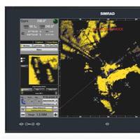
Simrad launched three new products in its professional line: the HS60 GPS Compass, V5035 Class-A AIS, and M5000 Series Monitors. The new GPS compass, the HS60, brings expanded functionality to traditional heading sensors such as rate-of-turn and pitch-and-roll output. With these features, the HS60 provides a low-cost, effective smart antenna option. Using SimNet and NMEA 2000 data communication, the new Simrad HS60 provides accurate heading, pitch, roll and position data. With out-of-band interference rejection and two-degree RMS heading accuracy…
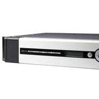
Simrad Launches New Pro Line Products
Simrad announced the launch of three new products in its professional line: the HS60 GPS Compass, V5035 Class-A AIS, and M5000 Series Monitors. The new GPS compass, the HS60, brings expanded functionality to traditional heading sensors such as rate-of-turn and pitch-and-roll output. With these features, the HS60 provides a low-cost, yet effective smart antenna option for marine vessels. Using SimNet and NMEA 2000 data communication, the new Simrad HS60 provides accurate heading, pitch, roll and position data.
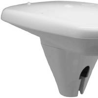
Vesper Marine Upgrades Watchmate
Marine Safety Leader Releases Industry’s Vesper Marine First AIS Devices With Built-in High Speed GPS Auckland, New Zealand – Vesper Marine, a leading manufacturer of innovative marine safety products, announced today powerful updates to its award-winning WatchMate Vision and XB-8000 product lines. Now, in addition to transmitting and receiving position, course, speed and vessel details for collision avoidance, both devices feature high-speed 5Hz GPS receivers making them the first Class B AIS transponders that can be used as a primary positioning sources for any chartplotter, multifunction display (MFD), autopilot or instrument display on an NMEA 2000 network.
New Functionality in WatchMate Vision
Vesper Marine has announced updates to its WatchMate Vision and XB-8000 product lines. Now, in addition to transmitting and receiving position, course, speed and vessel details for collision avoidance, both devices feature high-speed 5Hz GPS receivers making them the first Class B AIS transponders that can be used as a primary positioning sources for any chartplotter, multifunction display (MFD), autopilot or instrument display on an NMEA 2000 network. Vesper and its XB-8000 and WatchMate Vision now provide the option to enable high-speed GPS navigation computations.
SafePort Project Completes Successful Sea Trials

BMT Group, the international maritime design, engineering and risk management consultancy, is pleased to announce that the SafePort research project has completed initial sea trials of a prototype vessel management system at Dublin port. SafePort offers the first advanced vessel traffic management system designed for constrained ports, or waterways with high traffic densities, with integrated portable pilot unit. SafePort delivers accurate, secure and reliable navigation and positioning information which in turn enables for safer and more efficient navigation and berthing.
European Global Navigation Satellite System
The UK Department for Transport summarized the Department’s work on the European Global Navigation Satellite System programs Galileo and EGNOS. Galileo is the European Union’s global navigation satellite system (GNSS) and will be fully interoperable with the US GPS system. The European Geostationary Navigation Overlay Service (EGNOS) is the first pan-European satellite navigation system. It augments GPS, making it more suitable for safety-critical applications, such as navigating ships through narrow channels. (9/16/10). (Source: Bryant’s Maritime News)
New DGNSS From Kongsberg Seatex
Kongsberg Seatex, a specialist in position reference systems, has unveiled the latest additions to its DPS (Differential Position Sensor) product portfolio. Two new products, DPS 110 and DPS 112, have been developed to utilize the new Global Satellite Based Augmentation System (Global SBAS) introduced by the navigation specialist Fugro SeaSTAR AS, the SeaSTAR SGG service. This new high performance navigation service offers corrections to both GPS and GLONASS that enables sub-meter accuracy with worldwide reach.
Feature: Losing Contact ... Not an Option
Maritime communications is an estimated $1 billion industry, encompassing ship operators, merchant fleets, governments and private yacht owners. There is arguably no more quickly evolving technical sector in the maritime market than the satellite communications niche. Safety, operational efficiency and quality of life onboard vessels of all type and size today more than ever depends on clear, reliable and cost effective satellite communication services and products. The following reports on recent advances from major service, product and system suppliers. The year started with news that Connexion by Boeing, a business unit of The Boeing Company, would roll-out its high speed satellite broadband capability for the maritime industry.
Leica and NovAtel Will Develop Technologies For GPS
Leica Geosystems and NovAtel Inc. have entered an agreement to develop new technologies for global positioning systems (GPS). This is particularly relevant for equipment that will be based on the new upcoming Global Navigation Satellite Systems (GNSS). In the mid-eighties Leica Geosystems was one of the first companies to develop and market GPS surveying systems. NovAtel, founded in 1978, also has the reputation of being one of the most successful innovators of advanced concepts in GPS technologies. These include significant contributions to the development of Satellite Based Augmentation Systems (SBAS) such as WAAS, MSAS and EGNOS.
Simrad Launches Type-Approved AIS
Simrad launched an Automatic Identification System (AIS) package at NorShipping. The Type Approved Simrad AI70 is designed to be a compact and user friendly unit which is able to broadcast specific vessel information. The AI70 is also able to receive other vessels broadcast data. A wealth of information can be utilized including vessel ID, cargo type, destination etc. and shore based stations. information and is also equipped to handle the forthcoming European Global Navigation Overlay System (EGNOS). The Simrad AI70 is based on the Kongsberg Seatex AIS 100 system, which is already proven in the offshore markets and known for its record breaking VHF range.