NOAA: New AK Chart Makes Arctic Safer

NOAA: New Alaska navigational chart makes increased Arctic shipping safer; Kotzebue Harbor chart replaces measurements last taken in 19th century.
NOAA formally presented today to Alaska officials a new nautical chart for Kotzebue Sound in the Alaskan Arctic, a sparsely charted region that is seeing increased vessel traffic because of the significant loss of summer sea ice.
The new chart depicts the full range of depth measurements and object detection acquired during a full ocean bottom survey last summer by the NOAA hydrographic survey ship Fairweather. It replaces a chart showing depth measurements last taken in the 19th century spaced three to five miles apart, leaving room for possible undetected dangers in between.
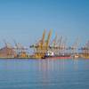
The new navigational chart addresses a pressing need for this Northwest Alaska transportation hub, located in the Arctic Circle. Barge shipments and large transport ships must be anchored at least 14 miles out in the Kotzebue Sound due to shallow waters and inadequate charts and navigational aids. Freight must then be transferred by smaller barges to Kotzebue.
"This new chart is just one of the many critical navigational services that NOAA provides to support safe navigation and maritime commerce while protecting important marine resources," said Kathryn D. Sullivan, Ph.D., deputy NOAA administrator and assistant secretary of commerce for environmental observation and prediction. "Based on stakeholder discussions and developing Arctic vessel traffic patterns, NOAA will improve the existing charts and navigational data to position the regional maritime economy to meet emerging opportunities, as we expand our commerce and energy sectors into the Arctic region."
Sullivan presented the chart to Alaska Lt. Governor Mead Treadwell during NOAA's Hydrographic Services Review Panel meeting in Anchorage.
Using millions of precise depth measurements gathered by Fairweather last summer, the new chart will give mariners a much better - and safer - map. Fairweather's hydrographic surveys of critical areas of the sound will improve safety and efficiency of freight transfer operations.
"With the reduction in Arctic ice coverage, we are starting to see growing shipping traffic in the Arctic, and this growth is driving an increase in maritime concerns," said NOAA Corps Capt. David Neander, who was the commanding officer of the NOAA Ship Fairweather during the survey. "Starting in 2010, we began surveying in critical Arctic areas where marine transportation dynamics are changing rapidly. These areas are increasingly transited by the offshore oil and gas industry, cruise liners, military craft, tugs and barges and fishing vessels."
The new chart, number 16161, depicts measured ocean depths at a scale of 1:50,000. An inset for Kotzebue Harbor will have even more detail, with a scale of 1:25,000. Mariners had been using a chart with a 1:700,000 scale, mostly depicting water depths measured in the 1800s, before technology was able to acquire data with today's level of precision and accuracy, and before today's increased shipping necessitated updating of these navigational surveys.
"With the new chart, mariners who are unfamiliar with the region will have more information and can make better decisions when they approach Kotzebue," said Capt. Doug Baird, chief of NOAA Coast Survey's marine chart division. "The chart has accurate and precise depth measurements, which will make ocean-going vessel traffic more efficient through northwest Alaska. Most importantly, the improved navigational information will help mariners protect life and property, on board ship and in the coastal waters of Kotzebue."
The charts were made available to the public on May 11, as an online Print on Demand chart through OceanGrafix.
About one third of U.S. Arctic waters are important to navigation, based on water depth, the draft of ships transiting the region, and the potential for unknown hazards or dangers to navigation. NOAA's Office of Coast Survey has identified 38,000 squares miles as its surveying priority and estimates it will take more than 25 years to complete updated charts for this area.
NOAA's Office of Coast Survey is the nation's chartmaker. Continuing a heritage of service to the maritime transportation system, Coast Survey has been America's trusted source of navigational charts, data, and services for two centuries.
NOAA Ship Fairweather is part of the NOAA fleet of ships and aircraft operated, managed and maintained by NOAA's Office of Marine and Aviation Operations, which includes commissioned officers of the NOAA Corps and civilian wage mariners.