NOAA
The National Oceanic and Atmospheric Administration (NOAA) is a scientific agency within the United States Department of Commerce. It focuses on the conditions of the oceans, major waterways, and the atmosphere. Established in 1970, NOAA plays a key role in understanding and managing the environment and natural resources.
Here are some of NOAA's primary functions and areas of responsibility:
Weather Forecasting and Warnings: NOAA's National Weather Service (NWS) provides weather forecasts, warnings for severe weather, and other weather-related information to ensure the safety of the public and the protection of property.
Climate Research: NOAA conducts research on climate trends and changes. This includes monitoring atmospheric conditions, studying long-term climate patterns, and providing data that can be used to make predictions about future climate conditions.
Marine and Coastal Resource Management: NOAA manages marine fisheries, protects marine habitats, and works to sustain populations of various marine species. The organization is involved in the conservation and management of marine and coastal ecosystems.
Ocean Exploration: NOAA is involved in exploring the world's oceans, mapping the seafloor, and discovering marine life and underwater geological formations. This contributes to our understanding of oceanic processes and marine biodiversity.
Environmental Monitoring: NOAA operates a network of satellites and observation systems to monitor environmental conditions on Earth. This network provides critical data for weather forecasting, climate monitoring, and the study of natural phenomena.
Research and Education: NOAA conducts and supports research to enhance our understanding of environmental issues. It also offers educational programs and resources to promote environmental literacy and encourage careers in science and technology.
Emergency Response: NOAA provides essential data and services during natural disasters and emergencies such as hurricanes, tsunamis, and oil spills, offering guidance and support for response and recovery efforts.
NOAA's work is critical for disaster preparedness, environmental conservation, and scientific research, influencing a wide range of sectors including agriculture, transportation, commerce, and public health.
NOAA's headquarters is located in Silver Spring, Maryland, but it has numerous laboratories, research facilities, and operational centers across the United States and its territories. NOAA partners with other government agencies, international organizations, and private sector entities to achieve its mission and objectives.
government
- Phone: 206.553.5749
- Web: www.noaa.gov
- Fax: 206.553.4340
Locations
NOAA News
NOAA Releases Final Ocean Noise Strategy Roadmap
NOAA has released its final Ocean Noise Strategy Roadmap, which will guide the agency in more effectively and comprehensively managing ocean noise effects on marine life during the next decade.
NOAA Aid to Protect Marine Mammals
NOAA Fisheries awarded nearly $3 million in grants to support the conservation and recovery of protected marine species through stranding response and marine mammal rescue and rehabilitation.
NOAA Engineers a Better Current Sensor for Mariners

Navigating into seaports is now safer and more efficient for mariners thanks to improved NOAA technology that ships rely on to give them information about currents. The Center for Operational Oceanographic Products and Services (CO-OPS) developed a more reliable, cost-saving version of a current sensor system that can now be placed at more remote locations along navigation channels. The updated Acoustic…
Art Anderson Associates Wins 5-year NOAA Deal
Art Anderson Associates informs it has been awarded a five year Blanket Purchase Agreement (BPA) for program and project management as well as other services supporting…
NOAA Orders Research RHIB from Willard
Willard Marine, Inc.was awarded a contract by the National Oceanic Atmospheric Administration (NOAA) to produce a 20’08” rigid hull inflatable boat for the Pacific…
NOAA Declares Whale Deaths an ‘Unusual Morality Event’
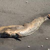
The U.S. National Oceanic and Atmospheric Administration (NOAA) has declared the recent deaths of 30 large whales in the western Gulf of Alaska an "unusual mortality event," triggering a focused, expert investigation into the cause. An unusual mortality event is a stranding event that is unexpected, involves a significant die-off of a marine mammal population and demands immediate response. Since May 2015…
Art Anderson Associates Awarded 5-year NOAA Contract
Engineering services firm Art Anderson Associates has been awarded a five-year blanket purchase agreement for naval architecture and engineering design services…
NOAA Issues Whale Advisory to Mariners

The National Oceanic and Atmospheric Administration (NOAA) broadcasted an advisory concerning populations of endangered whales off the coast of California, stating large numbers of endangered whales are being observed along the coastline. Voluntary vessel speed reduction zones are currently in effect for the San Francisco and Santa Barbara traffic separation schemes (TSS). NOAA is asking mariners to help track whales by reporting whale sightings…
NOAA Deploys Survey Ships for Arctic Charting Projects
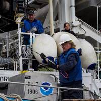
NOAA announced the official launch of its 2015 Arctic hydrographic survey season took place this morning, in Kodiak, Alaska, in a World Ocean Day ceremony which showcased the deployment of the NOAA ships Rainier and Fairweather. “Most Arctic waters that are charted were surveyed with obsolete technology, with some of the information dating back to Captain Cook's voyages, long before the region was part of the United States,” said NOAA deputy under secretary for operations Vice Admiral Michael S.
NOAA to Explore Depths of Caribbean Sea
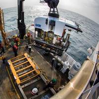
Public can watch seafloor discoveries live online April 9-30. Beginning April 9, scientists aboard NOAA Ship Okeanos Explorer will begin a series of 20 dives to investigate previously unseen depths of the Caribbean Sea and Atlantic Ocean – and the public can follow along online. During dives that are expected to go as deep as 3.7 miles, a sophisticated unmanned submarine, called a remotely operated vehicle…
NOAA to Boost Arctic Nautical Charting
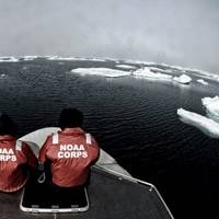
NOAA plans increased 2015 Arctic nautical charting operations, coordinating with U.S. As commercial shipping traffic increases in the Arctic, NOAA informs it is taking steps to update nautical charts in the region. NOAA’s Office of Coast Survey will use data collected by two of its own ships, Rainier and Fairweather, as well as the U.S. Coast Guard cutter Healy and a private sector hydrographic contractor to cover nearly 12…
Vice Adm. Brown Confirmed as NOAA Deputy Administrator

Retired Coast Guard Vice Adm. Manson Brown was appointed by President Obama and confirmed by a voice vote of the U.S. Senate to serve as assistant secretary of commerce for environmental observation and prediction and deputy administrator for NOAA. Brown joins NOAA after 36 years of service in the U.S. Coast Guard. As deputy administrator, Brown will play a major role driving the Obama administration and NOAA priorities for weather and water services…
New Lineup for NOAA Hydrographic Services Panel
NOAA administrator Kathryn Sullivan, Ph.D., has appointed six members to the Hydrographic Services Review Panel, a federal advisory committee that gives NOAA independent advice for improving a range of services and products that support navigation and coastal resilience. Capt. “Providing coastal communities, boaters, and the commercial maritime industry with timely, reliable, accurate, and authoritative information is essential as we strive to keep commerce flowing through our nation’s ports…
NOAA Satellites Help Rescue 240 People Last Year
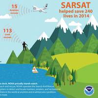
Last year, 240 people were saved from potentially life-threatening situations throughout the United States and its surrounding waters with help from NOAA’s fleet of weather satellites. In addition to their role in weather forecasting, NOAA’s polar-orbiting and geostationary satellites can detect distress signals from emergency beacons carried by downed pilots, shipwrecked boaters and stranded hikers.
USCG, NOAA Ink Fleet Plan Agreement

Senior leaders from the U.S. Coast Guard (USCG) and the National Oceanic and Atmospheric Administration (NOAA) signed a Fleet Plan and Officer Exchange memorandum of understanding Wednesday at a ceremony at U.S. Coast Guard Headquarters. Coast Guard Vice Adm. Charles Michel, deputy commandant for operations, and NOAA Vice Adm. Michael Devany, deputy under secretary for operations, were the signing officials for the joint letter of promulgation.
NOAA Orders Newbuild Navigation Response Boats
NOAA today announced that Lake Assault Boats of Superior, Wisconsin, will build two small vessels for the Office of Coast Survey's navigation response program, part of a plan to eventually replace all six of the program's small survey boats. The combined cost of both 28-foot vessels is $538,200. "All of the navigation response team survey boats are nearing or have exceeded their designed service life," said Russ Proctor, division chief of Coast Survey's Navigation Services Division.
NOAA Expands Thunder Bay National Marine Sanctuary
NOAA today released a final rule and environmental impact statement expanding the boundaries of Thunder Bay National Marine Sanctuary in Lake Huron from 448 square miles to 4,300 square miles.
US Warships Evacuate NOAA Pacific Island Researchers
Sailors and Marines from the Makin Island Amphibious Ready Group (ARG) and 11th Marine Expeditionary Unit (MEU) have conducted an emergent recovery of 11 researchers…
TerraSond Gets 5-Year NOAA Survey Contract
TerraSond says it has been selected by the National Oceanic and Atmospheric Administration (NOAA) to provide hydrographic surveying services anywhere in the U.S under a new five-year contract.
NOAA Reports 2011 Ocean, Great Lakes Economy Data
NOAA’s newest output includes a feature on economics. The National Ocean Watch site features facts, charts, story maps and videos. It turns out that our maritime economy – commercial, recreational and everything in between – really matters. In 2011, the U.S. Ocean and Great Lakes economy produced $282 billion in goods and services and employed 2.2 percent of the nation’s workers—that’s more than twice the percentage of workers in the U.S. agriculture industry.