NOAA
The National Oceanic and Atmospheric Administration (NOAA) is a scientific agency within the United States Department of Commerce. It focuses on the conditions of the oceans, major waterways, and the atmosphere. Established in 1970, NOAA plays a key role in understanding and managing the environment and natural resources.
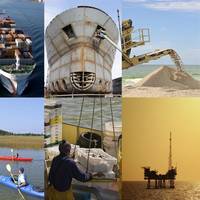
Here are some of NOAA's primary functions and areas of responsibility:
Weather Forecasting and Warnings: NOAA's National Weather Service (NWS) provides weather forecasts, warnings for severe weather, and other weather-related information to ensure the safety of the public and the protection of property.
Climate Research: NOAA conducts research on climate trends and changes. This includes monitoring atmospheric conditions, studying long-term climate patterns, and providing data that can be used to make predictions about future climate conditions.
Marine and Coastal Resource Management: NOAA manages marine fisheries, protects marine habitats, and works to sustain populations of various marine species. The organization is involved in the conservation and management of marine and coastal ecosystems.
Ocean Exploration: NOAA is involved in exploring the world's oceans, mapping the seafloor, and discovering marine life and underwater geological formations. This contributes to our understanding of oceanic processes and marine biodiversity.
Environmental Monitoring: NOAA operates a network of satellites and observation systems to monitor environmental conditions on Earth. This network provides critical data for weather forecasting, climate monitoring, and the study of natural phenomena.
Research and Education: NOAA conducts and supports research to enhance our understanding of environmental issues. It also offers educational programs and resources to promote environmental literacy and encourage careers in science and technology.
Emergency Response: NOAA provides essential data and services during natural disasters and emergencies such as hurricanes, tsunamis, and oil spills, offering guidance and support for response and recovery efforts.
NOAA's work is critical for disaster preparedness, environmental conservation, and scientific research, influencing a wide range of sectors including agriculture, transportation, commerce, and public health.
NOAA's headquarters is located in Silver Spring, Maryland, but it has numerous laboratories, research facilities, and operational centers across the United States and its territories. NOAA partners with other government agencies, international organizations, and private sector entities to achieve its mission and objectives.
government
- Phone: 206.553.5749
- Web: www.noaa.gov
- Fax: 206.553.4340
Locations
NOAA News
NOAA Data Reveals Weight of Ocean and Great Lakes Economy
In 2011, the U.S. ocean and Great Lakes economy produced $282 billion in goods and services and employed 2.2 percent of the nation’s workers—that’s more than twice the percentage of workers in the U.S. agriculture industry. This fact and many others are featured in a 2011 data summary from Economics: National Ocean Watch (ENOW), a product of the National Oceanic and Atmospheric Administration (NOAA) Coastal Services Center.
NOAA Certifies 11Printers for Paper Charts

Mariners and the boating public have a wider choice of options and special services when they purchase NOAA paper nautical charts, thanks to NOAA's expanded "print-on-demand" chart production and distribution system. Coast Survey has certified eleven chart printing agents who have the flexibility to offer different color palettes, various papers, a cleaner margin, and a range of services. Under the program…
NOAA Offers a New Way to See Currents
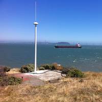
A new NOAA National Ocean Service website will provide mariners near real-time coastal ocean surface current observations and tidal current predictions in coastal waters using high frequency (HF) radar, making marine navigation safer for mariners and commercial shippers. The web-based observations are now available for the Chesapeake and San Francisco Bays in areas vital for marine navigation, with additional locations to follow.
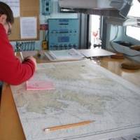
NOAA Begins Hydrographic Survey Season
New data will update nautical charts around the country. As sure as spring arrives, NOAA vessels and independent contractors are hitting the seas for the nation's 180th hydrographic surveying season, collecting data for over two thousand square nautical miles in high-traffic U.S. coastal waters. "Nautical charts are the foundation for the nation's maritime economy, and NOAA hydrographers spend months at sea…
NOAA Certifies More Printing Agents
The availability of paper "print-on-demand" nautical charts continues to expand, as NOAA's Office of Coast Survey has added three more printing companies to its roster of certified agents for paper charts. "The most recent printers to join the NOAA paper chart program represent the enduring connections between maritime tradition and progress," said Capt. Shep Smith, chief of Coast Survey's Marine Chart Division.
Three NOAA scientists honored by White House
The White House yesterday awarded three NOAA scientists with Presidential Early Career Awards for Scientists and Engineers. The award is the highest honor given…
NOAA Nautical Charts Now Permanently Free

After a three-month trial period, PDF versions of NOAA nautical charts will become a permanent product, free to the public. The free PDFs, which are digital images of traditional nautical charts, are especially valued by recreational boaters who use them to plan sailing routes and fishing trips. The free PDF charts are part of a suite of new and enhanced navigational products designed to make NOAA’s data more accessible to the general public.
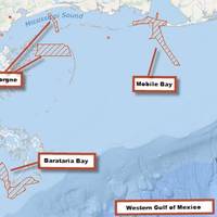
NOAA Creates Dynamic Whale Protection Area
The NOAA Fisheries Service has established a Dynamic Management Area near Savannah, Ga. to protect an aggregation of three whales sighted on January 23. Mariners…
NOAA Satellites Helped Save 253 People in 2013
The same NOAA satellites that helped forecasters predict severe weather, such as the Moore, Okla., tornado last May and November’s deadly Midwest tornado outbreak, also played a key role in rescuing 253 people from potentially life-threatening scenarios throughout the United States and its surrounding waters last year. A combination of NOAA polar-orbiting and geostationary satellites detected distress signals from emergency beacons carried by downed pilots…
No Fear, NOAA Paper Charts Still Near

The announcement that the federal government will stop bulk lithographic printing of nautical charts brought some understandable angst, however NOAA say they may be changing the chart production process but they will NOT stop the production of paper charts. The Agency explain they are working with private companies to make them better: printed in brighter colors and available for fast delivery to the door. Most importantly, they are up-to-date to the moment ordered.
NOAA Updates New York Harbor Charts Post-Sandy
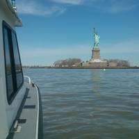
Ships, barges, ferries, and recreational boats in the busy New York Harbor will be able to navigate more safely thanks to an updated version of the harbor’s nautical chart recently issued by NOAA that includes data gathered in the navigational response to the damage caused by Sandy in October 2012. The latest edition of Chart 12334 – New York Harbor includes new depth measurements and shoreline depictions.
Arctic Marine Survey Work: NOAA & Coastguard Join Hands

With 3.4 million square nautical miles of U.S. waters to survey and chart, Coast Survey is up against some big challenges in keeping nautical charts current, consequently NOAA joins hands with the US Coast Guard to provide the best possible safety service to shipping. With the Alaskan coast comprising 57% of the U.S. navigationally significant waters, a multi-agency partnership for hydro survey data is necessary for maritime safety. Since 2008, NOAA has been working with the U.S.
NOAA Unveils New Electronic Chart Online Viewer
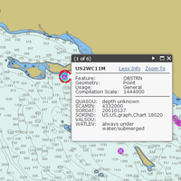
For more than ten years, since NOAA introduced its electronic navigational charts, you have needed to purchase a specialized chart display system to view the NOAA ENC® as a seamless chart database. Starting today, you don’t need a system to view the ENC depictions; you can use Coast Survey’s new web-based viewer called NOAA ENC® Online . (IMMEDIATE CAVEAT: You still need a specialized display system to use the multi-layered functional data that make ENCs so valuable.
Tell NOAA If You Think the IWR Still Needs the 'Magenta Route'
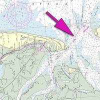
If you are a recreational boater, fisherman, or another member of the maritime community, NOAA's Office of Coast Survey wants to pick your brain about the "magenta line," which historically depicted the recommended route for the Intracoastal Waterway Route (IWR) on NOAA nautical charts. A recent Federal Register Notice outlines NOAA's options for improving the accuracy of the magenta line, which is presently being removed from new editions of nautical charts.
NOAA Reports Sustained Seafood Levels

An annual report released by NOAA stated U.S. commercial fishermen landed 9.6 billion pounds of fish and shellfish in 2012, valued at $5.1 billion, according to Fisheries of the United States 2012. The value and pounds of fish and shellfish caught remain higher than the average for the previous ten years of 9.2 billion pounds and $4.1 billion, although this represents a small decrease from the high level of landings and value in 2011.
Death Knell for NOAA Traditional Paper Nautical Charts
NOAA’s Office of Coast Survey has announced major changes ahead for mariners and others who use nautical charts. Starting April 13, 2014, the federal government will no longer print traditional lithographic (paper) nautical charts . NOAA will continue to provide other forms of nautical charts, including Print-on-Demand paper charts as well as electronic and digital formats. Since 1862, those lithographic…
Harris Helps Prepare NOAA GOES-R Extreme Weather Satellite
International communications and information technology company, Harris Corporation, has delivered a system that will help prepare National Oceanic and Atmospheric…
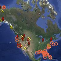
NOAA Identifies Lurking Environmental Threats

A new NOAA report that examines national oil pollution threat from shipwrecks has been presented to the U.S. Coast Guard. With as many as 20,000 recorded shipwrecks in NOAA’s database, the May 2013 report finds that just 36 sunken vessels scattered across the U.S. seafloor could pose an oil pollution threat to the nation’s coastal marine resources. Of those, 17 were recommended for further assessment and potential removal of both fuel oil and oil cargo.
NOAA Awards $967,000 to 11 Marine Debris Removal Projects
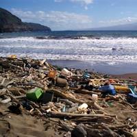
NOAA’s Marine Debris Program provided $967,000 through its Restoration Center to support locally driven, community-based marine debris prevention and removal projects. Eleven groups across the country received funding to remove derelict fishing nets, litter, lumber, tires and other harmful marine debris from shorelines and coastal waters. “Marine debris plagues coastlines all over the country, and these communities have the expertise and motivation to address it…
NOAA Updates Cobscook Bay Area Chart
Northern Maine vessels will be able to navigate more safely around the dangerous Cobscook Bay thanks to an updated version of the area's nautical chart issued by NOAA.