

NOAA Unveils New Electronic Chart Online Viewer
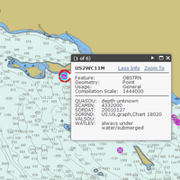
For more than ten years, since NOAA introduced its electronic navigational charts, you have needed to purchase a specialized chart display system to view the NOAA ENC® as a seamless chart database. Starting today, you don’t need a system to view the ENC depictions; you can use Coast Survey’s new web-based viewer called NOAA ENC® Online . (IMMEDIATE CAVEAT: You still need a specialized display system to use the multi-layered functional data that make ENCs so valuable. Since NOAA ENC Online is web-based, there is nothing to download.
Singapore & Malacca Straits Tide Models Released
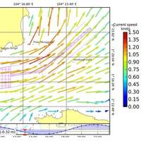
Recently developed commercial tidal models developed by applied oceanography specialist Tidetech for online viewing. The online viewer – OceanView – is an entry-level version of the company’s tidal models, viewable on any internet browser and on internet capable mobile devices. OceanView offers a highly detailed and accurate tidal current atlas featuring tidal current predictions at 1km resolution for every 30 minutes. Other features include latitude and longitude, place names, scale showing speed of current in knots (no interpolation necessary), and shipping lanes for easy reference.
Singapore and Malacca Straits Tidal Models Released

Recently developed commercial tidal models for the Singapore and Malacca Straits have been released in an exclusive online viewer. Developed by applied oceanography specialist Tidetech, the online viewer – OceanView – is an entry-level version of the company’s tidal models, viewable on any internet browser and on internet capable mobile devices. OceanView offers a detailed tidal current atlas featuring tidal current predictions at 1km resolution for every 30 minutes. Other features include latitude and longitude…
NOAA’s Newest Chart to Support Puerto Rico Maritime Economy
The Port of San Juan, which is experiencing a tremendous growth of maritime traffic and planning for more, received an additional economic boost today when NOAA debuted a new nautical chart that will make ocean-going vessel traffic safer and more efficient through San Juan Bay and the port area. “There is not only more traffic, but larger vessels are making San Juan their port call,” said Capt. John Lowell, director of NOAA’s Office of Coast Survey. “Mariners asked for NOAA’s help when they started finding themselves too far right of the port entrance,” Lowell said. “The San Juan harbor pilots knew the ship captains were at risk of endangering their vessels.
NOAA’s New Chart Supports Puerto Rico Maritime Economy

The Port of San Juan, which is experiencing a tremendous growth of maritime traffic and planning for more, received an additional economic boost today when NOAA debuted a new nautical chart that will make ocean-going vessel traffic safer and more efficient through San Juan Bay and the port area. “There is not only more traffic, but larger vessels are making San Juan their port call,” said Capt. John Lowell, director of NOAA’s Office of Coast Survey. “Mariners asked for NOAA’s help when they started finding themselves too far right of the port entrance,” Lowell said.


