

Fuel Savings Are Just a ‘Nudge’ Away
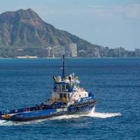
The commercial maritime industry is hard at work developing, testing and implementing new and innovative technologies to limit its environmental impacts. While much of the effort has focused on physical solutions such as improved hull design, cleaner burning engines and alternative fuels—all of which are important components of the industry’s decarbonization journey—software firm Signol has its sights set on helping vessel owners and operators reap the rewards of behavioral efficiencies.The…
New Ship Tracking Web App Unveiled
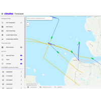
New web application provides enhanced analytics and visibility for satellite tracking of shipping vesselsGeodata ecosystem provider cloudeo has launched a new web app that aims to provide enhanced analytics, visibility and a simpler user experience for tracking the location and identification details of seafaring vessels.The new TimeCaster web app, available for purchase now in the cloudeo store, builds on the TimeCaster geoservices solution, which utilizes big data analytics to enhance ship tracking and forecasting methods.
Torqeedo Partners with Sentinel Marine Solutions and WhisperPower
Torqeedo has announced strategic agreements to integrate Sentinel Boat Monitors and WhisperPower smart power generation systems into its electric boat propulsion product offerings. The announcements were made in a press conference at the Dusseldorf International Boat Show Jan. 23. The Sentinel Boat Monitors are now fully integrated with Torqeedo’s Cruise, Travel and Ultralight electric propulsion systems. The Sentinel app allows remote monitoring of the vessel’s location and onboard systems, and provides automatic alerts of any malfunctions and alarms.
Forrest Lucas: The 'Every Man' Tycoon

Forrest Lucas is a proverbial ‘rags-to-riches’ story, emerging from rural Indiana to build a corporate empire. From truck driver to truck fleet owner to oil and media magnate – including naming rights to an NFL stadium – Lucas is the ‘every man’ tycoon with eyes on the commercial maritime market. Talk to Forrest Lucas for five minutes and it is easy to see that his claims to be a ‘regular guy’ – placing honesty and integrity at the forefront of all dealings – is earnest. Rising from modest means, early on Lucas combined an entrepreneurial spirit, a hard work ethic and an inventive mind.
Navionics SonarChart Compatible With Sounder
Navionics, the leader in content and location-based services for the recreational boating and outdoor markets, announced today the latest details of its award-winning SonarChart Live. Now offering compatibility with Raymarine Dragonfly PRO and Wi-Fish systems, boaters can connect GPS chartplotters, sounders and fishfinders with their mobile devices using Wi-Fi to view an HD bathymetry map in real time while navigating. Raymarine Dragonfly PRO and Wi-Fish users can also take advantage of the unique split-screen view within the Navionics Boating app, enabling them to display both charts and DownVision sonar in the palm of their hands. SonarChart Live is also now available for use with any sounder or plotter connected to a compatible Wi-Fi router, such as Digital Yacht’s Sonar Server.
Navionics Debuts SonarCharts
Navionics, the leader in location-based content for the recreational boating and outdoor markets, announced today the release of a new SonarCharts chart card for use with several Garmin GPS chartplotters. Featuring extraordinary bottom contour detail of up to 1 foot in the US and Canada, the new version of SonarCharts HD bathymetry map for use with several Garmin GPS chartplotters offers the most detail available anywhere, and is great for increasing awareness of shallow waters and locating fishing areas at any depth level. The SonarCharts card also includes navigational aids, providing a complete resource for all boating activities.


