OceanWise Delivers Maritime Information Infrastructure to Clydeport

Press Release
Thursday, November 08, 2012
File Clydeport Screenshot
Clydeport Screenshot

Independent marine data management, publishing and GIS specialist, OceanWise Ltd, has completed phase one of a maritime information infrastructure on behalf of Clydeport. 


The project builds on Clydeport’s recent investment in GIS software and was targeted at improving data and information management within the Hydrographic and Dredging Department.  The project is already realising tangible benefits and gaining a lot of interest from within the Marine Department as a whole and elsewhere in the port.


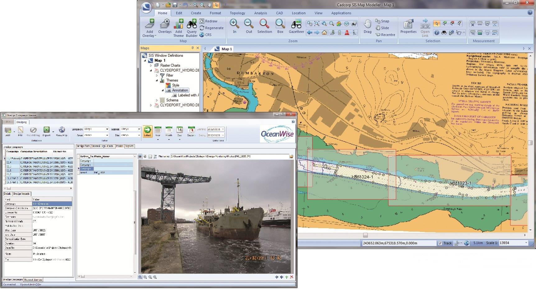
OceanWise’s work at Clydeport started with an analysis of existing practices and systems that resulted in the preparation of a GIS ‘Roadmap’ and Spatial and Environmental Data Management System to allow information to be shared and exchanged more easily between different business areas and with external stakeholders.  The infrastructure encompasses and complements Clydeport’s existing systems, not replacing them.  OceanWise’s relationship with specialist maritime software and equipment providers allows interfaces to be developed within Cadcorp SIS and Maritime Toolbar, so data can be shared as seamlessly as possible.    


At the centre of the infrastructure is Ocean Database installed on Microsoft SQL Server.  Cadcorp SIS connects directly to Ocean Database, with additional functionality provided by Maritime Toolbar.  Specific workflow requirements were addressed by installing Extensions to Maritime Toolbar for Hydrographic Survey, Dredging and Licensing, and Environmental Samples Management.  Further Extensions are available for recording, displaying and maintaining Infrastructure and Assets, such as Navigational Aids, Wrecks and Obstructions, Moorings etc.  


Dr Mike Osborne, OceanWise’s MD stated, “We are delighted to be working with Clydeport, whose personnel have embraced new and open technologies to improve data sharing and efficiencies across their operations.  This is an excellent example where GIS, carefully implemented, can achieve fantastic results”.   Douglas Hoad, Clydeport’s Hydrographic and Dredging  Manager, explains, “We already thought GIS could help improve the way we worked with data.  However, OceanWise’s expertise, industry knowledge and software tools have allowed us to realise these improvements in an incremental way. We look forward to continuing our relationship with OceanWise in the future.”


Find out more about OceanWise, Marine GIS and the Clydeport project at our free to attend Maritime Workshop on 20 November 2012 in London.

Email AddThis Feed Button
Maritime Reporter May 2013 Digital Edition
FREE Maritime Reporter Subscription
Latest Maritime News    rss feeds

Technology

Offshore Wind Spend to Average $21B per year

Douglas-Westwood (DW) forecast offshore wind installations averaging 3.2 GW per year over the next ten years with capital expenditure hitting a peak of $24.1B in 2016.

Liebherr Delivers Heavy Lift Offshore Crane For “Vidar”

In June, components weighing up to 420 tonnes each for Liebherr’s new heavy lift offshore crane CAL 45000-1200 Litronic  were loaded from Liebherr MCCtec Rostock

Macro Sensors' New Subsea LVDT Measurement Devices

US-based Macro Sensors introduces a line of submersible LVDT Position Sensors for use as part of subsea measurement systems. Macro Sensors say that their LVDTs

Marine Electronics

Northrop Grumman Upgrades Arklow Shipping ECDIS Systems

Northrop Grumman Corporation has been selected by Arklow Shipping to upgrade 12 container vessels with VisionMaster FT Electronic Chart Display & Information Systems (ECDIS).

ASA Electronics Partners with Independent Boat Builders

ASA Electronics, an international manufacturer of audio and video electronics and appliances has partnered with the Independent Boat Builders, Inc. to be the video supplier of choice.

Australian Reef Pilots Win Safety Award

Australian Reef Pilots (ARP) and its technology suppliers have won an international award for technology which improves safety and efficiency for shipping on the Great Barrier Reef.

Ports

POLB Commissioners Elect Thomas Fields President

The Long Beach advertising executive & former city planning commissioner, will lead the commission for a 1-year term from 1, July 2013. Thomas Fields will succeed Commissioner Susan E.

ABB to Play Role in Protecting Venice

ABB’s Symphony Plus control system to help protect Venice from high water flooding at the long Venetian Lagoon Malamocco inlet. Every four years or so, text messages,

China Container Terminal Cargo Volumes Surge

Chongqing Container Terminal in Southwest China reports container volume up 29.7% to 166,000 teu in Q1 2013. Import and export container volume climbed 29.7 per cent to 166,000 TEU.

Navigation

Northrop Grumman Upgrades Arklow Shipping ECDIS Systems

Northrop Grumman Corporation has been selected by Arklow Shipping to upgrade 12 container vessels with VisionMaster FT Electronic Chart Display & Information Systems (ECDIS).

Port of Red Dog: Bulk Carriers' Call of the Wild

The UK P&I Club issue information for members whose vessels call at the remote Alaskan port on the Arctic Circle. Red Dog is a port established specifically to

Australian Reef Pilots Win Safety Award

Australian Reef Pilots (ARP) and its technology suppliers have won an international award for technology which improves safety and efficiency for shipping on the Great Barrier Reef.

Communication

US Coast Guard to Terminate Guard on 2 mHZ Frequencies

Effective 01 August, 2013, the U. S. Coast Guard will terminate its radioguard of the international voice distress, safety and calling frequency 2182 kHz and the

New SatCom Test Deliver 50 Mbps to Superyachts

VT iDirect announce that OmniAccess S.L., communications provider to superyacht & megayacht owners, has successfully launched a live satellite communications network built on iDirect's latest iDX 3.

Iridium NEXT Sets the Global Communications Bar Higher

Expected to begin launching in 2015, Iridium NEXT is the next-generation satellite constellation & the world’s largest ongoing commercial space venture. The new system,

Software Solutions

QinetiQ Updates Ship Design Software

QinetiQ Maritime’s Paramarine software, a ship and submersible design tool, has released its latest version of software including a number of new capabilities. The

NAUTIS Simulators Introduce Interface to PC Maritime ECDIS

VSTEP and PC Maritime have jointly developed a software interface which they say makes high quality, yet affordable ECDIS and radar training possible. Following

Veson Enhance Veslink Software

Veson Nautical, developer of commercial maritime software, formally announced major Veslink enhancements to a crowd of over 150 maritime leaders at its annual ONCOURSE User Conference in Boston, Mass.


mobi | rss feeds | archive | history | articles | privacy | contributors | top news | about us | copyright