Mobile App Boosts Navigation Safety

press release
Thursday, January 17, 2013
File image illustrating depths of Houston / Galveston Ship Channel
image illustrating depths of Houston / Galveston Ship Channel

Conrad Blucher Institute Develops Mobile App to Increase Navigational Safety along Nation’s Second-Largest Port.
 

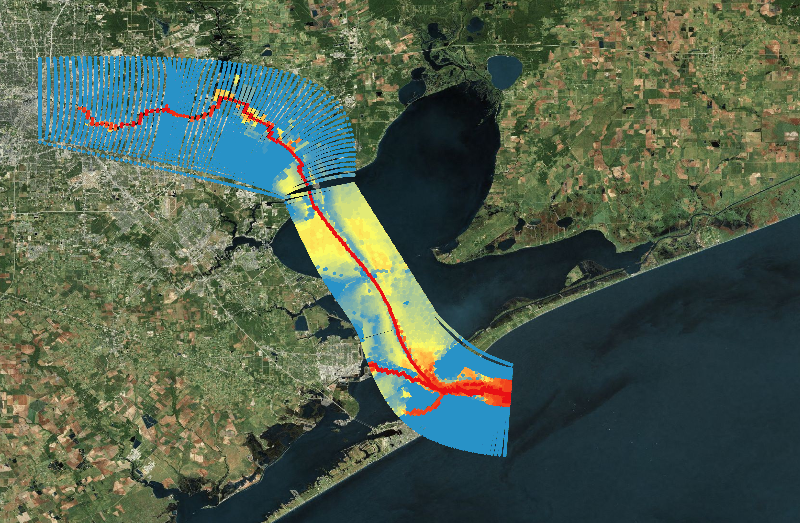
Researchers have designed and are implementing a new mobile application to provide ship captains and pilots with real-time predictions of ocean water levels and currents along the Houston Ship Channel, which services the second-largest port in the United States, the ports of Houston and Galveston.
 

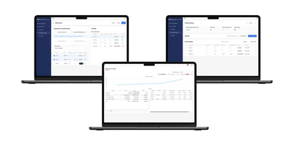
The app will provide invaluable information, which could increase navigational safety along the ship channel by reducing the number of ships becoming grounded due to insufficient water depth, and help reduce the number of vessel collisions. The “Transit Time!” Mobile App (http://apps.proto.cbi.tamucc.edu/transit), now available for mobile devices, smartphones, and desktop devices, will benefit the commercial navigation community, while future planned extensions of the app will help a broader base of coastal users.
 

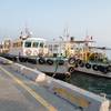
The Houston-Galveston Ship Channel, part of the second largest port by tonnage in the U.S., is used by more than 700 vessels daily, according to the U.S. Coast Guard. And, although Houston pilots use a commercial system to help them navigate through the port, most ships traveling in the Houston/Galveston ship channel are tug boats and barges with more than 128,000 transits each year. Many of these tug boat captains do not benefit from the current commercial navigation system.
 

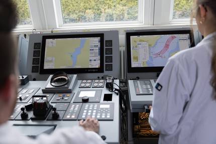
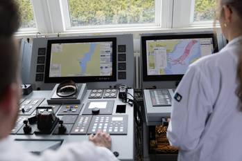
Sophisticated models that illustrate the mapping and charting of the ocean’s topographic features are run several times daily by the National Oceanic and Atmospheric Administration (NOAA), Center for Operational and Oceanographic Products and Services (CO-OPS).
 

“We’re taking gigabytes of the latest information and finding ways to make it useful to coastal users, said Dr. Philippe Tissot, Associate Director of the Conrad Blucher Institute. “Our ‘Transit Time’ application takes this information and uses mobile technologies to present it in a user-friendly format to ship captains and pilots navigating the Houston-Galveston ship channel.”
 

For example, Tissot says ”Transit Time” combines modeled and real-time data with the speed and position of the user’s mobile device to predict water levels and currents along the ship channel up to five hours in advance.  Factors such as tides, currents, and wind can contribute to incidents, and add to fuel consumption and a longer transit time. The mobile app can also help determine if larger ships have enough clearance to make it through the ship channel.
The Transit Time! Mobile App for Houston/Galveston PORTS was developed through collaboration between the Texas A&M-Corpus Christi Conrad Blucher Institute (CBI) and the NOAA CO-OPS.  Dr. Tissot and Scott Duff, Assistant Director for IT Operations at the CBI, led the project with programming conducted by students, Julien Clifford, Francesca Picarazzi, and former student Cristián Romo. While created for the Houston/Galveston ship channel, the application is in the process of being implemented for Chesapeake Bay, Va., and is designed to be used in other PORTS locations around the United States.  
 

“We have been developing a strong relationship with CBI over the past 20 years and these collaborative efforts can serve as a model for other state and federal partnerships” said Richard Edwing, director of NOAA CO-OPS.
CBI and CO-OPS began collaborating in 1988 when CO-OPS entered into an Agreement with the Texas General Land Office and the CBI to establish a network of water level stations installed and operated following NOAA standards, making Texas the first state to establish such a network. CBI also manages several coastal observation systems for NOAA including the Houston/Galveston and Sabine PORTSÓ (Physical Oceanographic Real Time System) as well as NOAAs National Water Level Observation Network (NWLON) stations in Texas.

Email AddThis Feed Button
Maritime Reporter May 2013 Digital Edition
FREE Maritime Reporter Subscription
Latest Maritime News    rss feeds

Technology

Offshore Wind Spend to Average $21B per year

Douglas-Westwood (DW) forecast offshore wind installations averaging 3.2 GW per year over the next ten years with capital expenditure hitting a peak of $24.1B in 2016.

Liebherr Delivers Heavy Lift Offshore Crane For “Vidar”

In June, components weighing up to 420 tonnes each for Liebherr’s new heavy lift offshore crane CAL 45000-1200 Litronic  were loaded from Liebherr MCCtec Rostock

Macro Sensors' New Subsea LVDT Measurement Devices

US-based Macro Sensors introduces a line of submersible LVDT Position Sensors for use as part of subsea measurement systems. Macro Sensors say that their LVDTs

Ports

POLB Commissioners Elect Thomas Fields President

The Long Beach advertising executive & former city planning commissioner, will lead the commission for a 1-year term from 1, July 2013. Thomas Fields will succeed Commissioner Susan E.

ABB to Play Role in Protecting Venice

ABB’s Symphony Plus control system to help protect Venice from high water flooding at the long Venetian Lagoon Malamocco inlet. Every four years or so, text messages,

China Container Terminal Cargo Volumes Surge

Chongqing Container Terminal in Southwest China reports container volume up 29.7% to 166,000 teu in Q1 2013. Import and export container volume climbed 29.7 per cent to 166,000 TEU.

Navigation

Northrop Grumman Upgrades Arklow Shipping ECDIS Systems

Northrop Grumman Corporation has been selected by Arklow Shipping to upgrade 12 container vessels with VisionMaster FT Electronic Chart Display & Information Systems (ECDIS).

Port of Red Dog: Bulk Carriers' Call of the Wild

The UK P&I Club issue information for members whose vessels call at the remote Alaskan port on the Arctic Circle. Red Dog is a port established specifically to

Australian Reef Pilots Win Safety Award

Australian Reef Pilots (ARP) and its technology suppliers have won an international award for technology which improves safety and efficiency for shipping on the Great Barrier Reef.

Maritime Safety

Breaking Down The Cost of MARPOL

Since January 8, 2009, United States (U.S.) and foreign flagged ships operating in the waters of the U.S. have been subject to MARPOL Annex VI. The Marine Environmental

Economic Impacts of STCW 2010

Our global economy and the maritime community have been greatly impacted by the implementation of the International Convention on Standards and Training, Certification

Crowley's 'Alert' Tugboat Commended for Alaska Rescue Tow

Representative Eric Feige from the Alaska State Legislature presents a letter of commendation to the 'Alert's crew for their rescue tow of drill barge 'Kulluk'.

Communication

US Coast Guard to Terminate Guard on 2 mHZ Frequencies

Effective 01 August, 2013, the U. S. Coast Guard will terminate its radioguard of the international voice distress, safety and calling frequency 2182 kHz and the

New SatCom Test Deliver 50 Mbps to Superyachts

VT iDirect announce that OmniAccess S.L., communications provider to superyacht & megayacht owners, has successfully launched a live satellite communications network built on iDirect's latest iDX 3.

Iridium NEXT Sets the Global Communications Bar Higher

Expected to begin launching in 2015, Iridium NEXT is the next-generation satellite constellation & the world’s largest ongoing commercial space venture. The new system,

Software Solutions

QinetiQ Updates Ship Design Software

QinetiQ Maritime’s Paramarine software, a ship and submersible design tool, has released its latest version of software including a number of new capabilities. The

NAUTIS Simulators Introduce Interface to PC Maritime ECDIS

VSTEP and PC Maritime have jointly developed a software interface which they say makes high quality, yet affordable ECDIS and radar training possible. Following

Veson Enhance Veslink Software

Veson Nautical, developer of commercial maritime software, formally announced major Veslink enhancements to a crowd of over 150 maritime leaders at its annual ONCOURSE User Conference in Boston, Mass.


mobi | rss feeds | archive | history | articles | privacy | contributors | top news | about us | copyright