Designated Risk Areas: Arbitrary Lines or Useful Tool for Illustrating Risk?

The art of drawing lines on maps is fraught with contention. Sir Mark Sykes and François Georges-Picot are likely unfamiliar to many, but their names and actions live on. Their role in carving up the Ottoman Empire toward the end of the of World War I created artificial borders in the Middle East—determined arbitrarily with a ruler and with no regard to ethnic or sectarian characteristics—highlights the unintended cartographic consequences that can arise when applying rigid models of expression to inherently dynamic areas.
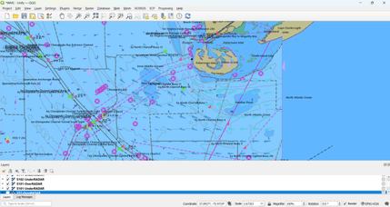
Designated areas of maritime risk, also known as High-Risk Areas (HRAs), have shown themselves to be similarly contested and controversial spaces. Countries whose territorial sea is part of a HRA have questioned the legitimacy of such areas, arguing that having their waters presented in such a manner has adverse implications for trade. Insurers, such as the Lloyd’s Market Association’s (LMA) Joint War Committee (JWC), use designated areas of risk as a reference point to define war risk zones for the purpose of providing their members with a clear and unambiguous point through which additional war risk premiums are applicable. The JWC comprises underwriting representatives from the LMA and the International Underwriting Association (IUA). Usually meeting quarterly and when required by exception, it is responsible for reviewing, designating and updating areas of war risk to which additional premiums apply. The latest updates were issued by the JWC in circular 026/7. As part of the recent JWC adjustment, the Sultanate of Oman managed to secure the removal of western Omani ports and waters from the LMA’s JWC list after being added to the list in 2019. Kenya, after much lobbying, managed to have its EEZ removed from the designated risk area. Additions to the area were Oman's Musandam Governorate, and waters off Mozambique’s Cabo Delgado region.
The designated areas of risk laid out by the JWC stem from an earlier concept of a single HRA in the Indian Ocean. The spatial concept of HRAs was introduced in Version Three of the Best Management Practices (BMP) in 2010 to complement the International Recommended Transit Corridor (IRTC) and was defined as the area where piracy attacks have taken place. While not legally binding, the BMP protocols, and with it the HRA, were endorsed by several international bodies, including the UN Security Council, multiple states, and the Contact Group on Piracy off the Coast of Somalia (CGPCS). The gradual industry-wide adoption of the HRA framework has led them to become the central spatial definition in which the fight against piracy would take place. HRAs have since evolved to become a major tool transcending all aspects of the maritime security domain. However, the ownership and authority to define risk based on the parameters and locations of HRAs continues to be contested and is fraught with issues and unintended consequences.
Strengths and limitations
The persistence of the JWC HRA concept as the de-facto arbitrator of risk within the maritime domain is testimony to both its clarity of illustration and simplicity of application. At a fundamental level, the methodology of HRAs is highly effective at providing a baseline definition of key maritime risk areas globally, which allows for the effective and unambiguous application of War Risk premiums. In turn, this gives the wider shipping industry a clear benchmark against which to understand the commercial impacts from using specific trading routes. The JWC designated risk areas are aligned with BMP Guidelines and provide a complimentary and holistic understanding of risk areas alongside recommended mitigations.
The concept and efficacy of the JWC HRA remain fundamentally sound 12 years after initial implementation. However, the dynamic nature of risk is seldom captured by static methods of interpretation. Limitations of the JWC HRA model are often cited as a lack of geographic flexibility and an inability to articulate the nature of risk within such an area. It is, however, vital to note that this is not the primary utility of the JWC designated risk areas, and nor should its utility be judged as such.
Unintended consequences
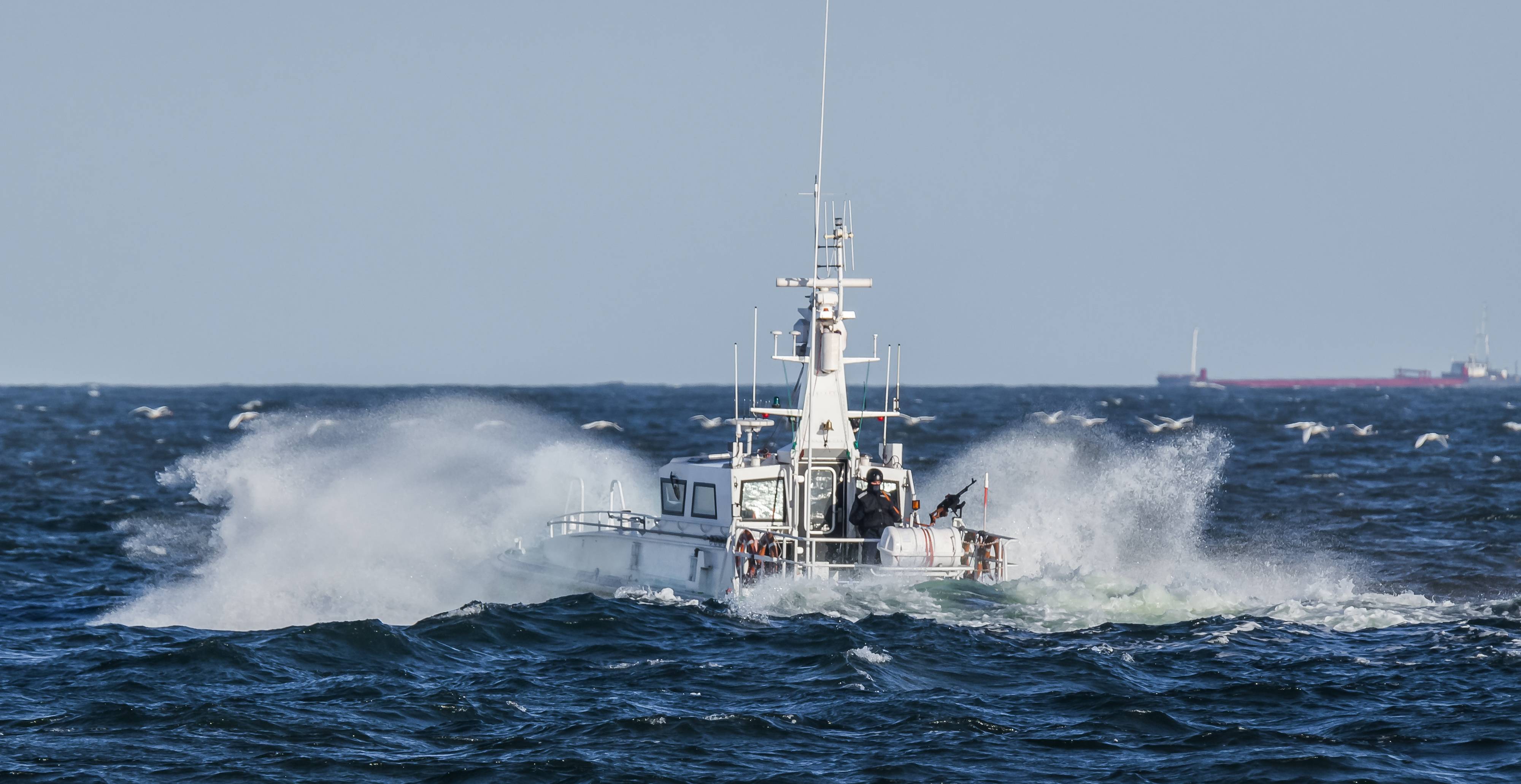
While the JWC HRA model allows underwriters the ability to stipulate mitigations, the framework itself does not aim to serve as a model against which commercial risk-based decisions are taken. This is, however, an unintended consequence arising from its prominence within maritime security frameworks. The risk environments encountered within the maritime domain are noteworthy for their complexity as much as their severity. Risk based decision-making remains an integral part of global shipping and is particularly prevalent when trading within complex environments. Decisions relating to routing and mitigation, including vessel hardening and the deployment of armed security, are often costly and time consuming and as such should be made after considering the true nature of risk as it is at the time of transit and not based on regional allocation.
As is perfectly illustrated within the Gulf of Guinea, serious incidents are not exclusive to defined areas of risk. Notwithstanding the expansion of the Gulf of Guinea HRA in September 2020 (JWC-025), there have been 10 serious maritime security incidents occurring beyond the immediate confines of this area since January 1, 2020. This stands in stark contrast to the current Indian Ocean HRA, which continues to extend 460 nautical miles beyond the shores of Somalia despite a near total absence of incidents. Whilst this presents significant issues for the wider underwriting process, companies taking risk-based decisions solely in line with the designation of an area of risk, do so at considerable risk to their crews and operations.
Clarity of risk
Beyond the geospatial nature of risk, there are issues of risk classification. The current HRA model falls short in providing clarity of the precise nature of risks within these areas. Consequently, companies should be cautious about employing standardized mitigations which may not reflect the risk at the time of transit. Examples of the dynamic nature of risk can be observed within the lower Red Sea and Gulf of Aden, where despite their continued inclusion within the JWC HRA, the principal risk has evolved from one of piracy to one of traditional war risk impacts. In line with this change in risk profile, there are significant cost implications for vessels failing to recognize such a dynamic shift and applying standardized mitigations in an incoherent manner.
While in the broadest sense, designated areas of risk have a profound utility, these can however be deeply misleading to companies when making risk-based decisions. The insurgency in Mozambique’s Cabo Delgado region has blighted the area for over a year. However, it was only in May of this year that the region became a designated HRA. In another example, attacks within the Bay of Campeche, Puerto Dos Bocas and Ciudad del Carmen within the Gulf of Mexico have shown a protracted and worrying upward trend in incidents yet remain free from designated risk area status.
Of economies and influence
The designation of risk areas is a task of considerable sensitivity and is no doubt one which the JWC does not take lightly. When designated areas of risk are drawn to include developing countries’ territorial waters, they can exacerbate existing negative socioeconomic conditions. Moreover, designated areas of risk and the associated premium and subsequent mandated mitigations can substantially increase the cost of trading in these areas.
In 2013, in response to the designated area including most of the north-western Indian Ocean, India, Oman and Egypt submitted requests to the Contact Group of Piracy off the Coast of Somalia (CGPCS) Working Group 3 for the boundaries to be reduced. In 2015, the boundaries were reviewed by the CGPCS to no longer include the Gulf of Oman, the Red Sea and both Pakistan and India’s Exclusive Economic Zones. Fifteen states in total sought the review of the risk area boundaries, including wealthy states such as Qatar, the United Arab Emirates and Saudi Arabia. The concerted effort of these states over four years to reduce the risk area boundaries and remove their territorial waters is indicative of how seriously the added cost of trading in designated risk areas impacts littoral states’ economies.
Furthermore, recent reports emerged that the Omani Sultanate successfully lobbied for its southern ports to be removed from the designated risk areas in the Arabian Sea in the latest boundary revisions. For Oman having initially been added in 2019 via JWLA 024 it was imperative to have the Port of Salalah removed from the area, so at least one strategically central port was not impacted by the added premiums and could better facilitate trade. Oman’s immediate reaction occurred because its leadership was cognizant of the significant economic impacts of being included within the risk areas carry. Less wealthy or influential states, such as Somalia, do not have the capability or capacity to effect such change, leading to enhanced barriers to trade and economic development of such states. These states are also the ones from which piracy often develops, with piracy and maritime crime themselves stemming from socioeconomic hardship onshore. The inadvertent disincentivizing of trade therefore risks contributing to the very problems it seeks to protect against.
It is beyond doubt that designated areas of risk in their current form are an important tool for maritime commercial operations, bringing much-needed clarity to the complex issue of benchmarking war risk insurance. However, it is also vital that commercial operators remain aware of the vulnerabilities in applying risk-based decision making against such areas without additional pre-transit due diligence. The process of designating areas as high risk, their utility in accurately portraying the true nature of risk in a timely manner, and their subsequent use in mandating mitigations should be subject to continuous independent review. For all commercial operators, the designation of areas as High Risk must not be taken as de facto and seen as a sufficient alternative for independent transit risk assessments. It is vital that independent transit risk assessments are sought for all commercial operations within complex environments. Only through such a process can commercial operators be certain to capture the true nature of risk at the time of transit.