

LEO Satellite Networks: Supporting Maritime Safety, Efficiency and Innovation

Across the maritime sector, the availability of data has never been higher. Supported by new data collection technologies and advanced analytics, mariners are gaining access to increasingly detailed information on the marine environment. Smart sensors are also becoming more widespread, enabling real-time monitoring of on-board equipment and cargo. Combined, these insights have the potential to provide both mariners and shore-based teams with greater situational and operational awareness throughout voyages.However…
Furuno Launches TZMAP Stand-Alone Displays
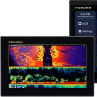
Furuno is expanding its line with the introduction of the TZMAP9 and TZMAP13, two new stand-alone multi-function displays with built-in TruEcho CHIRP™ fish finders.The new models bring the power of Furuno’s TZ MAPS cartography to smaller vessels desiring to operate from a single display. Designed for boaters who want simplified, reliable navigation without network complexity, these models deliver powerful features through a user-friendly multi touch interface for a variety of boat types and sizes.The 9” TZMAP9 and 13” TZMAP13 feature responsive…
Silja Symphony Adopts nauticAi Log Electronic Logbooks

Northern Baltic Sea ferry operator Tallink Grupp, which operates vessels under the Silja Line and Tallink brands, has selected the Finnish-developed nauticAi Log type approved electronic record book for its fleet of ships, with the Swedish-flagged cruise ferry Silja Symphony as the first one to go paperless. “We switched to paperless engine logbooks here on Silja Symphony from 1 June and feel that this is a good step towards even more modern and digitalised operations as well as our overall sustainability goal of going paperless.
NOAA Continues Transition to Electronic Navigational Charts
NOAA is continuing with the sunset plan for paper and raster nautical charts in August and September. A set of 15 charts covering the eastern half of the North Slope of Alaska will be moved into last edition status on August 5, 2021 and will be canceled on February 2, 2022. Another set of 14 charts covering the western half of the North Slope will be moved into last edition status on September 2, 2021 and be cancelled on March 2, 2022.This set of charts has been fully supplanted by new electronic charts as part of NOAA’s Office of Coast Survey Raster Sunset Plan…
SMA Selects Teledyne CARIS

Teledyne CARIS has announced that the Swedish Maritime Administration (SMA) has selected Teledyne CARIS to provide tools for generalization of bathymetric data in nautical charts.Through a competitive tender process, SMA has chosen Teledyne CARIS to provide CARIS BASE Editor as the solution for the generalization of bathymetric data in nautical charts. The software platform will provide the tools needed to generate contours and sounding selections using automated processes as…
SevenCs Updates WMS ChartServer
SevenCs has released WMS ChartServer, version 5, which provides enhanced functionality across several fronts.Greater interoperability is the key to WMS ChartServer’s support of spatial queries; this support takes the depth and relevance of information on offer to a new level, using GeoJSON-formatted coordinates.Interoperability and valuable context were also the benefits fueling the development of bounding boxes that cover more than 360° of latitude. These give customers compatibility…


