Britain Reviewing Risks to its Satellite-Reliant Infrastructure
Britain is reviewing its reliance on satellite-based technology for critical infrastructure including the Global Positioning System (GPS) as the threat of jamming attacks and disruptions grows, a government report said on Tuesday. Emergency services, transport, communications and financial networks are among key sectors which depend on Global Navigation Satellite Systems (GNSS) such as GPS. Such technology needs accurate and reliable position and timing signals. Experts say the problem with GNSS is their weak signals…
Cyber Threats Prompt Return of Radio for Ship Navigation
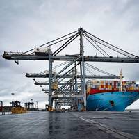
The risk of cyber attacks targeting ships' satellite navigation is pushing nations to delve back through history and develop back-up systems with roots in World War Two radio technology. Ships use GPS (Global Positioning System) and other similar devices that rely on sending and receiving satellite signals, which many experts say are vulnerable to jamming by hackers. About 90 percent of world trade is transported by sea and the stakes are high in increasingly crowded shipping lanes.
Global Shipping Feels Fallout from Maersk Cyber Attack

Global shipping is still feeling the effects of a cyber attack that hit A.P. Moller-Maersk two days ago, showing the scale of the damage a computer virus can unleash on the technology dependent and inter-connected industry. About 90 percent of world trade is transported by sea, with ships and ports acting as the arteries of the global economy. Ports increasingly rely on communications systems to keep operations running smoothly, and any IT glitches can create major disruptions for complex logistic supply chains. The cyber attack was among the biggest-ever disruptions to hit global shipping.
EU Pulls Plug on Back-Up Nav System
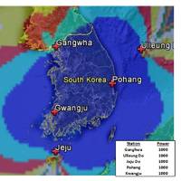
A British-led initiative to create a back-up to satellite navigation systems for ships has been pulled after failing to garner interest from other European countries, despite its proponents pointing to the growing risk of disasters at sea. Vessels increasingly rely on devices that employ satellite signals to find a location or keep exact time, including the Global Positioning System (GPS). Paper charts are used less frequently due to a loss of traditional skills among seafarers. Experts say GPS is vulnerable to signal loss from solar weather effects or radio and satellite interference or deliberate jamming, which South Korea experienced from North Korea in recent years.
Combatting Maritime Cyber Security Threats
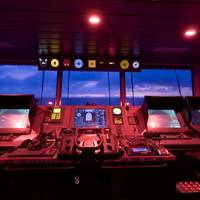
The U.S. Executive Branch has declared that the cyber threat is one of the most serious economic and national security challenges we face as a nation, and that America’s economic prosperity in the 21st century will depend on effective cyber security. Before the maritime industry sounds the danger signal, it needs to monitor other industries and branches of the government and take proactive preventative measures. There is no better place to prepare future and current mariners for these challenges than in maritime simulators.
Threats to Global Navigation Satellite Systems
Originally developed to guide Allied convoys safely across the Atlantic, the use of synchronized low frequency radio signals as a navigational aid revolutionized modern maritime navigation in the 1940s. Faced with operating ships and aircraft over vast areas, researchers pioneered the use of radio signals to aid navigation in regions where poor weather conditions made traditional methods—such as dead reckoning and celestial navigation—exceptionally difficult. This system was eventually named LORAN.
Rising from the Ashes

The federal government is now taking steps to reverse its 2010 decision to terminate the nation’s LORAN program. The LORAN program was initiated during World War II, when US and Allied forces fighting in the Pacific Theater needed a good means of navigation in that vast ocean. The US Coast Guard was charged with establishing and operating chains of Loran-A stations throughout the Pacific. With war’s end, the program was extended to coastal areas of the United States and elsewhere. Over time, Loran-A was replaced by Loran-C, which provided both greater coverage and improved accuracy.
Garamendi Introduces Bipartisan GPS Backup Bill

Congressman John Garamendi (D-Fairfield, CA), the Ranking Member of the House Transportation and Infrastructure Subcommittee on the Coast Guard and Maritime Transportation, introduced the bipartisan National Positioning, Navigation, and Timing (PNT) Resilience and Security Act of 2015, H.R. 1678. H.R. 1678 would require the Secretary of Defense, in coordination with the Commandant of the Coast Guard and the Secretary of Transportation, to establish and sustain a reliable, land…
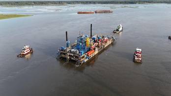
Sanctions Bite Russian Arctic Oil Shippers
Shipping services that support Russia's attempts to extract oil from remote parts of the Arctic will run into difficulties as banks scale back energy financing due to Western sanctions, increasing transport costs for the frontier sector. Sanctions imposed on Russia by the United States and European Union over Ukraine have targeted the delivery of oil technology, goods and services, aiming to make it impossible for Moscow to access new oil sources. The world's largest energy exporter, Russia relies on oil and gas exports for about half its federal budget.
Europe Grapples with Threat of Ships Sailing Blind
Europe has yet to fully wake up to the danger of maritime disasters caused by signal jamming and blackouts of satellite navigation devices, say the proponents of a back up system on trial in British and Dutch ports. Ships increasingly rely on systems that employ satellite signals to find a location or keep exact time including the Global Positioning System (GPS) and GLONASS. But experts say such systems are vulnerable to signal loss from solar weather effects or radio and satellite interference and can also be affected by intentional jamming by criminal gangs, nation states or potentially from militant groups. The General Lighthouse Authorities of the UK and Ireland (GLA) is pioneering a radio-based back-up prototype called eLoran.
U.K., Russia Enter Navigational Technology Collaboration

The General Lighthouse Authorities of the U.K. and Ireland (GLAs) are cooperating with The Internavigation Research and Technical Center in the Russian Federation to achieve compatibility in advanced navigation technologies. The common goal is to improve shipping safety across hazardous new high Arctic routes, which are playing an increasingly important role in international trade. The U.K./Russia cooperation refers specifically to the development of interoperable resilient position…
GPS Spoofing and the Potential Perils to Ships at Sea

Simple annoyance or potential security threat? Spoof is defined as “a hoax or swindle.” In the world of electronic networks, a spoofing attack is a situation in which one program successfully masquerades as another by falsifying data and thereby gaining an improper advantage. We have all heard of, and possibly fallen victim to, fraudulent card readers (often inserted on self-service fuel pumps). The fraudulent card readers copy security information from the credit card, which is then used to clone an illegitimate credit card and incur improper charges on the victim’s credit card account.
New Ship-based System Takes Out GPS Jamming Threat
With GPS jamming a growing worry for UK shipping, a new device seamlessly switches systems to counter the navigational menace. In development since 2005, the ACCSEAS project used a system on the vessel THV Galatea in the seas off Harwich to show that the PNT (Positioning, Navigation and Timing) technology was resilient enough to withstand the worst case scenario of a ship suddenly losing all GPS signals, reports PC Advisor. In theory it would be possible to simply turn off a GPS system and switch on the powerful, longwave eLoran (eLOng RAnge Navigation), but in the middle of a busy shipping lane sea captains don't necessarily realise what is happening to them quickly enough.
Safer Navigation with International Standards for Electronic Systems

Carrying an estimated 90% of world trade and billions of passengers every year, international shipping represents the life blood of the global economy. Safety, always a major concern for seafarers, has made huge advances in the last century. However, the massive increase in traffic in recent decades requires, among other things, new or better global communication and navigation solutions resting on internationally-agreed standards to maintain and improve safety levels. Shipping was among the very first industries to adopt widely implemented international safety standards.
Coast Guard Authorization Act of 2010
On Friday, October 15, President Obama signed into law the Coast Guard Authorization Act of 2010 (H.R. 3619). This is the first such authorization act for the Coast Guard since 2006. The statute is lengthy (128 pages) and addresses a wide variety of maritime issues. This article will attempt to identify those provisions expected to have the most impact or of the most interest. I have grouped these provisions into broad categories, although there is some natural overlap. The Coast Guard is provided specific authority to enforce the U.S. coastwise trade laws and its personnel are to be trained with regard to these laws. This provision is somewhat redundant, in that the agency, since its founding as the Revenue Cutter Service in 1790, has had this authority.
VTC Gets $6.4m Contract
The upgrade of DGPS stations includes adding capability to use Modernized GPS signals and the additional functionality required for tracking the future Galileo and GLONASS signals without further complex upgrade. The upgrade program will also ensure that the GLA service is compliant with the latest International Maritime Organization (IMO) Resolutions and recommendations from the International Association of Lighthouse Authorities (IALA). VTC will also provide ongoing support of DGPS for a further 10 years. The award of this contract builds on VTC’s expertise in the field of electronic navigation and its relationship with the GLAs, where it is delivering a state-of-the-art eLoran navigation service from its radio communications facility in , as part of a 15 year contract signed in 2007.
FY '09 Budget includes eLORAN
President Bush forwarded to Congress the Budget of the United States Government for Fiscal Year 2009 and related documents. Among other things, the Budget documents note enhanced LORAN (eLORAN) has been identified as the primary candidate as the national backup system for position, navigation, and timing. This budget includes funding for modernization of LORAN-C as the first step to implementation of eLORAN. Through a contracting-out arrangement, the Coast Guard will operate the LORAN-C/eLORAN system on behalf of the DHS National Protection and Programs Directorate. In addition, the budget provides $20 million in new funding for more USCG marine inspectors. (HK Law)
DHS Adopts National Backup System to GPS
The U.S. Global Positioning System (GPS) in the event of an outage or disruption in service. The enhanced Loran, or eLoran, system will be a land-based, independent system and will mitigate any safety, security, or economic effects of a GPS outage or disruption. The eLoran system will be an enhanced and modernized version of Loran-C, long used by mariners and aviators and originally developed for civil marine use in coastal areas. that GPS cannot support, such as under heavy foliage, in some underground areas, and in dense high-rise structures. upgraded network.
Coast Guard Auxiliary Seeks Input on Long Range Navigation System
The Coast Guard Auxiliary wants to inform all mariners that the U.S. Department of Transportation, in coordination with the Department of Homeland Security, is seeking public input on the fate of the Long Range Navigation System, otherwise known as LORAN-C. The land-based navigation system, operated by the U.S. Coast Guard, may be scheduled for decommissioninglater this year. At question, is whether the system should be decommissioned, maintained "as is" or up-graded to an enhanced Loran system, eLoran, which could be used either as a back-up to the Global Position Satellite System, or a complimentary system to GPS. The public is invited to submit their thoughts and comments, which must be received on or by Feb.