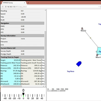
Unmanned Vessel Launched to Survey Western Galveston Bay
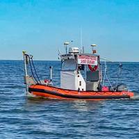
An unmanned vessel is now surveying more than 3,500 nautical miles of the Western Galveston Bay, near the Houston Ship Channel.DEA Marine Services, a division of David Evans and Associates, Inc. (DEA), in Vancouver, Wash., equipped its survey boat Sigsbee with a Sea Machines Robotics SM300 autonomous-command and remote-helm control system to fulfill a National Oceanic and Atmospheric Administration (NOAA) contract.Sigsbee, which is serving as an autonomous daughter craft for the project…
Marine News' Top Boats of 2020
This year, despite innumerable challenges and setbacks, a great number of new U.S.-flagged vessels made their way into service. In addition to Maid of the Mist's new electric tour boats James V. Glynn and Nikola Tesla featured Wednesday, the newbuilds highlighted below are some of the most noteworthy to come out of U.S. shipyards in 2020.DredgerU.S. dredging contractors have been adding tonnage in a big way. This Spring, Callan Marine added a significant piece to the U.S. fleet with its new Jones Act cutterhead suction dredge (CSD) General MacArthur.
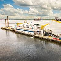
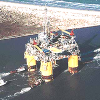
Callan Marine’s New Dredge General MacArthur Enters Service
Callan Marine's new Jones Act cutterhead suction dredge (CSD) General MacArthur and its accompanying idler barge have entered service in Texas, heading to work on several projects before transiting to Corpus Christi for the second phase of the deepening and widening project.The newest and largest dredger in Callen Marine's fleet, the General MacArthur represents the next generation of dredging technology and crew comfort, said Maxie McGuire, President of Callan Marine.“The General MacArthur is a complete game-changer for the dredging industry,” McGuire said.
Remains of Lost 1800s Whaling Fleet Found
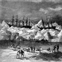
NOAA archaeologists have discovered the battered hulls of two 1800s whaling ships nearly 144 years after they and 31 others sank off the Arctic coast of Alaska in one of the planet's most unexplored ocean regions. The shipwrecks, and parts of other ships, that were found are most likely the remains of 33 ships trapped by pack ice close to the Alaskan Arctic shore in September 1871. The whaling captains had counted on a wind shift from the east to drive the ice out to sea as it had always done in years past.
HYPACK Barge Management System

HYPACK offers a solution to track multiple vessels and share the information across vessels. It also allows any remote viewer with a web browser to observe the survey or construction operations on their PC, tablet or cell phone. Secondary vessels (tugs) are equipped with a Wi-Fi broadcaster which takes their network GPS feed and sends the messages to the Primary vessel (barge). Optional antennas can increase the range from 2km to over 10km. Tugs can then receive their own Area Map showing all vessels using a Web Browser…
HYPACK Offers Barge Management System
HYPACK now offers a solution to track multiple vessels and share the information across vessels. It also allows any remote viewer with a web browser to observe the survey or construction operations on their PC, tablet or cell phone. Secondary vessels (tugs) are equipped with a Wi-Fi broadcaster which takes their network GPS feed and sends the messages to the Primary vessel (barge). Optional antennas can increase the range from 2km to over 10km. Tugs can then receive their own Area Map showing all vessels using a Web Browser…
Unique System & HYPACK's Hydrographic Course in UAE
A division of the Unique Maritime Group (UMG) which is one of the world’s leading integrated turnkey subsea and offshore solution providers, Unique System FZE in conjunction with HYPACK Inc. has successfully conducted HYPACK’s hydrographic & offshore survey training course at its training centre in Hamriyah Free Zone, Sharjah, UAE. As a precursor to this hugely popular course, a string of training topics, both technical and operational remarkably influencing the current market trends in the survey industry were also discussed as a part of the training schedule. The training courses were held from the 16th to the 27th of November 2014. HYPACK is one of the most widely used hydrographic surveying packages in the world, with more than 4,000 users.
New Anchor Handling Routine in HYPACK
HYPACK Inc. announced the release of a new Anchor Handling Routine for the offshore construction market. Hydrographic and survey software company HYPACK, Inc said it has used its in-house expertise and input from a world leading Survey Company to design and develop the new Anchor Handling Routine. that allows both rig and anchor handling vessels (tugs) operators to graphically display the status and location of anchors and their cables, track their movement and deployment, and send the anchor locations to the anchor handling vessel operators.
HYPACK Automatic Download of ENC Charts
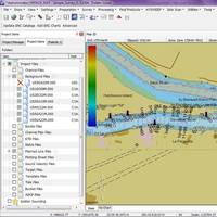
The new HYPACK feature allows U.S.-based users to quickly obtain the most recent charts provided by NOAA and the USACE at no additional charge. U.S.-based users who have an Internet connection will be able to download the charts from the USACE and NOAA web-map servers with the click of a button. Both agencies have made their charts available for download, and HYPACK has made it easy to ensure users have the latest chart data. Step One: Update ENC Catalog: HYPACK downloads the latest chart catalogs over the Internet from the NOAA and USACE map servers.
Expanding Underwater Search Capabilities
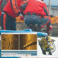
Over the past year a number of Asian companies and government agencies have acquired underwater search equipment to aid in the location of lost objects and assist in performing survey operations. In China, Guangzhou Advanced Maritime Academy has added a remote operated underwater vehicle (ROV) to their program. Reforms and opening to the outside world have paved the way for development of the country’s shipping industry. The throughput of cargo and containers at China’s ports has been the largest in the world for the past five years with an annual growth rate of 35%.
Vessels: Kvichak Delivers for NY 58-ft. Survey Vessel Joins NY Fleet
New York Corp's newest survey vessel - Moritz - has already joined the fleet. The 58-ft. catamaran was built in Seattle by Kvichak Marine Industries, Inc. and was outfitted with an extensive array of survey equipment, including a "Ross Dolphin Mini-Sweep System". The vessel was shipped via the Panama Canal in early August to join the New York District fleet. At 58 ft. long, with a beam of 18.5 ft., the vessel displaces 30 tons and can sustain speeds up to 30 knots. The Ross Mini-Sweep is a nine (9) channel system with individual transducers mounted on two 17 foot hydraulic booms and in the hull to provide a sweep wide of approximately 55 ft. The booms are stored in recessed areas in the hull, leaving the deck clear at all times.
Ross Labs Delivers a 35-ft. Survey Boat
the U.S. Army Corps of Engineers - Rock Island District. multi-channel survey system, designed for inland rivers and shallow water surveying. The "Mini-Sweep" is ideally suited for installation on small trailerable vessels. for Rock Island District included a custom designed 35 ft. Marine, Inc. of Monticello, Arkansas. Two 20-ft. booms mounted on either side of the vessel provide a 50-ft. overall sweep width. The booms are stored in recessed areas in the hull, leaving the deck clear at all times. are deployed by a hydraulic system using controls at the helm station. computer, and DGPS sub-meter system. used for data processing. The second boat, currently under construction at SeaArk Marine, is a 34-ft. which will be outfitted with 20 ft. for delivery this fall.
Ross Labs Delivers Survey Boat
In mid-May Ross Laboratories, Inc., Seattle, Wash., delivered the first of two survey boats to the U.S. Army Corps of Engineers - Rock Island District. The Ross "Mini-Sweep" is a small boat multi-channel survey system, designed for inland rivers and shallow water surveying. surveyor who worked for the RI District who recently passed away. The "Mini-Sweep" is ideally suited for installation on small trailerable vessels. The "turn-key" system for Rock Island District included a custom designed 35 ft. twin-hull workboat from SeaArk Marine, Inc. of Monticello, Ark. Two 20-ft. booms mounted on either side of the vessel provide a 50-ft. overall sweep width. The booms are stored in recessed areas in the hull, leaving the deck clear at all times.
Sea Technology Report
The Woods Hole Oceanographic Institution (WHOI), the largest independent institution of its kind in the world, recently began developing a new piston corer for retrieving sediments from the ocean floor. Once complete in 2006, the deep-water coring system will be the largest in the U.S. and among the biggest in the world. The corer’s enormous weight — 25,000 pounds — coupled with the environmental demands associated with working in water up to 20,000 ft. deep presented major technical challenges to the system required to lower the corer to the sea floor then recover it, along with its ancient sediment samples. Located in Cape Cod, Mass.…
Ross Labs Delivers Mini-Sweep System
Ross Laboratories, Inc. delivered the second “Ross Mini-Sweep System” to the U.S. Army Corps of Engineers, Rock Island District. The on-time delivery is the second sweep boat system to the Rock Island District in the past twelve months. The “Mini-Sweep” is ideally suited for installation on small trailerable vessels. The “turn-key” system for Rock Island District is installed on a custom designed 34-ft. cathedral hull work boat from SeaArk Marine, Inc. of Monticello, Arkansas. The “Mini-Sweep” system is specifically designed for inland and shallow water surveying. Two 20-ft. hydraulically operated booms mounted on either side of the vessel will provide a 50-ft. overall sweep width. The booms are stored in recessed areas in the hull, leaving the deck clear at all times.