

Great Ships 2019: T. Elinor
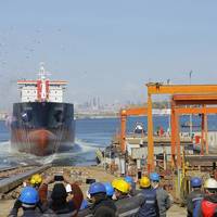
Adnan Nefesoğlu, RMK MARINE’s CEO, thought a short moment and replied by reflecting his self-confidence “Yes, we can do”, when the local client came and asked RMK MARINE in early 2016 that: “We have two main engines, procured eight years ago and standing in a depot since then. They have Tier I feature. Can you convert them first to Tier II compliant engines, to be followed with Tier III compliant features, make them fully operable and then can you build two ships around 15.000-16.000 dwt…
C-MAP Unveils Insight Chart Options
Global cartography leader C-MAP is set to introduce a new series of map products for boaters. The new U.S. mapping products — C-MAP Insight Pro and C-MAP Lake Insight HD — combine the trusted chart detail, unique content and popular graphical presentation of C-MAP cartography with exclusive chart data from GoFree Lake Insight charts. Boaters and anglers using these charts will also benefit from millions of acres of customized data from the Insight Genesis Social Map, providing the most up-to-date views of underwater contours and lake bed features gathered and shared by actual boaters on the water. C-MAP Insight Pro gives both coastal and freshwater anglers powerful features designed to enhance their time on the water.
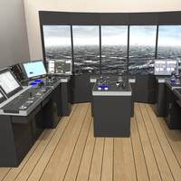
Simulation Complex for Paraguay Waterway Training
The Transas navigational simulator Navi-Trainer Professional 5000 was installed at the Center for Maritime and River Shipowners (CAFyM) in Asuncion for training crews in tugs operations in the Parana-Paraguay Waterway. The project was carried out in conjunction with VTG S.R.L., the Transas' local representative, which is covering commercial and technical needs of the Paraguayan market for all Transas products. The NTPRO version 5.35 installed at the CAFyM center is an excellent training solution due to its new capabilities for operation with different types of boats and barges in river waters.
NavPlay Debuts App for American Boaters
NavPlay, an innovative manufacturer of iPad apps for boaters, announced today its release of a new app designed specifically for American boaters – NavPlay US. Offering downloadable access to detailed NOAA vector maps, NMEA 2000 compatibility and WiFi-integration with onboard navigation and safety technologies, NavPlay US provides the tools needed to manage all aspect of yachting, right from an iPad, anywhere on a vessel. A powerful, robust and easy-to-use navigation app, NavPlay US allows boaters to download, plan routes and navigate using NOAA vector charts from Aqua Map. Delivering crystal clear detail and ultra fast refresh rates…
Fugawi Debuts Quilted Charts
Industry leading online chart service Fugawi X-Traverse, announced today that in coordination with GPSNavXTM and its app, iNavX, the availability of quilted raster charts for the navigation app’s most recent version. One of the most established marine navigation apps on the Apple iOS platform, iNavX brings the latest marine navigation features to iPhone and iPad users. In an exciting revision of the top-selling app, iNavX adds greater functionality to its already robust feature set. Offering users the ability to plot position in real-time on multi-touch marine charts with scroll, zoom and rotate, the app can also act as a repeater for popular marine navigation software that supports NMEA data over TCP/IP. They weather forecasts; and even an anchor alarm.
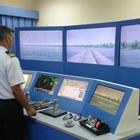
Aalesund University College Upgrades Navigation Simulator
Aalesund University College has become one of the first Kongsberg Maritime simulator users to migrate to the new simulator technology platform, K-Sim Navigation. In a contract signed on January 6, 2015 following an open tender by the college, Kongsberg Maritime will deliver a new K-Sim Navigation aft and forward bridge configuration, which is DNV Class B compliant with an integrated DP2 simulator. Installation is scheduled for May 2015. The University College has also signed a…
Kongsberg Maritime Launches K-Sim Navigation
Kongsberg Maritime has unveiled its latest generation ship’s bridge simulator, K-Sim Navigation, which meets the requirements of the most demanding navigation training for merchant, offshore and naval vessels. Designed for the future of advanced and integrated simulation training, K-Sim Navigation is based on a new cutting-edge technology platform enabling more realistic training scenarios and enhanced user benefits for both instructors and students. K-Sim Navigation features an advanced physical engine and state-of-the-art hydrodynamic modelling…
Navplay's Debuts Experience Maker
NavPlay, an innovative manufacturer of iPad apps for boaters, announced today its revolutionary story telling functionality, Experience Maker. A unique and innovative feature that is exclusive to the NavPlay app, this new feature gives boaters the ability to share moments of and during their journeys using their iPads. Leveraging the power of the LogBook and Alarm Manager environments, Experience Maker provides an easy-to-use interface for boaters to capture the truly personal details of their adventures, relive each moment and share their journeys with shipmates, family and friends. A complete, easy-to-use navigation app for iPads, NavPlay allows boaters to plan routes and navigate on C-Map by Jeppesen charts and satellite imagery.
USCG Testing eATON in San Francisco Bay
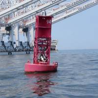
The U.S. Coast Guard (USCG) said it is now testing 25 electronic aids to navigation (eATON) to augment existing physical aids and mark unique and potentially hazardous navigation features in the San Francisco Bay Area. Commonly referred to as “virtual” buoys, the eATON are being transmitted through the Coast Guard’s Nationwide Automatic Identification System (NAIS) for display on ships’ electronic charting systems and radars. As part of ongoing efforts to increase the safety of navigation on the Bay the Coast Guard…
America's First 'Virtual' Aids to Navigation on Test
The Coast Guard informs it is now testing 25 electronic aids to navigation (eATON) to augment existing physical aids and mark unique and potentially hazardous navigation features in the San Francisco Bay Area. Commonly referred to as “virtual” buoys, the eATON are being transmitted through the Coast Guard’s Nationwide Automatic Identification System (NAIS) for display on ships’ electronic charting systems and radars. It is explained that as part of ongoing efforts to increase the safety of navigation on the Bay the Coast Guard, in close consultation with waterway users, identified multiple offshore and inshore locations to deploy the eATON.
Nobeltec App Wins 2013 NMEA Award
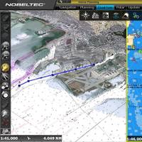
National Marine Electronics Association (NMEA) annually recognizes companies that have demonstrated innovation and excellence by selecting products that have stood out from competitors in terms of functionality, usability and quality. Nobeltec was represented at the NMEA conference in San Diego last week by its Chief Technical Officer Iker Pryszo, as well as our Sales Manager Rodell Razor. Iker accepted the NMEA award for Computer Based Software on behalf of Nobeltec, which honored its product TimeZero App for iPad, based on TimeZero technology.
New Jeppesen Cartography Available
Jeppesen’s new C-MAP MAX-N Wide cartography, designed for popular navigation systems from global marine electronics leader Navico, is now available to boaters worldwide through the Navico Insight Store and Jeppesen authorized dealers. MAX-N Wide is compatible with Lowrance Elite 7 and HDS Gen1, Gen2 and Gen2Touch; Simrad NSS, NSE and NSO and B&G Zeus Touch Multifunction Navigators. These navigation systems have are used across a spectrum of boaters, including fishermen, cruisers and sailors…
Boatracs Presents ChartView At Workboat
Boatracs, a business unit of Advanced Remote Communication Solutions (ARCOMS) has formed a strategic alliance with Nobeltec Corp., a developer of charting and navigation software. Together, they will spotlight ChartView Celestial Mariner, Boatracs' and Nobletec's nautical charting navigation and communications software, which was presented at the 1999 Fish Expo in Seattle during November. The product was shown again at the International Workboat Show in New Orleans in December. ChartView is a complete electronic charting and navigation solution for the marine navigator. It includes all the renowned planning and navigation features that mariners need, while offering auto-pilot controls, an integrated captain's log and the GPS Data Manager.


